Boundary and Annexation Survey
Boundary and Annexation Survey (BAS)
BAS Technical Guide
Boundary and Annexation Survey
OMB: 0607-0151
BAS
Technical Guide Supplemental
Technical and Background Information for the Boundary and Annexation
Survey
Supplemental
Technical and Background Information for the Boundary and Annexation
Survey

Last Updated January 2026
Table of Contents
Chapter 1 Census Bureau Systems and Data Integrity 1
1.1 Topological Relationships in the MAF/TIGER System 1
1.2 GIS and Spatial Accuracy 2
1.3.2 Address Range Geocoding 4
1.3.3 Geocoding, Boundaries, and BAS Submissions 5
Chapter 2 BAS Submission Information 6
2.1 Government IDs and Geographic Codes 6
2.2 Submission File Naming Convention 6
2.2.1 Change Polygon Shapefile 6
2.2.2 Whole Entity Polygon Shapefile 7
2.2.3 Street Feature Change Shapefile 7
Chapter 3 Submission Types 8
3.1 Legal Boundary Submissions 8
3.1.1 Legal Boundary Changes 8
3.3 Street Feature Submissions 11
Chapter 4 BAS Partnership Shapefiles 13
4.1 Accessing the BAS Partnership Shapefiles 13
List of tables
Table 1: Change Polygon Shapefile Naming Conventions 6
Table 2: Whole Entity Polygon Shapefile Naming Conventions 7
Table 3: Linear Feature Change Shapefile Naming Convention 7
Table 4: State Shapefile Names 13
Table 5: County Shapefile Names 14
Table 6: Relationship Table Names 16
Table 7: All Lines Shapefile (PVS_25_v2_edges) 16
Table 8: Census Block Shapefile (PVS_25_v2_tabblock2020) 18
Table 9: Census Tract Shapefile (PVS_25_v2_curtracts) 18
Table 10: American Indian Areas Shapefile (PVS_25_v2_aial) 19
Table 11: County and Equivalent Areas Shapefile (PVS_25_v2_county) 20
Table 12: County Subdivisions Shapefile (PVS_25_v2_mcd) 21
Table 13: Incorporated Place Shapefile (PVS_25_v2_place) 22
Table 14: Census Designated Places Shapefile (PVS_25_v2_cdp) 23
Table 15: Consolidated Cities Shapefile (PVS_25_v2_concity) 24
List of Figures
Figure 1: Topological Integration of Four Feature Classes 1
Figure 2: Overlay of Four Feature Classes 2
Figure 3: Snapping Boundaries to the Centerline 3
Figure 4: GPS Method of Geocoding 4
Figure 5: Address Range Geocoding 5
This How-to Guide is a supplemental resource that contains background information and technical details about U.S. Census Bureau geography, Boundary and Annexation Survey (BAS) submission information, change types, and shapefiles.
This information is applicable for all three BAS submission
methods–the BAS Partnership Toolbox (ArcGIS Pro), the
Geographic Update Partnership Software (GUPS) Web, and paper. For
detailed instructions on creating a BAS submission using one of these
three submission methods, refer to the corresponding How-to Guide
located on the BAS website at
<www.census.gov/programs-surveys/bas/information/respondent-guides.html>.
The Census Bureau’s Geography Division develops geographic applications and executes related activities in support of data collection and dissemination. For more than twenty years, the Census Bureau’s Master Address File and Topologically Integrated Geographic Encoding and Referencing (MAF/TIGER) System has been a critical resource for supporting the various geographic partnership programs conducted by the Census Bureau.
The following section describes how the Census Bureau uses a topologically integrated system and how this differs from traditional geographic information system (GIS), which use separate layers of data.
At the Census Bureau, topology is described as the spatial relationship between different levels of geography. The MAF/TIGER System is a geographic database in which the topological structures define the location, connection, and relationships of streets, rivers, railroads, and other features. These topological structures help define geographic areas for data tabulation.
Instead of having a separate layer for each feature class (roads, boundaries, etc.), all information in the MAF/TIGER System is stored in one layer or file. See Figure 1 for a sample of topologically integrated data in the MAF/TIGER System.
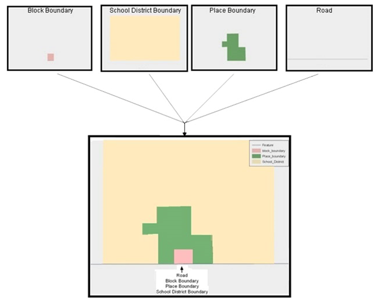
Figure 1: Topological Integration of Four Feature Classes
This example shows the topological integration of four different feature classes into one layer. One road feature represents not only a road, but also a block boundary, place boundary, and a school district boundary.
In a GIS, feature classes are often not topologically integrated; instead, they are separated into individual datasets. When these datasets are overlaid in a GIS, there may be boundary misalignments. These non-topologically integrated datasets could cause issues in the MAF/TIGER System. Figure 2 shows how files that are not topologically integrated might appear in a GIS when overlaid.
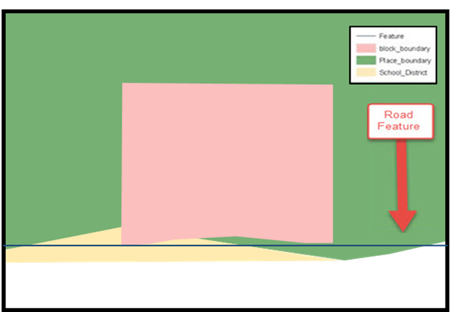
Figure 2: Overlay of Four Feature Classes
This example shows an overlay of four separate feature classes. Notice how the topological relationship is compromised. The block, place, and school district boundaries, which are supposed to follow the road feature, are no longer aligned with the road in several locations.
The spatial differences between local GIS data and the Census Bureau’s topologically integrated file are often very small (less than ten feet) and can create boundary-to-feature relationship issues for the Census Bureau. To avoid such issues, the Census Bureau will snap boundary changes to a MAF/TIGER System feature when it exists within 30 feet of that feature as shown in Figure 3. This ensures that housing and population are correctly tabulated to all geographies.
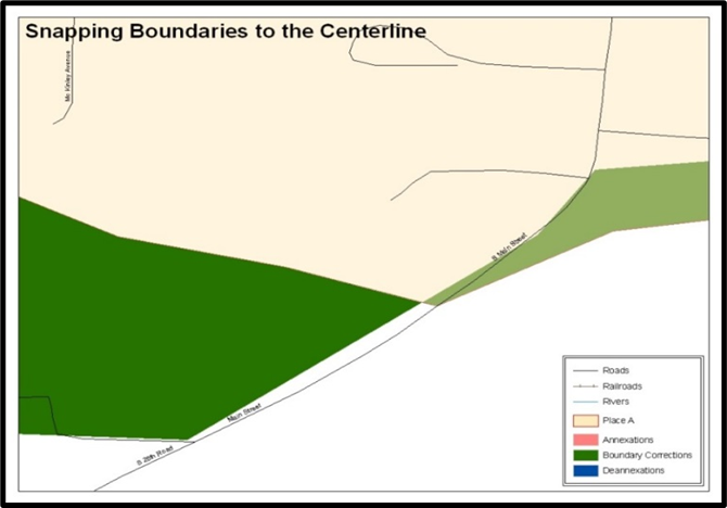
Figure 3: Snapping Boundaries to the Centerline
These boundary corrections are not snapped to existing linear features in the MAF/TIGER System. The Census Bureau will snap both boundary corrections to the centerlines to avoid population being assigned to incorrect governments.
Geocoding is how the Census Bureau codes the location of the housing and population within the boundaries of a geographic area. There are two primary methods of geocoding used by the Census Bureau, and both involved coding an address to a spatial polygon. One uses Global Positioning System (GPS) technology to create a MAF structure point (MSP), and the other uses address ranges for geocoding.
To collect an MSP, a field worker stands in front of a house or living quarters and records the physical location with a GPS device (Figure 4). Usually, the GPS point falls very close to the front door of the house. However, since GPS points are collected in the field, real-world obstacles like locked fences, poor satellite reception, or even aggressive dogs might prevent the field worker from gaining access to the front door. In these circumstances, the field worker may have to take the GPS coordinate from the sidewalk or side of the road.
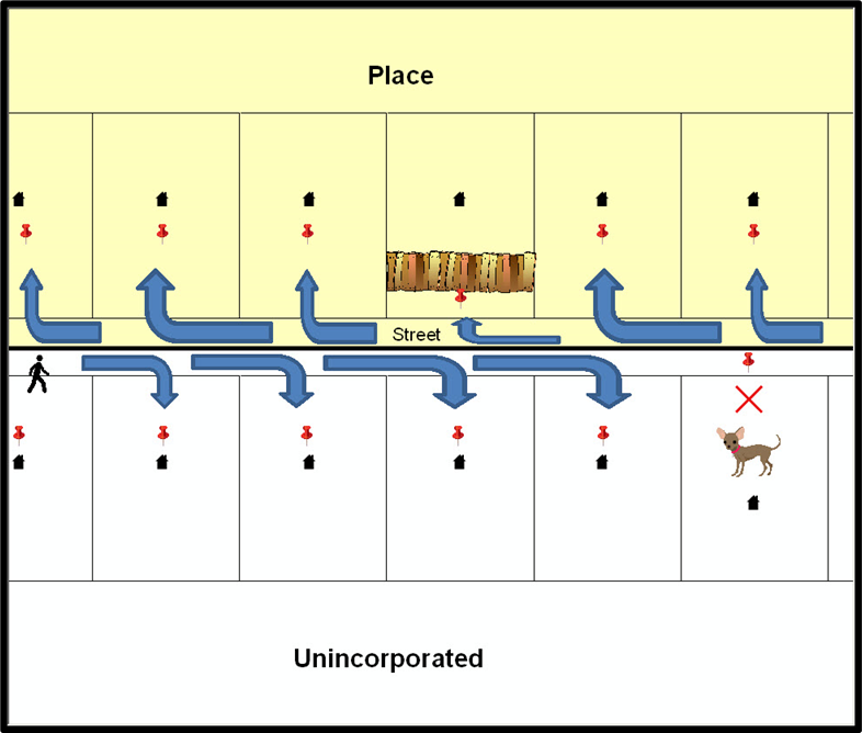
Figure 4: GPS Method of Geocoding
Notice that it is occasionally not possible for the field worker to go all the way to the front door due to unforeseen circumstances, like the fence or the dog shown above. Thus, the MSP (represented here by the red pins) can sometimes fall within the road or the road right-of-way.
When it is not possible to collect an MSP, the Census Bureau codes houses and living quarters according to the address range associated with the adjacent stretch of road (Figure 5). Address ranges describe a label given to a unique collection of addresses that fall along a road or path. Address ranges provide a way of locating homes and business based on their street address when no other location information is available. The Census Bureau conducts numerous operations and processes to build and maintain high quality address ranges.
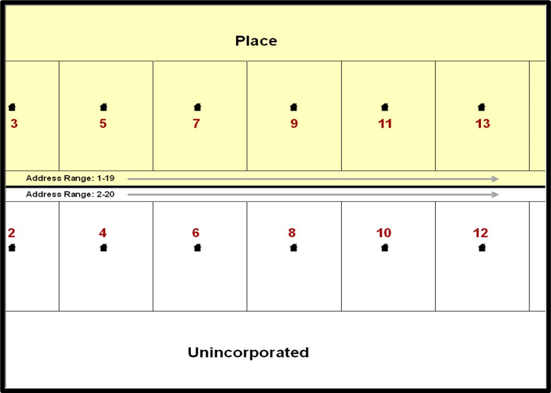
Figure 5: Address Range Geocoding
When it is not possible to collect an MSP, houses are geocoded according to their placement along a range of potential addresses along that road. Since the address has a relationship with the road, boundaries placed on front-lot-lines will lead to mis-geocoding unless an offset flag is used.
While the two methods of geocoding differ greatly, both rely heavily on the integrated nature of the MAF/TIGER System. These geocoding methods are affected by the way streets and boundaries are represented in relation to one another. This interdependence between streets, boundaries, and geocoding means that Census Bureau representation of legal boundaries sometimes differs from other representations (e.g., in local or state GIS). This is important when adding geographic corridors and offsets that follow road right of ways (or the front-lot-lines of parcels). In both figures 4 and 5 above, delineating a boundary along the front-lot-line will increase the risk of incorrect geocoding. Using the road centerline as a boundary is the safer method.
If a road or road right-of-way is owned or maintained by a place but the adjacent housing is not, the centerline of the road should be used as the boundary. If local or state law requires the use of the front-lot-line boundary, the area between the road centerline and the front-lot-boundary should be designated as a corridor or an offset.
The GOVID, previously called the BAS ID, is the code the Census Bureau uses to identify each government. All federally recognized American Indian areas (AIA), counties (and equivalent areas), incorporated places, consolidated cities, and minor civil divisions (MCDs) are assigned and identified by unique GOVIDs. Each GOVID can be found on the BAS Annual Response email sent at the start of each BAS year. A list of GOVIDs and other geographic codes can be found online at <www.census.gov/programs-surveys/bas/technical-documentation/code-lists.html>.
The following tables provide the naming conventions for the various submission shapefiles. For all tables in this section, <GOVID> represents the participant’s GOVID and <yy> represents the current year.
The following table provides change polygon shapefile naming conventions. The GOVID for the participant should be used when naming the shapefiles even if they are submitting changes for another level of geography.
Table 1: Change Polygon Shapefile Naming Conventions
-
Participant
Submitting Changes For
Shapefile Naming Convention
County
County
bas<yy>_<GOVID>_changes_county.shp
County
MCD
bas<yy>_<GOVID>_changes_cousub.shp
County
Incorporated Place
bas<yy>_<GOVID>_changes_incplace.shp
MCD
MCD
bas<yy>_<GOVID>_changes_cousub.shp
Incorporated Place
Incorporated Place
bas<yy>_<GOVID>_changes_incplace.shp
Consolidated City
Consolidated City
bas<yy>_<GOVID>_changes_concity.shp
County
Census Designated Places
bas<yy>_<GOVID>_changes_cdp.shp
AIA
AIA
bas<yy>_<GOVID>_changes_aiannh.shp
AIA
Tribal Subdivision
bas<yy>_<GOVID>_changes_tribalsub.shp
Hawaiian Home Lands
Hawaiian Home Lands
bas<yy>_<GOVID>_changes_hhl.shp
The following table provides the whole entity polygon shapefile naming conventions. The BAS ID for the participant should be used when naming the shapefiles even if they are submitting changes for another level of geography.
Table 2: Whole Entity Polygon Shapefile Naming Conventions
Participant |
Submitting Changes For |
Shapefile Naming Convention |
County |
County |
bas<yy>_ <GOVID>_WholeEntity_county.shp |
County |
MCD |
bas<yy>_<GOVID>_WholeEntity_cousub.shp |
County |
Incorporated Place |
bas<yy>_<GOVID>_WholeEntity_incplace.shp |
MCD |
MCD |
bas<yy>_<GOVID>_WholeEntity_cousub.shp |
Incorporated Place |
Incorporated Place |
bas<yy>_<GOVID>_WholeEntity_incplace.shp |
Consolidated City |
Consolidated City |
bas<yy>_<GOVID>_WholeEntity_concity.shp |
AIA |
AIA |
bas<yy>_<GOVID>_WholeEntity_aiannh.shp |
AIA |
Tribal Subdivision |
bas<yy>_<GOVID>_WholeEntity_tribalsub.shp |
Hawaiian Home Lands |
Hawaiian Home Lands |
bas<yy>_<GOVID>_WholeEntity_hhl.shp |
The following table provides the naming convention for the street feature change shapefile.
Table 3: Linear Feature Change Shapefile Naming Convention
Participant |
Submitting Changes For |
Shapefile Naming Convention |
All Participants |
Streets |
bas<yy>_<GOVID>_changes_ln.shp |
The Census Bureau accepts submissions for changes to legal boundaries, census designated places (CDPs), and streets through BAS.
To update the MAF/TIGER System, participants must create a separate change polygon layer for each updated government type (county, MCD, place, CDP). Change polygons should be created in relation to the current MAF/TIGER System boundary.
The Census Bureau will snap any legal change or boundary correction to a MAF/TIGER System feature when it exists within 30 feet of that feature.
Legal boundary submissions include any updates to legal boundaries, including incorporated places, MCDs, counties, and tribal governments. Change types available for legal boundary submissions are legal boundary changes, boundary corrections, geographic corridors and offsets, and tribal subdivisions.
Legal boundary changes are the result of legal actions. These include:
Annexations or additions.
Deannexations or deletions.
New Incorporations.
Disincorporations (and Inactive Entities).
Name and/or Legal Description Changes.
Legal boundary change submissions from incorporated places, MCDs, and counties must provide the legal documentation number (e.g., law or ordinance number), effective date, and authorization type in the appropriate fields of the changes shapefile. For annexations and deannexations, the Census Bureau does not need the document itself to accept the changes if the required information is provided. AIA legal documentation (e.g., statute, federal court decision, trust deed) must accompany all AIA legal boundary changes.
New incorporation or disincorporation paperwork must be provided with those changes, and new incorporations must also include contact information for the Highest Elected Official (HEO) and BAS contact of the newly incorporated government. Similarly, changes to the name or legal description (e.g., town to city, etc.) must include the paperwork that enacted those changes. Inactive governments, or those without a functioning government that are still incorporated, only need confirmation that they hold that status.
A boundary correction is the spatial adjustment of a boundary to correct an error in how the Census Bureau depicts an existing boundary. Boundary corrections should follow the general shape of the existing boundary. Legal documentation is not required when submitting a boundary correction to the Census Bureau.
The Census Bureau will accept and process boundary corrections:
Where the existing boundary has been digitized incorrectly or appears in the incorrect location due to Census Bureau activities.
Where the overall shape of the geographic area is maintained, and no boundary-to-feature relationships are dissolved.
The Census Bureau will not accept boundary corrections:
Along county boundaries if the affected counties do not agree on the location of the boundary.
Between adjacent incorporated places or adjacent MCDs if the affected places or MCDs do not agree on the location of the boundary, unless the changes are submitted by a county that is part of a Consolidated BAS (CBAS) agreement.
That dissolve boundary-to-feature relationships (roads, rivers, railroads, etc.) if the difference is less than 30 feet.
Greater than one square mile or not contiguous with the rest of the government boundary. These boundary corrections may be part of annexations that were never reported to the Census Bureau. If they are previously unreported legal changes, legal documentation is required.
With a width of less than 30 feet at the widest point unless the change affects a housing unit.
The Census Bureau geocodes addresses based on the street centerline. If the geocoding of these addresses would result in the assignment of population to the incorrect government, a geographic corridor should be created. A geographic corridor is an area that includes only the road (or other feature’s) right-of-way and does not contain any structures addressed to either side of the street.
The left side of Figure 6 shows a corridor (shown in color) created where the incorporated place annexed the right-of-way, but the housing units are not included in the incorporated place. Corridors are often used to connect two disconnected parts of a government when local law does not permit for discontinuous annexations. This type of corridor can be included in a BAS submission.
The right side of Figure 6 shows that the right-of-way belongs in the unincorporated area, while the housing units are included in the incorporated place (shown in color). This is important for some cities because they are portraying that the city is not responsible for road maintenance. This is not relevant for Census Bureau tabulations and is not easy to depict in the MAF/TIGER System. This type of corridor should not be included in a BAS submission.
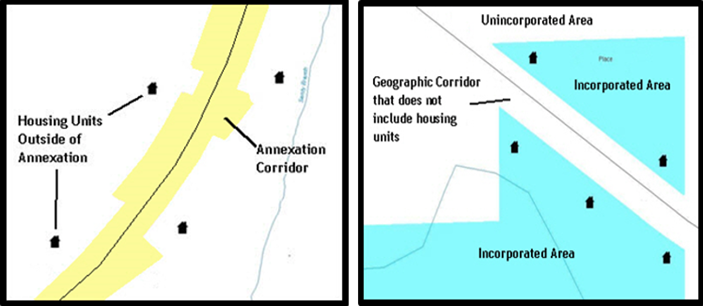
Figure 6: Geographic Corridor Creation
The left side of the image shows a corridor that has been created where an incorporated place annexed the road right-of-way, but not the housing units assigned to either side of the road. The right side of the image shows that the geographic corridor should not be created and features should be snapped to the street centerline.
A geographic offset is an area claimed by a government that is only on one side of a road and does not include structures addressed to that side of the road.
The Census Bureau is aware that many governments base their legal boundaries on cadastral (parcel-based) right-of-way mapping. The Census Bureau bases its maps on spatial data that is topologically integrated, which makes the maintenance of geographic offsets inefficient. Delineating a government boundary on the road centerline helps establish more accurate population counts. If a boundary is on the front-lot-line adjacent to a road on the map, the Census Bureau prefers that the boundary be delineated on the road centerline already shown on the map. If a boundary is on the rear or side lot line, then it should be depicted as such. The left side of Figure 7 depicts a cadastral boundary map and the right side shows how the boundary should be reported to the Census Bureau.
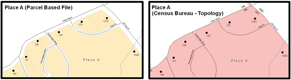
Figure 7: Cadastral Data and Census Bureau Topology
On the left in is an example of cadastral data. On the right is the same area shown edited to conform to Census Bureau requirements.
The Census Bureau considers any type of unit of self-government or administration in tribal areas as a tribal subdivision. A tribe may submit only one type of subdivision, even if it has more than one type of distinct administrative area that could qualify as a tribal subdivision
(e.g., tribal election districts, tribal water districts, or health service areas with different boundaries). Tribal subdivisions can only exist on the reservation and off-reservation trust land, but tribal subdivisions do not have to cover the entire reservation and trust land. The Census Bureau recognizes two types of tribal subdivisions - active (A) or inactive (I):
Active subdivisions are defined as having a functioning government, with elected officials, that provides programs and services.
Inactive subdivisions have no functioning government or elected officials and receive services solely from the tribe.
The name of each tribal subdivision must reflect its name, as cited in recent legal documentation and/or used by the tribal government, for administrative purposes.
CDPs are closely settled, unincorporated communities that are locally recognized and identified by name. They are the statistical equivalents of incorporated places, with the primary differences being the lack of a legally defined boundary and an active, functioning governmental structure, chartered by the state, and administered by elected officials.
Participants have the option to submit new CDPs, make boundary corrections to existing CDPs, and remove CDPs through BAS.
It is important that Census Bureau data reflects the most recent streets to locate housing units and delineate statistical areas. The Census Bureau will not accept files containing a complete street network. Instead, we will accept following street updates:
Adding named streets missing in the Census Bureau BAS Partnership Edges shapefile (PVS_25_v2_edges.shp). The edges shapefile is described in Table 7. The new streets must be named and exist on the ground or be under construction (no paper or planned streets).
Deletions for streets in the Census Bureau BAS Partnership Edges shapefile that does not exist or are in the incorrect location.
Reshapes for spatially inaccurate named streets in the Census Bureau BAS Partnership Edges shapefile.
Renames and MAF/TIGER Feature Class Code (MTFCC) reclassifications for streets with incorrect street names and/or MTFCC values in the Census Bureau BAS Partnership Edges shapefile.
The street name and MTFCC are required for any roads being added to the Census Bureau’s streets network. The Census Bureau does not accept new street adds for driveways, parking lot roads, unnamed alleys and other types of unnamed or non-addressable streets. More information about MTFCCs can be found in section 4.4.
The BAS Partnership Shapefiles reflect the legal boundaries and names for all governments, as reported through the previous year’s BAS.
The Census Bureau’s partnership shapefiles are available for download from the Partnership Shapefiles webpage. These files are in GCS NAD83 format and can be projected into any local coordinate system/project. Most GIS software packages will allow users to transform file coordinate systems and projections.
IMPORTANT: Be certain to select the version used for BAS (v2) and not the other versions that may appear on the page.
State-level Shapefile Names–PVS_25_v2_<layername>_<SS>.shp where <SS> is the two-digit code corresponding to the state, for example, “25” and <layername> is the abbreviation for the geography type represented in the shapefile. No state level shapefiles are described in section 4.3.
Table 4: State Shapefile Names
Shapefile Layer |
<layername> |
Alaska Native Regional Corporation |
anrc |
American Indian / Alaska Native Areas – Statistical |
aias |
American Indian Areas – Legal |
aial |
American Indian Areas 2020 – Legal |
aial2020 |
American Indian Tribal Subdivisions – Legal |
aitsl |
American Indian Tribal Subdivisions – Statistical |
aitss |
Congressional Districts |
cd |
Core Based Statistical Areas |
cbsa |
Hawaiian Home Lands |
hhl |
School Districts (Elementary) |
elsd |
School Districts (Secondary) |
scsd |
School Districts (Unified) |
unsd |
School Districts Administrative Areas |
sdadm |
State Legislative Districts (Upper / Senate) |
sldu |
State Legislative Districts (Lower / House) |
sldl |
Public Use Microdata Areas 2020 |
puma2020 |
2020 Census Tracts |
tracts2020 |
Census Designated Places |
cdp |
Counties and Equivalent Areas |
county |
Counties and Equivalent Areas 2020 |
county2020 |
County Subdivisions – Legal |
mcd |
Incorporated Places |
place |
States and Equivalent Areas |
state |
Tribal Block Groups |
tbg |
Tribal Census Tracts |
tct |
Urban Areas Census 2020 |
uac |
Block Area Grouping |
County-level Shapefile Names–PVS_25_v2_<layername>_<SSCCC>.shp, where <SSCCC> is the five-digit code corresponding to the state and county, for example, “24001” and <layername> is the abbreviation for the geography type represented in the shapefile.
Table 5: County Shapefile Names
Shapefile Layer |
<layername> |
Alaska Native Regional Corporation |
anrc |
American Indian / Alaska Native Areas – Statistical |
aias |
American Indian Areas – Legal |
aial |
American Indian Tribal Subdivisions – Legal |
aitsl |
American Indian Tribal Subdivisions – Statistical |
aitss |
Congressional Districts |
cd |
Core Based Statistical Areas |
cbsa |
Hawaiian Home Lands |
hhl |
School Districts (Elementary) |
elsd |
School Districts (Secondary) |
scsd |
School Districts (Unified) |
unsd |
School Districts Administrative Areas |
sdadm |
State Legislative Districts (Upper / Senate) |
sldu |
State Legislative Districts (Lower / House) |
sldl |
Public Use Microdata Areas 2020 |
puma2020 |
Urban Growth Areas |
uga |
Census Block Groups |
bg |
Census Blocks – Current |
tabblock |
Census Blocks – 2020 Census |
tabblock2020 |
Census Tracts – Current |
curtracts |
2020 Census Tracts |
tracts2020 |
Census Designated Places |
cdp |
Consolidated Cities |
concity |
Counties and Equivalent Areas |
county |
County Subdivisions for counties with Legal Subdivisions |
mcd |
County Subdivisions for counties with Legal Subdivisions |
ccd |
Incorporated Places |
places |
Subbarios |
submcd |
Tribal Block Groups |
tbg |
Tribal Census Tracts |
tct |
Urban Areas 2020 Census |
uac |
All Lines |
edges |
Area Landmarks |
arealm |
Hydrography – Area |
water |
Point Landmarks |
pointlm |
Geographic Offsets |
offset |
Block Area Grouping |
bag |
Face Geometry with all geocodes |
faces |
County-level Relationship Table Names–PVS_24_v2_<dbfname>_<SSCCC>.dbf, where <SSCCC> is the five-digit code corresponding to the state and county, for example, “24001” and <dbfname> is the abbreviation for the relationship type. These files have no geometry but can be joined with county-level shapefiles in a GIS to provide additional attribution. See the table below for details on the common fields and county-level shapefiles to use for joining.
Table 6: Relationship Table Names
Relationship Table |
<dbfname> |
Common Field |
County-level Shapefile |
Topological Faces – Area Landmark Relationship |
areafaces |
TFID |
Face Geometry with all geocodes <faces> |
Topological Faces – Area Hydrography Relationship |
hydrofaces |
HYDROID |
Hydrography – Area <water> |
Address Ranges |
addr |
TLID |
All lines <edges> |
Linear Feature Names – Fielded |
allnames |
TLID |
All lines <edges> |
The tables in this section show the shapefile layouts for the county-level partnership shapefiles most used during BAS.
Table 7: Edges Shapefile (PVS_25_v2_edges)
Attribute Field |
Length |
Type |
Description |
STATEFP |
2 |
String |
State code |
COUNTYFP |
3 |
String |
County code |
TLID |
10 |
Number |
Permanent Edge ID |
TFIDL |
10 |
Number |
Permanent Face ID (Topological Polygon) ID (left) |
TFIDR |
10 |
Number |
Permanent Face ID (Topological Polygon) ID (right) |
MTFCC |
5 |
String |
MAF/TIGER Feature Class code |
FIDELITY |
1 |
String |
Flag indicating whether boundary edge has changed through spatial enhancement |
FULLNAME |
40 |
String |
Complete name associated with the edge includes abbreviated qualifier, direction, and feature type |
SMID |
22 |
String |
Spatial metadata ID |
SMIDTYPE |
1 |
String |
Source attribution for boundary edges, PLSS, Parcels, Surveyed, etc. |
RTTYP |
1 |
String |
Route type code |
BBSPFLG |
1 |
String |
Indicates the Redistricting Data Project participant’s submitted request of an EDGE for selection for holding |
CBBFLG |
1 |
String |
Indicates status of an edge for a selection as a tabulation block boundary |
BBSP_2030 |
1 |
String |
New BBSP flag |
CHNG_TYPE |
4 |
String |
Type of linear feature update |
JUSTIFY |
150 |
String |
Justification |
LTOADD |
10 |
String |
Left to address |
RTOADD |
10 |
String |
Right to address |
LFROMADD |
10 |
String |
Left from address |
RFROMADD |
10 |
String |
Left to address |
ZIPL |
5 |
String |
Left ZIP Code |
ZIPR |
5 |
String |
Right ZIP Code |
EXTTYP |
1 |
String |
Extension type |
MTUPDATE |
10 |
Date |
Date of last update to the edge |
Table 8: Census Block Shapefile (PVS_25_v2_tabblock2020)
Attribute Field |
Length |
Type |
Description |
STATEFP20 |
2 |
String |
State code from 2020 |
COUNTYFP20 |
3 |
String |
County code from 2020 |
TRACTCE20 |
6 |
String |
Census tract code from 2020 |
BLOCKCE |
4 |
String |
Tabulation block number from 2020 |
BLOCKID20 |
15 |
String |
Concatenation of the state code, county code, census tract code, and the tabulation block number fields |
PARTFLG |
1 |
String |
Part flag indicator, indicates if only part of a feature is represented |
HOUSING20 |
9 |
Number |
Housing count from the 2020 Census |
POP20 |
9 |
Number |
Population count from the 2020 Census |
Table 9: Census Tract Shapefile (PVS_25_v2_curtracts)
Attribute Field |
Length |
Type |
Description |
STATEFP |
2 |
String |
State code |
COUNTYFP |
3 |
String |
County code |
TRACTCE |
6 |
String |
Census tract code |
NAME |
100 |
String |
Base name portion of the standardized name |
TRACTID |
11 |
String |
Concatenation of the state code, county code, and census tract code fields |
NEW_CODE |
6 |
String |
New tract code |
CHNG_TYPE |
2 |
String |
Type of area update |
EFF_DATE |
10 |
Date |
Effective date or vintage |
TRACTTYP |
1 |
String |
Census tract characteristic flag |
RELATE |
120 |
String |
Relationship description |
JUSTIFY |
150 |
String |
Justification |
TRACTLABEL |
7 |
String |
Census tract number used for Local Update of Census Addresses (LUCA) geocoding |
VINTAGE |
2 |
String |
Vintage |
Table 10: American Indian Areas Shapefile (PVS_25_v2_aial)
Attribute Field |
Length |
Type |
Description |
STATEFP |
2 |
String |
State code |
COUNTYFP |
3 |
String |
County code |
GOVID |
11 |
String |
11-digit GOVID |
AIANNHCE |
4 |
String |
Census AIANNH code |
COMPTYP |
1 |
String |
Indicates if reservation (or equivalent) or off-reservation trust land is present, or both |
AIANNHFSR |
1 |
String |
Flag indicating level of recognition of an American Indian, Alaska Native, or Native Hawaiian tribe or group |
NAMELSAD |
100 |
String |
Name with the translated Legal/Statistical Area Description (LSAD) |
AIANNHNS |
8 |
String |
ANSI numeric identifier for AIANNH areas |
LSAD |
2 |
String |
Legal/Statistical Area Description code |
FUNCSTAT |
1 |
String |
Functional status code |
CLASSFP |
2 |
String |
Class code describing an entity |
PARTFLG |
1 |
String |
Part flag indicator, indicates if only part of a feature is represented |
CHNG_TYPE |
2 |
String |
Type of area update |
EFF_DATE |
10 |
Date |
Effective date or vintage |
AUTHTYPE |
1 |
String |
Authorization type for legal area updates |
DOCU |
120 |
String |
Supporting documentation |
AREA |
10 |
Number |
Acreage of area update |
RELATE |
120 |
String |
Relationship description |
JUSTIFY |
150 |
String |
Justification |
NAME |
100 |
String |
Name |
VINTAGE |
2 |
String |
Vintage |
Table 11: County and Equivalent Areas Shapefile (PVS_25_v2_county)
Attribute Field |
Length |
Type |
Description |
STATEFP |
2 |
String |
State code |
COUNTYFP |
3 |
String |
County code |
GOVID |
11 |
String |
11-digit GOVID |
COUNTYNS |
8 |
String |
American National Standards Institute feature code for the county or equivalent feature |
NAMELSAD |
100 |
String |
Name with the translated Legal/Statistical Area Description (LSAD) |
LSAD |
2 |
String |
Legal/Statistical Area Description code |
FUNCSTAT |
1 |
String |
Functional status code |
CLASSFP |
2 |
String |
Class code describing an entity |
CHNG_TYPE |
2 |
String |
Type of area update |
EFF_DATE |
10 |
Date |
Effective date or vintage |
AUTHTYPE |
1 |
String |
Authorization type for legal area updates |
DOCU |
120 |
String |
Supporting documentation |
AREA |
10 |
Number |
Acreage of area update |
RELATE |
120 |
String |
Relationship description |
JUSTIFY |
150 |
String |
Justification |
NAME |
100 |
String |
Name |
VINTAGE |
2 |
String |
Vintage |
Table 12: County Subdivisions Shapefile (PVS_25_v2_mcd)
Attribute Field |
Length |
Type |
Description |
STATEFP |
2 |
String |
State code |
COUNTYFP |
3 |
String |
County code |
GOVID |
11 |
String |
11-digit GOVID |
COUSUBFP |
5 |
String |
County Subdivision code |
NAMELSAD |
100 |
String |
Name with the translated Legal/Statistical Area Description (LSAD) |
COUSUBNS |
8 |
String |
American National Standards Institute feature code for the county subdivision |
LSAD |
2 |
String |
Legal/Statistical Area Description code |
FUNCSTAT |
1 |
String |
Functional status code |
CLASSFP |
2 |
String |
Class code describing an entity |
CHNG_TYPE |
2 |
String |
Type of area update |
EFF_DATE |
10 |
Date |
Effective date or vintage |
AUTHTYPE |
1 |
String |
Authorization type for legal area updates |
DOCU |
120 |
String |
Supporting documentation |
AREA |
10 |
Number |
Acreage of area update |
RELATE |
120 |
String |
Relationship description |
JUSTIFY |
150 |
String |
Justification |
NAME |
100 |
String |
Name |
VINTAGE |
2 |
String |
Vintage |
Table 13: Incorporated Place Shapefile (PVS_25_v2_place)
Attribute Field |
Length |
Type |
Description |
STATEFP |
2 |
String |
State code |
COUNTYFP |
3 |
String |
County code |
PLACEFP |
5 |
String |
Place code |
GOVID |
11 |
String |
11-digit GOVID |
NAMELSAD |
100 |
String |
Name with the translated Legal/Statistical Area Description (LSAD) |
PLACENS |
8 |
String |
American National Standards Institute feature code for the place |
LSAD |
2 |
String |
Legal/Statistical Area Description code |
FUNCSTAT |
1 |
String |
Functional status code |
CLASSFP |
2 |
String |
Class code describing an entity |
PARTFLG |
1 |
String |
Part flag indicator, indicates if only part of a feature is represented |
CHNG_TYPE |
2 |
String |
Type of area update |
EFF_DATE |
10 |
Date |
Effective date or vintage |
AUTHTYPE |
1 |
String |
Authorization type for legal area updates |
DOCU |
120 |
String |
Supporting documentation |
AREA |
10 |
Number |
Acreage of area update |
RELATE |
120 |
String |
Relationship description |
JUSTIFY |
150 |
String |
Justification |
NAME |
100 |
String |
Name |
VINTAGE |
2 |
String |
Vintage |
Table 14: Census Designated Places Shapefile (PVS_25_v2_cdp)
Attribute Field |
Length |
Type |
Description |
STATEFP |
2 |
String |
State code |
COUNTYFP |
3 |
String |
County code |
PLACEFP |
5 |
String |
Place code |
PLACENS |
8 |
String |
American National Standards Institute feature code for the place |
NAMELSAD |
100 |
String |
Name with the translated Legal/Statistical Area Description (LSAD) |
LSAD |
2 |
String |
Legal/Statistical Area Description code |
FUNCSTAT |
1 |
String |
Functional status code |
CLASSFP |
2 |
String |
Class code describing an entity |
PARTFLG |
1 |
String |
Part flag indicator, indicates if only part of a feature is represented |
CHNG_TYPE |
2 |
String |
Type of area update |
EFF_DATE |
10 |
Date |
Effective date or vintage |
RELATE |
120 |
String |
Relationship description |
JUSTIFY |
150 |
String |
Justification |
NAME |
100 |
String |
Name |
VINTAGE |
2 |
String |
Vintage |
Table 15: Consolidated Cities Shapefile (PVS_25_v2_concity)
Attribute Field |
Length |
Type |
Description |
STATEFP |
2 |
String |
State code |
COUNTYFP |
3 |
String |
County code |
CONCITYFP |
5 |
String |
Consolidated city code |
GOVID |
11 |
String |
11-digit GOVID |
NAMELSAD |
100 |
String |
Name with the translated Legal/Statistical Area Description (LSAD) |
PLACENS |
8 |
String |
American National Standards Institute feature code for the place |
LSAD |
2 |
String |
Legal/Statistical Area Description code |
FUNCSTAT |
1 |
String |
Functional status code |
CLASSFP |
2 |
String |
Class code describing an entity |
CHNG_TYPE |
2 |
String |
Type of area update |
EFF_DATE |
10 |
Date |
Effective date or vintage |
AUTHTYPE |
1 |
String |
Authorization type for legal area updates |
DOCU |
120 |
String |
Supporting documentation |
AREA |
10 |
Number |
Acreage of area update |
RELATE |
120 |
String |
Relationship description |
JUSTIFY |
150 |
String |
Justification |
NAME |
100 |
String |
Name |
VINTAGE |
2 |
String |
Vintage |
The MTFCC is a 5-digit code assigned by the Census Bureau to classify and describe geographic objects or features. A full list of MTFCC codes and descriptions can be found at <www.census.gov/library/reference/code-lists/mt-feature-class-codes.html>.
![]()

| File Type | application/vnd.openxmlformats-officedocument.wordprocessingml.document |
| File Title | BAS Technical Guide |
| Author | U.S. Census Bureau |
| File Modified | 0000-00-00 |
| File Created | 2025-10-01 |
© 2026 OMB.report | Privacy Policy