2025SDRP_Verification_RespondentGuide
The School District Review Program (SDRP)
2025SDRP_Verification_RespondentGuide
OMB: 0607-0987
2025SDRP_Verification_RespondentGuide
September 2024

This page intentionally left blank.
Table of Contents
B. SDRP Verification Phase Materials iii
C. Respondent Guide Organization iii
Conducting Verification Phase Review 1
1.1 Using the School District Listing Files 1
1.1.1 Verification Inventory Changes File 1
1.2 Using the Geographic Update Partnership Software (GUPS) 2
1.2.1 Starting a Verification Phase Project 3
1.2.2 Conducting the Verification Review 7
List of tables
Table 1: Data Dictionary for the Verification Inventory Changes File 2
Table 2: Steps to Open GUPS and Start a New SDRP Verification Phase Project 3
Table 3: Steps to Verify the Annotation Phase Updates with the Review Change Polygons Tool 7
The U.S. Census Bureau completed processing of the School District Review Program (SDRP) Annotation Phase submissions and is now ready to begin the Verification Phase. During verification, the mapping coordinator is responsible for reviewing and confirming the changes that appear in the verification materials and notifying the Census Bureau if updates are needed. No new updates to school districts are accepted during verification.
By the deadline listed in the Verification Phase email notification, mapping coordinators should notify the Census Bureau’s SDRP team of their agreement or inform them of the need for updates. If no response is received by the deadline, the SDRP team assumes acceptance of their work. The SDRP team can be notified at <geo.school@census.gov> or 301-763-1099. If updates are needed, the SDRP team will work with the mapping coordinator to evaluate the proposed updates and determine the best method for submission.
Verification
materials are available to all mapping coordinators who met the
Annotation Phase deadline of December 31. All materials necessary to
participate in the Verification Phase are available for download from
Verification
Phase Program Materials. In addition, general information about
the SDRP is available on the SDRP website:
<www.census.gov/programs-surveys/sdrp.html>.
The information provided in this guide enhances the instructions provided in the 2025 School District Review Program Respondent Guide: Annotation Phase, i.e., the Annotation Phase respondent guide. To reduce repetition of instruction, this guide only includes details for completing this phase of SDRP. If, after consulting with the SDRP team, updates are necessary, mapping coordinators may need to refer to both respondent guides to complete their updates.
Conducting Verification Phase Review
To verify the updates submitted during the Annotation Phase were processed correctly and are accurately represented in the Census Bureau’s Master Address File/Topologically Integrated Geographic Encoding and Referencing (MAF/TIGER) System, follow the instructions in this guide to conduct a verification review of the listing files and school district boundaries.
As for the Annotation Phase, the Census Bureau produces Microsoft Excel® (.xlsx) format files for the Verification Phase. The listing file names will be followed by “_V”; e.g., <ST>_SD_Inventory_V.xlsx where <ST> represents the two-digit state code. Except for the Verification Inventory Changes file, described later in section 1.1.1, the other four listing files are defined in section 1.4 and detailed in appendix B of the Annotation Phase respondent guide.
The Census Bureau requests that mapping coordinators review relevant listings for their state.
Inventory and Grade Range File (All States) – This file, “<ST>_SD_Inventory_V.xlsx”, is a listing of all 2025 school districts recognized by the Census Bureau and includes the school district name, school district local education agency (SDLEA) code, level, type, and grade range.
County Coverage File (All States) – This file, “<ST>_County_Coverage_V.xlsx”, is a listing of all school districts for each county, sorted by county. There is a separate record for each unique school district/county combination.
Legal Government Coextensive Coverage File (Limited States) – Only the states that had this listing file for the Annotation Phase will have a corresponding file for verification. This file, “<ST>_Coextensive_Coverage_V.xlsx” is a listing of school districts that are coextensive with legal entities such as counties, county equivalents, or incorporated places.
School District to Geography (SD/GEO) Relationship File (Limited States) – Only the states that had this listing file for the Annotation Phase will have a corresponding file for verification. This file, “<ST>_SD_GEO_Relationship_V.xlsx”, is a listing of school districts that are commonly coextensive with one or more incorporated place and/or county subdivision (town, township, borough, etc.).
Verification Inventory Changes File (States with Inventory and Grade Range file changes from the Annotation Phase) – This file, “<ST>_SD_Inventory_Change_V.xlsx”, is a listing that compares the Inventory and Grade Range Listing file (<ST>_SD_Inventory_Change_V.xlsx) to the Inventory and Grade Range Listing from the Annotation Phase (<ST>_SD_Inventory_Change_A.xlsx) by SDLEA code. See section 1.1.1 for details.
This listing provides state officials with a means to quickly review inventory changes to their school district inventory after the Census Bureau applied their Annotation Phase updates to the MAF/TIGER System. This file consists of change type, state code, SDLEA code, school district name, low grade, high grade, and school district level for each school district that had an inventory change.
Note: Only new districts, deleted districts, and attribute changes are reflected in the Verification Inventory Changes file. No file is created if a state submitted only a boundary correction(s).
Table 1 describes the fields in the file, their length, data type, a brief description of the field, and the valid value range.
Table 1: Data Dictionary for the Verification Inventory Changes File
Attribute Field |
Length |
Type |
Description |
Value/Range |
CHANGE TYPE |
12 |
VARCHAR |
Type of change |
NEW, DELETED, NAME, LEVEL, LOGRADE, HIGRADE |
STATE CODE |
2 |
VARCHAR |
State code |
01, 02, 04-06, 08-13, 15-42, 44-51, 53-56 |
SDLEA |
5 |
VARCHAR |
School district local education agency code |
00001-99998 |
NAME |
100 |
VARCHAR |
School district name |
Not Blank |
LOGRADE |
2 |
VARCHAR |
School district low grade |
PK, KG, 01-11 |
HIGRADE |
2 |
VARCHAR |
School district high grade |
PK, KG, 01-12 |
SDLEVEL |
1 |
VARCHAR |
School district level |
E=Elementary; S=Secondary; U=Unified; A=Administrative Area |
If the listing files are correct, proceed with a review of the boundaries using the Geographic Update Partnership Software (GUPS) as detailed in section 1.2. If the listing files do not reflect the updates submitted during the Annotation Phase or are otherwise incorrect, please contact the SDRP team at the conclusion of your boundary review to report the discrepancies and receive further instruction.
With the listing files review complete, the next step is to complete a review of the school district boundaries that were submitted for processing during the Annotation Phase. Follow the instructions in the next two sections and refer to the Annotation Phase respondent guide for more thorough guidance on using GUPS to complete this review.
Note: Mapping coordinators who prefer to conduct their verification review using their own geographic information system (GIS) can download the Census partnership shapefiles from the Census Bureau’s ftp site <https://www2.census.gov/geo/pvs/>. From that location, select the appropriate state folder to locate the version required for the 2025 SDRP Verification Phase, partnership_shapefiles_25v0_<ST>.zip, where ST represents the two-digit state code. For example, if Alabama wants to use their own GIS, the mapping coordinator would download partnership_shapefiles_25v0_01.zip to their local system and unzip the file to begin their review.
While the GUPS version does not need to be updated for the Verification Phase, a new project must be created to conduct a review of the boundary updates from the Annotation Phase. Follow the steps in Table 2 to open GUPS and start a new project.
Table 2: Steps to Open GUPS and Start a New SDRP Verification Phase Project
Step |
Action and Result |
Step 1 |
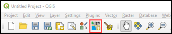
Select QGIS Desktop 3.34.3 from the Start Menu. The QGIS splash screen appears.
|
Step 2 |
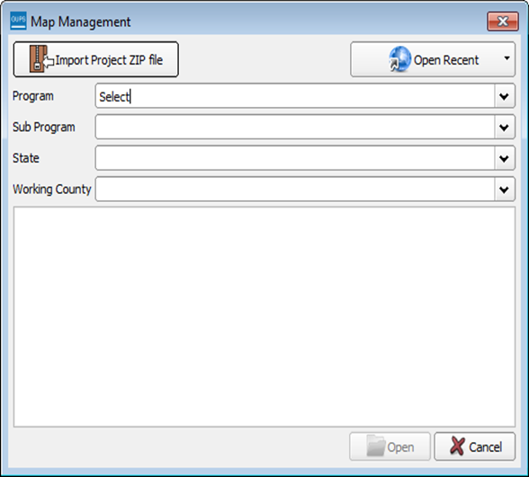
The Map Management window appears.
|
|
If the Map Management window does not appear, choose the Map Management button from the Standard toolbar (shown below highlighted by a red rectangle). If the Map Management button does not exist in the Standard toolbar, contact the SDRP Team at <geo.school@census.gov> for assistance.
|
Step 3 |
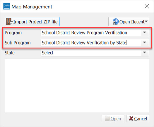
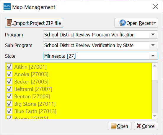
In the Map Management window, use the drop-down menu next to the Program field to select School District Review Program Verification and then select School District Review by State for the Sub Program field.
|
Step 4 |
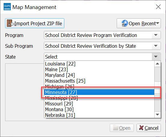
In the State field, use the drop-down menu to select a state. Use the scroll bar to move up and down the list of states. This example uses Minnesota.
|
Step 5 |
After selecting a state, GUPS refreshes the Map Management window and automatically highlights all available counties for the state of Minnesota. Select Open.
|
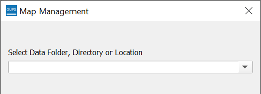
Step 6 |
The Select Data Folder, Directory or Location window opens.
|
|
GUPS only prompts for a data download location once per project. When a project has been closed and reopened, the shapefiles automatically load, even if no changes were made during the first session. |
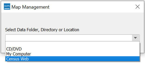
Step 7 |
A secondary Map Management window appears to select the data source. From this secondary Map Management window, choose Census Web to download the shapefile data layers with preset symbology and labels directly into GUPS.
|

Proceed to the next section for instructions on conducting the verification review.
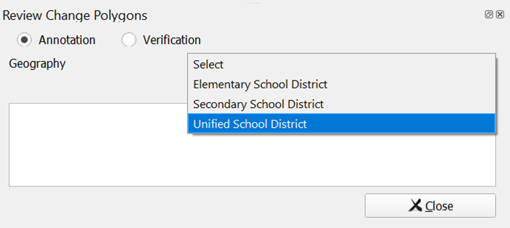
Verification involves reviewing the school district boundaries to ensure the Census Bureau accurately and completely captured the updates submitted by mapping coordinators. In GUPS, the Review Change Polygons tool is used to identify areas where updates were submitted. Follow the steps in Table 3 to verify the accuracy of the school district boundaries. Refer to the Annotation Phase respondent guide’s Review Change Polygons Tool section for additional details.
Table 3: Steps to Verify the Annotation Phase Updates with the Review Change Polygons Tool
Step |
Action and Result |
Step 1 |
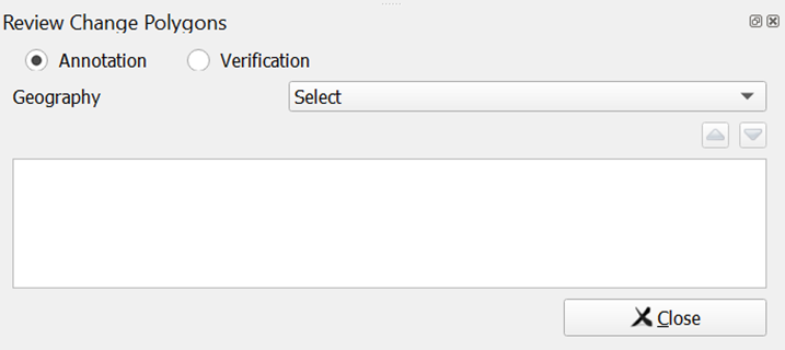
Select the Review Change Polygons tool from the SDRP toolbar.
The Review Change Polygons window opens.
|
|
The window includes two radio buttons: Annotation and Verification. Annotation is selected by default and is used to review the changes made during the Annotation Phase. To see changes made during the verification review, change the button to Verification. |
Step 2 |
From the Geography drop-down menu select the school district level to review. This example uses Unified School District.
|
Step 3 |
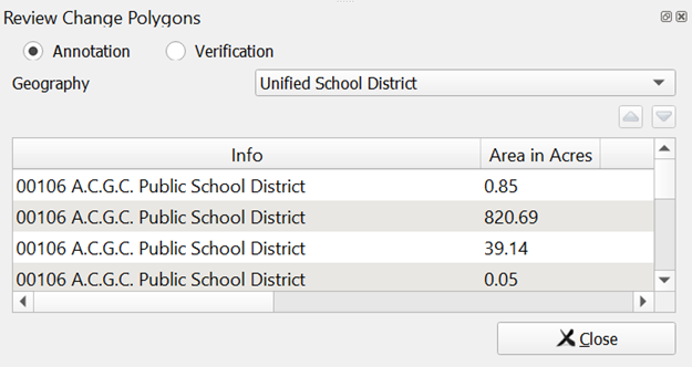
The Review Change Polygons window populates with a list of Unified School District updates from the Annotation Phase. Each record represents an update that added area.
|
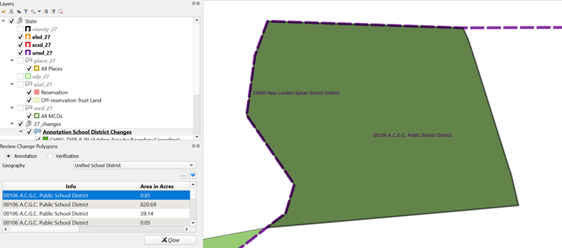
Step 4 |
Select a record from the list. The Map View zooms to the extent of the selected record.
Review the selected school district by panning or zooming around the boundary to confirm it accurately reflects the requested update from the Annotation Phase. |
Step 5 |
Review each record in the list. If updates were made to the other two types of school districts (Elementary School District and Secondary School District), change the Geography drop-down selection to review the next type of school district in the same manner described above. |
If the boundaries are correct and there are no discrepancies with the listing files, please notify the SDRP team at <geo.school@census.gov> of your agreement. If the boundaries do not reflect the updates submitted during the Annotation Phase or are otherwise incorrect and/or the listing files contain discrepancies, please contact the SDRP team at <geo.school@census.gov> or 301-763-1099 for further instruction.

![]()
| File Type | application/vnd.openxmlformats-officedocument.wordprocessingml.document |
| File Title | 2025SDRP_Verification_RespondentGuide |
| Subject | 2023 SDRP Verification Phase |
| Author | U.S. Census Bureau |
| File Modified | 0000-00-00 |
| File Created | 2024-09-14 |
© 2026 OMB.report | Privacy Policy