Information
Whale Alert.docx
Generic Clearance for Citizen Science and Crowdsourcing Projects
Information
OMB: 0648-0828
Whale Alert
https://www.whalealert.org/?utm_medium=email&utm_source=govdelivery
heading to the water?
see
as you follow your location on nautical charts, Whale Alert helps identify the whales you see.
report
sharing sightings on Whale Alert helps rescuers, researchers, and mariners reduce deadly vessel strikes.
save
whales face constant human threats - with Whale Alert, the power to save them is in your hands.


Vessel strikes are a leading cause of whale mortality.
Large whales are vulnerable to collisions with all vessel types, sizes, and classes throughout the world's oceans. As our waterways become increasingly congested, high-traffic areas often intersect key marine mammal habitats. In California, gray whales are the most commonly reported vessel strikes. Along the Atlantic coast, it's the critically endangered North Atlantic right whale. Regardless of location, these strikes are often deadly for whales and cause significant damage to vessels.
Luckily, we know the solution - slow vessels down! Public whale sightings submitted via Whale Alert help establish speed zones, warnings, and other measures to reduce vessel speeds and reduce risks to whales.

Humpback Whale
One of the most popular whales for whale-watching, the humpback is vulnerable to vessel collisions on both coastlines, where their migration and feeding habitats overlap with heavy vessel traffic (Photo: ©Vanessa Mignon).
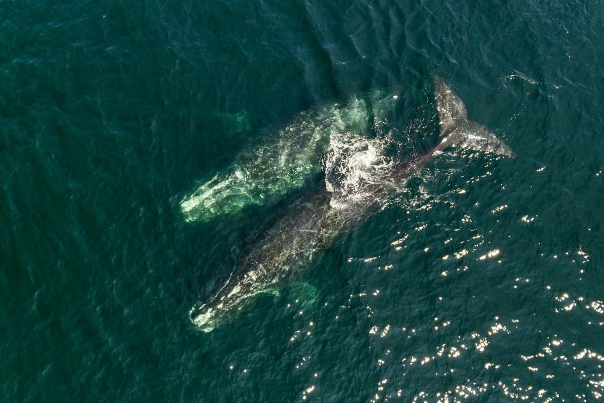
North Atlantic Right Whale
The North Atlantic right whale is one of the most critically endangered species in the world. With less than 360 individuals remaining, the lethal impact of vessel strikes is an extinction-level threat. IFAW-led research revealed that between 2003 and 2018, nearly 90% of right whale deaths were caused by vessel strikes and entanglement (Photo: ©Nick Hawkins).
View Right Whale Management Areas
On the East coast, mariners can view management areas for the endangered North Atlantic right whale including Seasonal Management Areas (SMAs) and Dynamic Management Areas (DMAs). Sightings reported via the app are automatically reported to the NOAA Right Whale Sighting Advisory System hotline where they can be viewed online via NOAA's Interactive Right Whale Sightings Google map
Whale Alert is a citizen science app where whale sightings are used to help prevent vessel strikes.
The Whale Alert app was launched in 2012 as a citizen science tool aimed at reducing the risk of vessel strikes. The app uses whale presence data including verified sightings, acoustic detections from buoys and gliders, and aerial surveys to display a user-friendly map based on nautical charts from country-specific government agencies.
Mariners, scientists, whale watchers, recreational boaters, and beachgoers alike can use their personal devices to easily share whale sightings with the Whale Alert team who then verify the information before posting it to the map in near-real time.
Public whale sightings submitted via Whale Alert help establish speed zones, warnings, and other measures to reduce vessel speeds and reduce risks to whales and mariners. Contributing to Whale Alert informs more accurate, evidence-driven administration of management areas to protect both whales and the livelihoods of people on the water.

Reporting Sightings
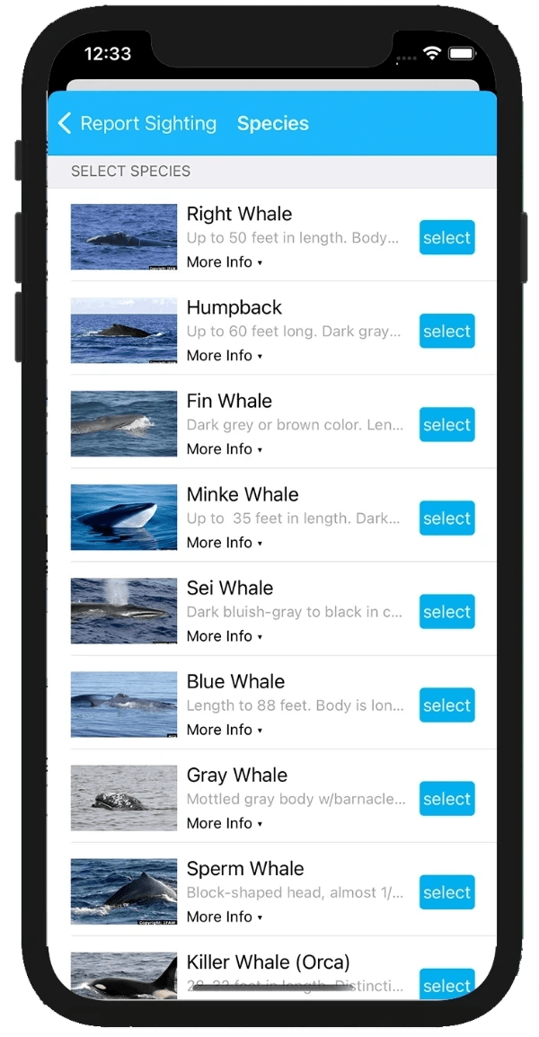
The Whale Alert app empowers users to report whale sightings via an accessible interface. Users simply select the ‘Report Sighting’ button at the bottom of the screen to share a sighting at their current location, and can then upload images, select a species, and leave comments. Each sighting includes species information, number of observations, date of sighting, and source of the sighting.
Sightings are reviewed prior to their addition to the map; however, regular users of the app can become trusted observers, helping to streamline the review process. If you are interested in becoming a trusted observer, contact info@whalealert.org.
Critically, Whale Alert includes the ability to report live, dead, or distressed whales and facilitates phone calls (where required) to direct a report to regional management professionals with the user's location, enhancing the survivability of whales in distress.
Sightings Support
Whale Alert makes it easy for the public, industry partners, and volunteer networks to log whale sightings in a simple-to-use interface. For those with less experience identifying whales, the app also provides an accessible whale identification guide.
Whale Alert automatically sends sightings to a central database which, in turn, is used by leading whale biologists and resource managers to better understand whale feeding and migration patterns and help establish dynamic management areas.
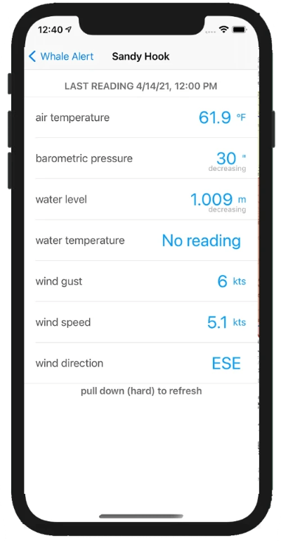
NOAA PORTS® data
Another feature specifically designed to help vessel operators is the inclusion of Physical Oceanographic Real-Time System (PORTS®) tide and weather data supplied by NOAA.
Where available, PORTS® adds an important situational awareness feature that helps large vessel operators gain the upper hand over a host of environmental conditions affecting their ability to act on whale protection measures.
Mariner Alerts
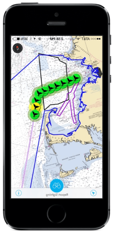
Whale Alert features several useful tools designed for mariners. Using built-in GPS technology commonly found in smartphones and tablets, the app "alerts" users with visual and auditory alerts when they enter active management zones. By doing so, Whale Alert makes it easier to navigate the evolving network of overlapping conservation zones and shipping lanes.
The current roster of zones is supplied by various national and state regulatory agencies including the National Oceanic and Atmospheric Administration (NOAA), Fisheries and Oceans Canada (DFO), Transport Canada, US National Park Service, the California Department of Fish & Wildlife, and the Oregon Division of Fish and Wildlife.
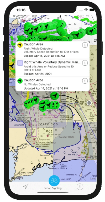
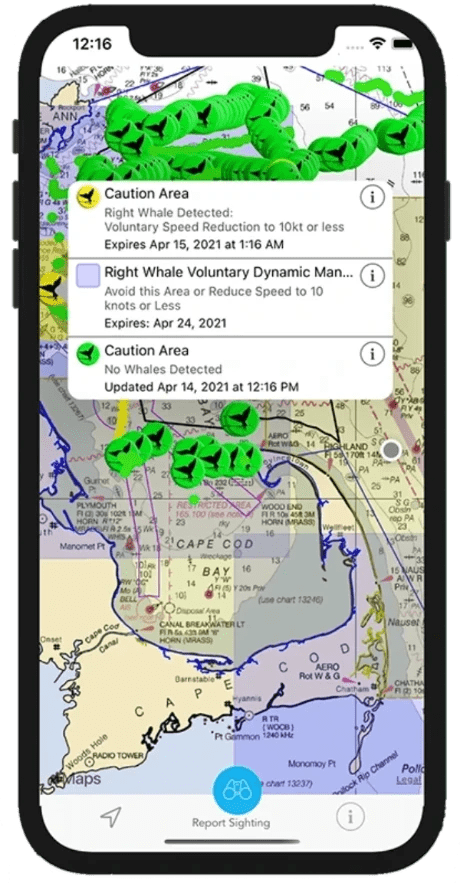
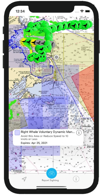
Alert Zones: Management Areas
Seasonal Management Areas (SMAs) are areas where NOAA requires vessels 65 feet in length or greater to travel at speeds of less than or equal to 10 knots. SMAs along the eastern seaboard of the US will appear as orange-colored displays. If a boat enters an active SMA, a pop-up will appear stating that the ship should be traveling at the regulated speed.
Dynamic Management Areas (DMAs) use sightings of multiple whales to trigger temporary, voluntary speed restrictions or advisory notices. DMAs will appear during designated time periods. A pop-up alert providing explanatory details is displayed when entering DMAs. Voluntary Slow Zones are also displayed.
Voluntary Areas to be Avoided (ATBA) are areas in key right whale habitats in US and Canadian waters that have been established for ships weighing 300 gross tons or greater.
Recommended Routes (RR) are paths produced by NOAA (and shown in the app) to help guide vessels through densely populated whale areas.

Alert Zones: Marine Protected Areas
Whale Alert includes US and Canadian National Marine Sanctuaries and other Marine Protected Areas (MPAs) that heavily regulate fishing or other vessel activities. You can tap on an area to learn more about what is regulated.
The bright colors (blue and red) correspond to the type and level of protection for marine life. To learn more about this important resource visit our partner ProtectedSeas who maintains these maps.
Alert Zones: Boston Harbor
Whale Alert uses a state-of-the-art acoustic detection system to warn mariners of the presence of endangered North Atlantic right whales in shipping lanes leading through NOAA’s Stellwagen Bank National Marine Sanctuary, and to and from Boston, Massachusetts. The system is based on buoys that use hydrophones, special software, and satellite communication to identify right whale calls and automatically relay information to mariners.
Within the app, yellow whale tails indicate that a right whale has been detected within the past 24 hrs and that NOAA recommends a speed of 10 knots or less through the area during that time period.
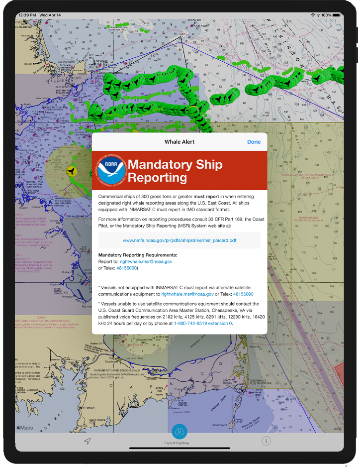
Mandatory Ship Reporting
NOAA's Mandatory Ship Reporting (MSR) requires commercial ships of 300 gross tons and greater to report in when entering designated right whale reporting areas along the US Atlantic Coast. When a ship enters an MSR area, a pop-up display will provide information on reporting procedures and remind the mariner to report to the US Coast Guard.
Whale Alert greatly simplifies the process by including the MSR notice directly within the app.
NOAA PORTS® data
Another feature specifically designed to help vessel operators is the inclusion of Physical Oceanographic Real-Time System (PORTS®) tide and weather data supplied by NOAA.
Where available, PORTS® adds an important situational awareness feature that helps large vessel operators gain the upper hand over a host of environmental conditions affecting their ability to act on whale protection measures.
Mariner Alerts
Whale Alert features several useful tools designed for mariners. Using built-in GPS technology commonly found in smartphones and tablets, the app "alerts" users with visual and auditory alerts when they enter active management zones. By doing so, Whale Alert makes it easier to navigate the evolving network of overlapping conservation zones and shipping lanes.
The current roster of zones is supplied by various national and state regulatory agencies including the National Oceanic and Atmospheric Administration (NOAA), Fisheries and Oceans Canada (DFO), Transport Canada, US National Park Service, the California Department of Fish & Wildlife, and the Oregon Division of Fish and Wildlife.
FAQs
Who is Whale Alert for?
EVERYONE! Whale Alert is free and designed to be used by anyone with access to download the app. Sightings can be logged by recreational boaters, whale watchers, ferry captains, cruise ship passengers, sailors, land-based observers, fishermen, dock workers - if you can see a whale, you can add your sighting in Whale Alert!
I'm a member of the public - why should I use Whale Alert?
If you're not already convinced, you should use Whale Alert because it is an invaluable tool for protecting whales, and one that you can contribute to regardless of training or prior knowledge. Sightings that you log into Whale Alert are sent to a database used to establish management areas. Providing your sighting shows biologists and resource managers where the whales actually are, so they can in turn determine the best areas for vessels to slow down. Over time, this data can be used to determine whale migration patterns, so more permanent measures can be taken to protect whales from vessel strikes in heavy traffic areas.
I'm a mariner - why should I use Whale Alert?
Whale Alert is not only a tool for protecting whales, but it is also a convenient tool for mariners to get near real-time updates on management measures, reporting requirements, and oceanographic conditions. We simplify the actions that you have to take in response to a whale sighting or entry to a management zone.
We've designed Whale Alert specifically with mariners in mind, and are open to comments on ways to improve the app for your use on the water! Contact us at info@whalealert.org.
Does Whale alert work with other sightings platforms?
Whale Alert isn't the only sightings platform developed to protect marine mammals. We contribute sightings to a number of other platforms, including:
NOAA Right Whale Database, which shares sightings with Whale Map
St. Lawrence Global Observatory
Point Blue Conservation through Whale Alert West Coast and NOAA partners
Acartia Collective in the Puget Sound Region
Whale Report & Alert System
Whale Safe
Logging a sighting on Whale Alert will provide data for use by other platforms and initiatives. After all, we all have the same goal - to save whales!
Take Action
Contribute data
Download the app and collect and submit observation data - every individual animal matters.
Donate
Donate to provide critical support for further development of technology, education, research, and outreach.
![]()
Become a trusted observer
If you are regularly on the water, contact us about becoming a trusted observer for Whale Alert.
![]()
Tell your community
Promote Whale Alert in your area using our outreach materials below.
| File Type | application/vnd.openxmlformats-officedocument.wordprocessingml.document |
| Author | Joe.I.Terry |
| File Modified | 0000-00-00 |
| File Created | 2023-10-04 |
© 2026 OMB.report | Privacy Policy