The Boundary and Annexation Survey (BAS)
The Boundary and Annexation Survey (BAS) & Boundary Validation Program (BVP)
13_RespondentGuide_PaperBAS_WorkingDraft_09_10_12
The Boundary and Annexation Survey (BAS)
OMB: 0607-0151
Boundary and Annexation Survey Respondent Guide: Paper |
Issued January 2013 |
|
|
|
|
|
|
This page is intentionally left blank
Table of Contents
1. Introduction to the Boundary and Annexation Survey (BAS) 2
1.2 Specific state arrangements and agreements 2
1.4 Key dates for BAS respondents 3
2.1 Forms included in the BAS package 4
3. Reviewing and Updating the BAS Maps 5
3.1 Maps included in the BAS package 5
3.2 General guidelines for reviewing and updating BAS maps 5
3.10 Geographic Corridors and offsets 23
3.11 County Review and Consolidations 27
3.12 PLSS……………………………………………………………………………….....28
3.13 New incorporations………………………………………………………………...…28
3.14 Disincorporations……………………………………………………………………..28
4. Signing the Updated Maps and returning the BAS Materials 29
Appendix 1: Paperwork Reduction Project 31
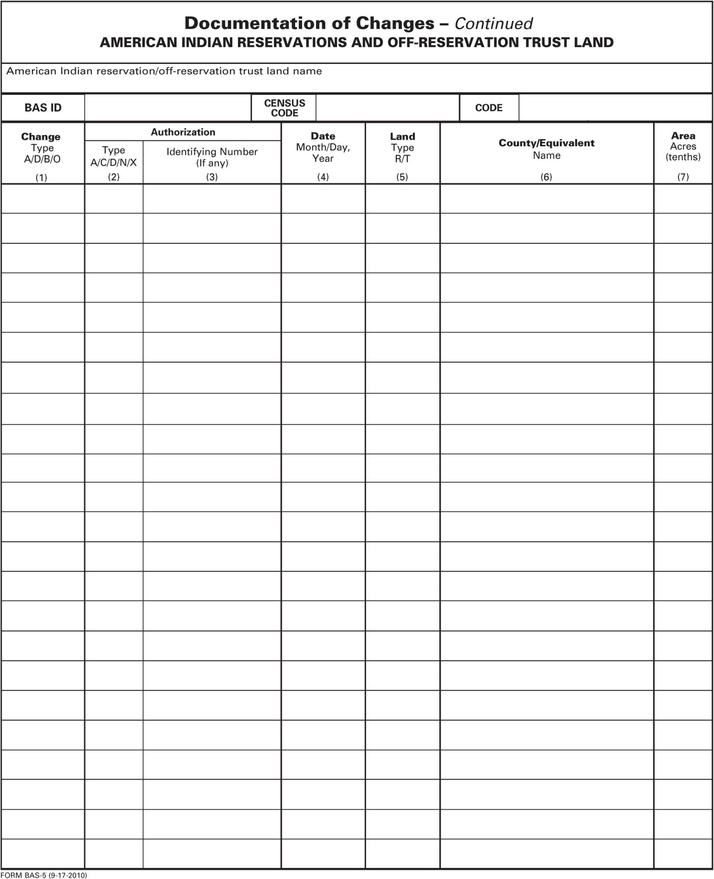
Appendix 2: Additional Copies of the Documentation of Changes forms 32
Appendix 3: MTFCC Codes…………………………………………………………………......36
The U.S. Census Bureau conducts an annual survey called the Boundary and Annexation Survey (BAS) to collect information about selected legally defined geographic areas, such as counties (and equivalent areas), incorporated places, minor civil divisions (MCDs), and federally recognized American Indian reservations (including off-reservation trust lands and tribal subdivisions). The BAS also provides an opportunity for participants to review the names and geographic relationships for these areas. Title 13, U.S. Census Code authorizes this survey.
The Census Bureau uses BAS information to provide a record for reporting the results of the decennial and economic censuses, and to support the Population Estimates Program and the American Community Survey. Maintaining correct boundaries and boundary-to-feature relationships through the BAS helps ensure that the appropriate population is assigned to each governmental unit (GU).
In compliance with the Office of Management and Budget Circular A-16, the BAS supports the Census Bureau’s spatial data steward responsibilities for the Federal Geographic Data Committee and the Geo.Data.gov website by updating the inventory and boundaries of GUs. In addition, the BAS is the source of up-to-date information on boundaries, codes, and names for the U.S. Geological Survey’s (USGS) National Map and the Geographic Names Information System, as well as the source for changes in the boundaries of incorporated places, minor civil divisions (MCDs), counties (and equivalent areas), and federally recognized American Indian Areas (AIAs), which include reservations and off-reservation trust lands.
The Census Bureau has established a number of arrangements or agreements with states for reporting boundary changes. Please visit the BAS program website at http://www.census.gov/geo/partnerships/bas.html or call (800) 972-5651 for information regarding state agreements.
If it comes to the Census Bureau’s attention that an area of land is in dispute between two or more jurisdictions, annexations or boundary corrections will not be made in Census Bureau products or data until the parties come to a written agreement, or there is a documented final court decision regarding the matter/dispute. If you have questions concerning this, please contact the Census Bureau Legal Office at 301-763-9844. For disputes involving tribal areas, the Census Bureau must defer to the Office of the Solicitor at the Department of the Interior for a legal opinion. Often complicated land issues require an extended period of time for resolution, and in those cases, the Census Bureau will retain the current boundary in the database until a legal opinion is issued by the Solicitor’s office.
All legal boundary updates received by March 1 of the survey year will be reflected in the Population Estimates Program and the American Community Survey. If the Census Bureau receives legal boundary updates by May 31, they will be included in BAS materials for the following year.
The last day to request materials for the first BAS deadline (updates to be reflected in the ACS) is February 15. The last day to request materials for the second BAS deadline (updates to be reflected in the next years BAS materials) is April 15. Any requests for paper materials made after these dates may not be received in time to meet the deadlines. Contact the Census Bureau by phone at 800-972-5651 or by email at geo.bas@census.gov.
There are four primary steps required to review and submit BAS materials to the Census Bureau. Detailed instructions for each step are provided in the guide.
STEP ONE: Complete the BAS forms
Answer all the questions on the BAS form and review all preprinted information. Confirm that the name and status of the governmental unit is correct and that the Highest Elected Official (HEO) or Tribal Chair (TC) and BAS contact information is accurate. Record all legal changes on the BAS form.
STEP TWO: Review the maps
Review boundaries and features for accuracy. If there are no changes to report, please return only the No Change postcard to the Census Bureau. The BAS form and maps should be returned only if there are corrections.
STEP THREE: Update the maps
Update maps with boundary changes (e.g., annexations), boundary corrections, and feature changes (e.g., roads). Please follow the specific instructions on updating maps.
STEP FOUR: Sign and return updated maps and BAS forms
Return the completed BAS form and updated map(s) using the pre-addressed envelope or return label by March 1st to:
U.S. Census Bureau
National Processing Center
ATTN: BAS Returns, Bldg 63A
1201 East 10th Street
Jeffersonville, IN 47132
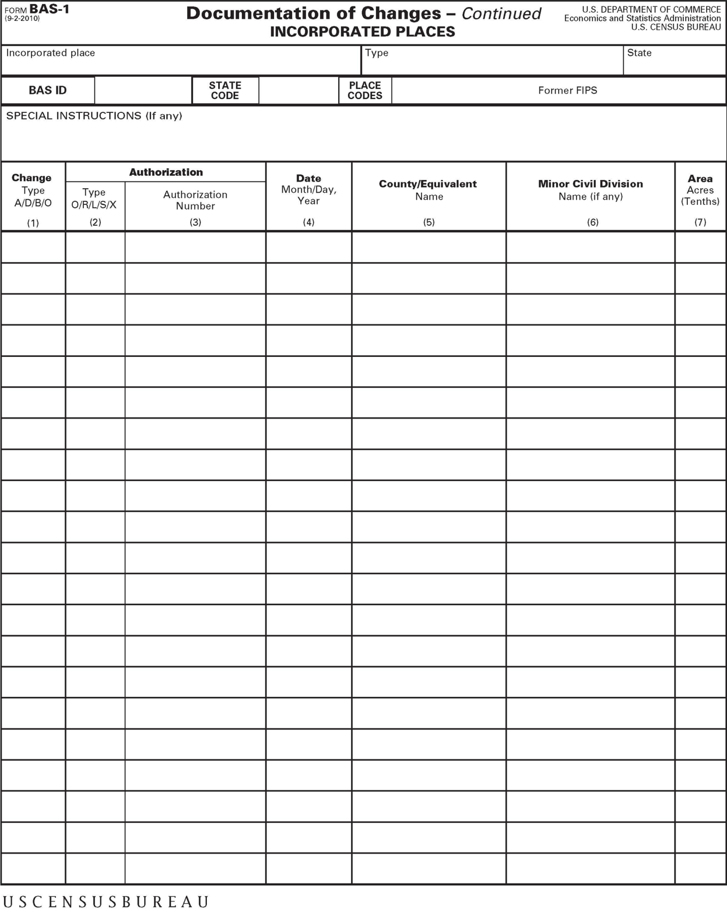
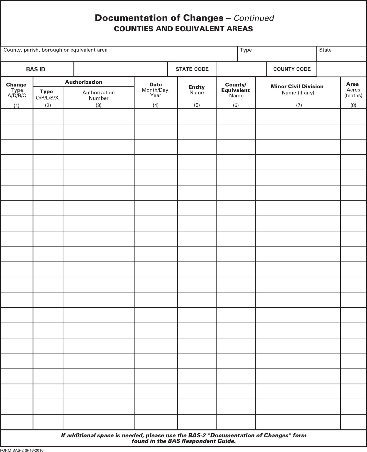
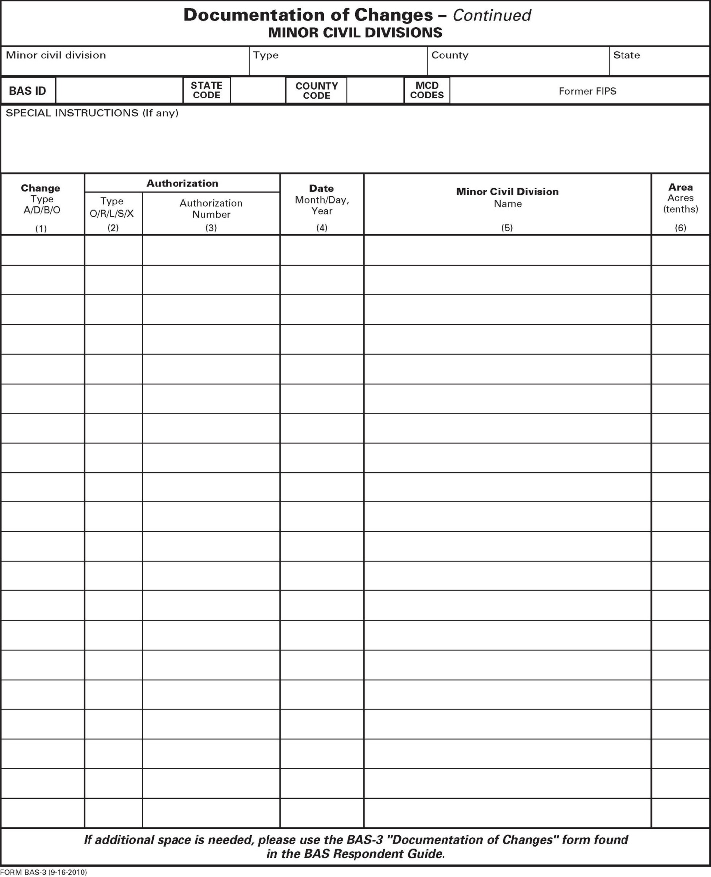
The forms in the BAS package should be used to verify legal names, legal status, contact information, previous legal boundary changes submitted to the Census Bureau, and to document any recent or missing legal boundary changes. There are four types of forms:
BAS-1 for Incorporated Places
BAS-2 for Counties and Equivalent Areas
BAS-3 for Minor Civil Divisions
BAS-5 for American Indian Reservations and Off-Reservation Trust Land
Name or type changes
Verify that the legal names and legal status of the governmental unit or AIA are accurate. Make any necessary corrections by crossing out the error and clearly printing the correct information. Provide an effective date for name, type, or status changes. County participants should verify the list of active and inactive entities within their counties.
Contact information
Verify that the Census Bureau has the most recent BAS, HEO, or TC contact information for the GU or AIA. Fill in any missing or incorrect information, including e-mail and fax. If the primary address of the BAS contact, HEO, or TC is a PO Box, provide the Census Bureau with a physical address that can be used for the delivery of maps. Contact changes or updates may also be provided to the Census Bureau throughout the year by email to geo.bas@census.gov.
Legal boundary changes
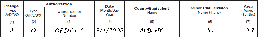
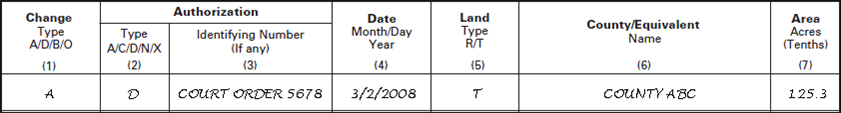
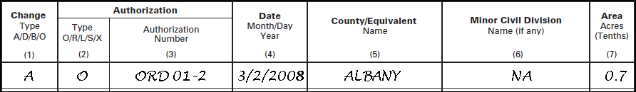
Record all legal boundary changes in the Documentation of Changes section of the BAS form. Include legal boundary changes that occurred prior to January 1 of the current survey year if they do not appear on the current BAS maps. Please include legal authorization, such as a local ordinance or resolution number, and the effective date of the legal action. If additional pages are needed to record legal changes, a copy of the Documentation of Changes is provided in the appendix.
Other changes
Please indicate if there are any boundary corrections or feature updates that need to be made on the BAS maps. This will assist the Census Bureau in identifying and accounting for any updates made to the maps.
The Census Bureau mails an index map showing the entire governmental unit or AIA, along with more detailed individual map sheets. Index maps are provided as a reference to help locate a map sheet. Governmental units and AIAs with more than 40 map sheets receive only an index map and the map sheets that show the legal boundary. Entities that require more than 40 boundary ring map sheets receive only the index map.
Requesting Additional Maps
If you only received an index map for a county, incorporated place, MCD, or AIA where boundary changes or feature updates need to be made, call (800) 972-5651 or email geo.bas@census.gov to request individual map sheet or a full set of maps. Do not make updates on the index map.
Colored pencils are provided in the package. The red pencil should be used to indicate legal boundary changes and non-legal boundary corrections for all counties, places, MCDs, and AIAs. The purple pencil should be used to indicate feature changes or corrections. The blue pencil should be used by AIAs to add or modify tribal subdivisions.
Compare the BAS maps to a local source for an entity (e.g., a local plat map, or a county assessor’s dataset). Update the map(s) if the boundaries shown do not correctly depict the boundaries in effect as of January 1st of the survey year.
You may also provide annexations and deannexations from previous years in addition to providing updates as of January 1st. However, the Census Bureau does require legal documentation when submitting these vintage legal updates.
The maps show boundaries for multiple legal and statistical boundaries. If an entity’s legal boundaries are coextensive with another boundary, the symbols on the map will alternate. In the figure below, the county shares a boundary with an incorporated place and CDP; therefore, the symbols on the map alternate between county, incorporated place, and CDP.
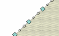
Example 3.2.1: The combined line represents a county, incorporated place and CDP boundary.
3.3 Census Bureau Geocoding
Geocoding is how the Census Bureau codes population to geographic entities. There are two primary methods of geocoding used by the Census Bureau. Both of these involve coding an address to a spatial polygon, but one uses GPS technology, while the other uses address ranges.
MAF structure point (MSP) geocoding: a field worker stands in front of a house or living quarters, and records the physical location with a GPS device (Example 3.3.1). Usually, the GPS point should fall very close to the front door of the house. However, since this is a field operation, real-world obstacles like locked fences, poor satellite reception, or even aggressive dogs might sometimes prevent the worker from gaining access to the front door. In these circumstances, the worker may have to take the GPS coordinate from the sidewalk or side of the road.
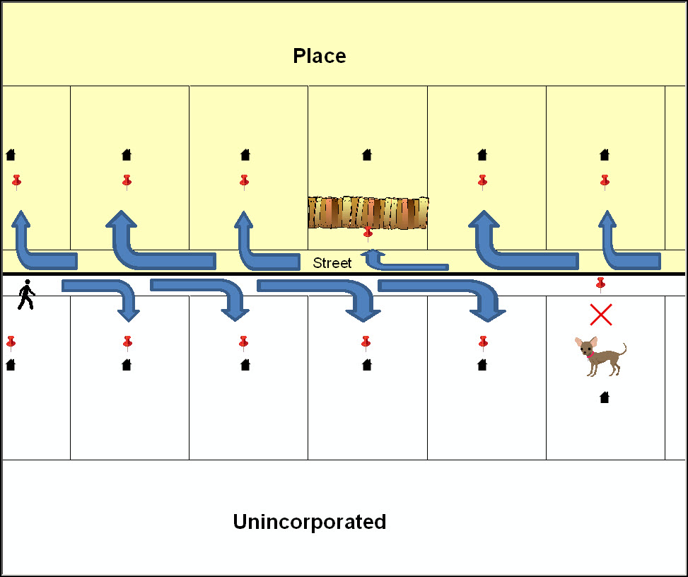
Example 3.3.1: MSP method of geocoding. Notice that it is occasionally not possible for the field worker to go all the way to the front door, due to unforeseen circumstances, like the fence or the dog shown above. Thus, the MSP (represented here by the red pins) can sometimes fall within the road or the road right-of-way.
Address Range geocoding: when no MSP is available, the Census Bureau codes houses and living quarters according to a potential range of addresses associated with the adjacent stretch of road (Example 3.3.2).
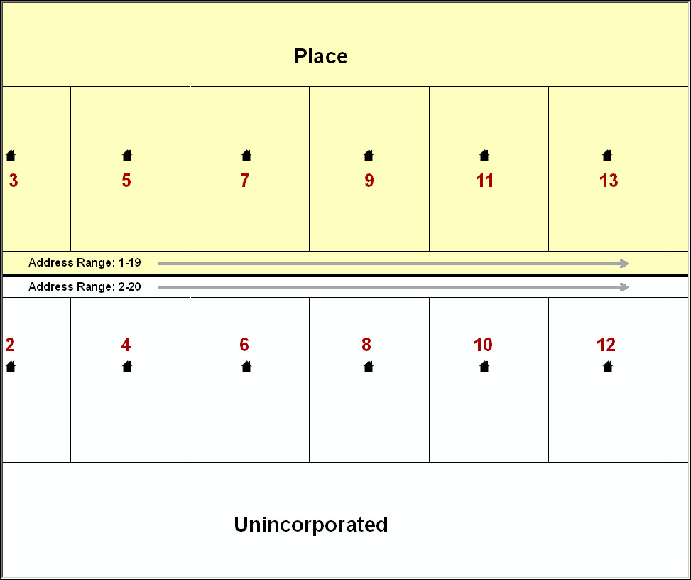
Example 3.3.2: Address Range method of geocoding. When it is not possible to collect an MSP, houses are geocoded according to their placement along a range of potential addresses along that road. Since the address is being related to the road, boundaries placed on front lot lines will lead to mis-geocoding unless an offset flag is used
While the two methods of geocoding differ greatly, both rely heavily on the integrated nature of the MAF/TIGER database, and are affected by the way streets and boundaries are represented in relation to one another. This interdependence between streets, boundaries, and geocoding means that Census Bureau representations of legal boundaries may sometimes differ from other representations (e.g., in local or state GIS). This is especially true regarding geographic corridors and offsets that follow road right of ways (or the front lot lines of parcels). In both of the examples above, delineating a boundary along the front lot line will tend to increase the risk of incorrect geocoding. Using the road centerline as a boundary is much safer.
When completing a BAS submission in which a road or road right-of-way is owned or maintained by a place or AIA but the adjacent housing is not, the respondent should use the centerline of the road (not the front lot-line) as the boundary whenever possible. If local or state law requires that the front lot line boundary be used, the respondent must explicitly designate the polygon(s) between the road centerline and the front-lot boundary as a corridor or an offset (see Section 3.10 of this document for more details).
3.4 Legal Boundary Changes
Legal boundary changes are the result of legal actions (e.g., annexations), and are the primary goal of the BAS. AIA Legal documentation (e.g., statute, federal court decision, trust deed) must accompany all AIA legal boundary changes, while legal boundary change submissions from incorporated places, MCDs, and counties must provide an authorization number, such as a resolution or ordinance number1.
The following figures illustrate the correct way to draw legal boundary changes on BAS maps.
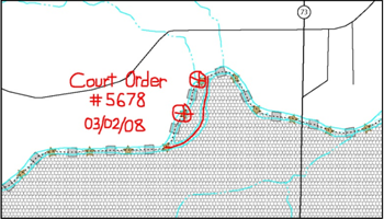
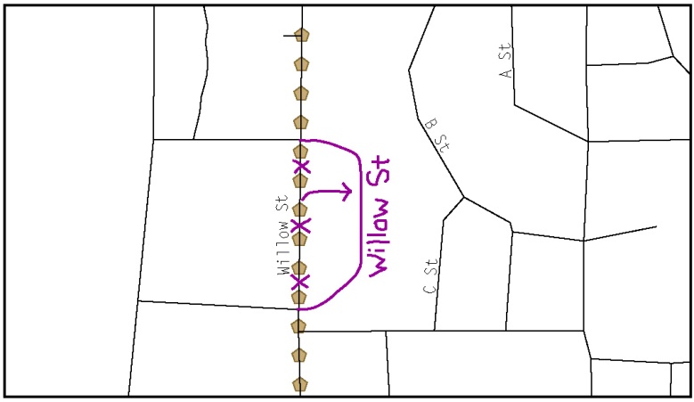
Using the red pencil provided, cross out the portion of the boundary that is no longer current with a string of Xs.
Draw the new boundary line(s) ensuring the boundary is closed.
Add the ordinance number or other legal identifier of the action authorizing the change, along with the effective date of each annexation or deannexation that is drawn on the map.
Record all legal changes in the Documentation of Changes section of the BAS form.
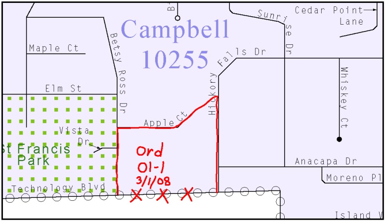
Example 3.4.1: Correctly annotating a legal boundary change with the red pencil and recording the change in the Documentation of Changes section of the BAS form
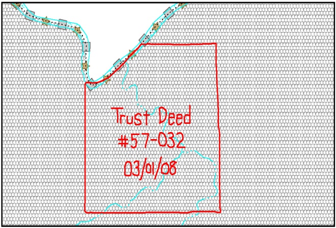
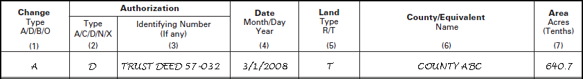
Example 3.4.2: Correctly annotating an AIA trust land and recording the change in the Documentation of Changes section of the BAS form. The original reservation is not deleted and therefore does not require a string of X’s.
Boundary changes involving coincident features
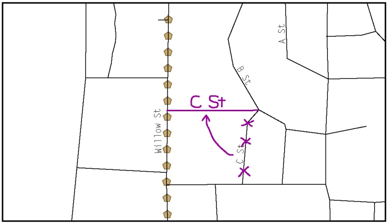
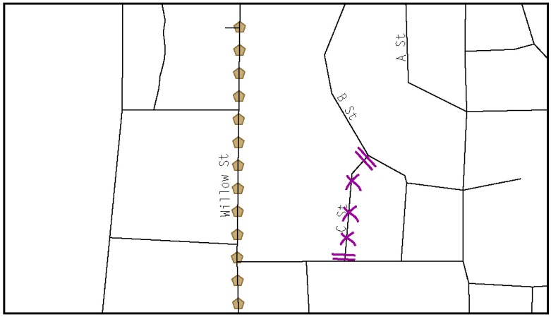
The following figures illustrate how to adjust a boundary that is coincident with (i.e., follows exactly) a feature, such as a river or street. In this case, the feature location is correct, but the boundary location is incorrect.
Using the red pencil, cross out the portion of the boundary that is no longer current using a string of Xs inside circles.
Draw the updated boundary.
Add the authorization number or other identifier of the action authorizing the change along with the effective date of each addition or deletion.
Record all legal changes in the Documentation of Changes section of the BAS form.
If both the boundary and feature need to be moved, cross out the incorrect boundary with a string of red “Xs” and then draw a red line representing the new location of the boundary and road.
Example 3.4.3: Annotating a legal boundary change coincident with a river feature, where the river location does not change, but the boundary does. The legal change is also recorded in the Documentation of Changes.
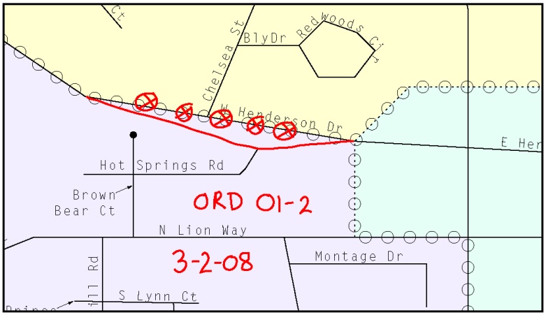
Example 3.4.4: Annotating a legal change to an incorporated place boundary coincident with a road feature, where only the boundary moves to the new location. The street feature location is correct, but the boundary location is incorrect.
Example 3.4.5 illustrates how to make a correction to the boundary where an associated feature moves along with the boundary. If these changes are the result of an annexation or deannexation, include the authorization number and effective date.
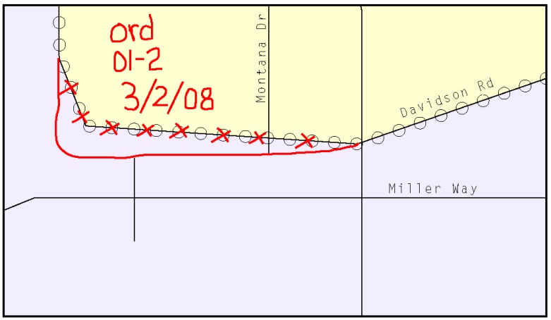
Example 3.4.5: Annotating a legal change to both an incorporated place boundary and an associated coincident road feature, where both the street and the boundary should be moved to a new location. The legal change is recorded in the Documentation of Changes.
3.5 Boundary Corrections
A boundary correction is the adjustment of a boundary to correct an error in how the Census Bureau depicts an existing boundary. Boundary corrections should follow the general shape of the existing boundary. Legal documentation is not required when submitting a boundary correction to the Census Bureau. Boundary corrections also do not need to be reported on the BAS form.
The following figure illustrates how to complete a boundary correction.
Using the enclosed red pencil, cross out the incorrect boundary with a string of Xs.
Add a line showing the correct boundary.
Print the letters BC inside the change to identify the update as a boundary correction rather than a legal change.
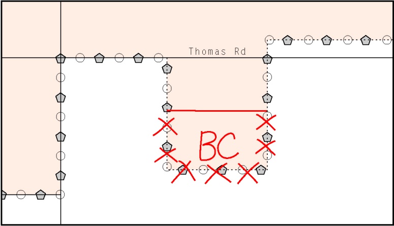
Example 3.5.1: Annotating a boundary correction to an incorporated place boundary
3.6 Tribal subdivisions
The Census Bureau considers any type of unit of self-government or administration in tribal areas as a tribal subdivision. A tribe may submit only one type of subdivision, even if it has more than one type of distinct administrative area that could qualify as a tribal subdivision (e.g., tribal election districts, tribal water districts, or health service areas with different boundaries). Tribal subdivisions can be considered either active (A) or inactive (I):
Active subdivisions are defined as having a functioning government, with elected officials, that provides programs and services
Inactive subdivisions have no functioning government or elected officials and receive services solely from the tribe
Some examples of areas submitted as tribal subdivisions are:
Areas used by a tribe for the election of tribal government officials (e.g., districts or precincts used for the election of tribal council members)
Areas used by a tribal government for tax purposes
Areas used by a tribal government for the provision of general services or specified services, such as:
water districts
health service areas
emergency service delivery areas (911, fire, and/or police), or
grazing districts or range units
Historical or traditional areas recognized by a tribal government
Sub-reservation tribal community governments
Keep the following criteria in mind when defining tribal subdivisions:
Tribal subdivisions should cover all, or most, of a tribe’s land base
The delineation of tribal subdivisions is restricted to the area contained within reservations and/or associated off-reservation trust lands
There is no minimum population threshold for a tribal subdivision
A tribal subdivision may be noncontiguous
Tribes may designate only one type of tribal subdivision. If a tribe has more than one level of tribal subdivision within its land base, the Census Bureau recommends delineating subdivisions corresponding to the lowest geographic level (those geographic areas containing the smallest area) of the tribe’s administrative hierarchy
Tribal subdivisions should not be based solely on land ownership or other cadastral areas, nor should they consist of divisions based on the U.S. public land survey system of townships, ranges, and sections, if these areas have no governmental or administrative function for a tribe
The following descriptions can be appended to chosen subdivision names (e.g., Red Rock Community):
District
Community
Area
Chapter
Segment
Administrative Area
Addition
County District
Delineating new tribal subdivisions
If this is the first time tribal subdivisions are being provided to Census:
Using the blue pencil, add the boundaries on the BAS map(s).
Note: If a full set of BAS maps has not been sent, please request them by calling your Regional Office.
Each tribal subdivision must be labeled on each map sheet with its name (e.g., “District 3,” “Arlee District,” “White Rock Chapter,” “Parmelee Community”).
Record the names, type, and status of each subdivision in the Tribal Names and Status Documentation section of the BAS-5 form.
If a tribal subdivision boundary follows a visible feature such as a stream, road, or fence line, be sure to indicate that on the BAS map. Add the visible feature the boundary follows if it is not already shown on the map.
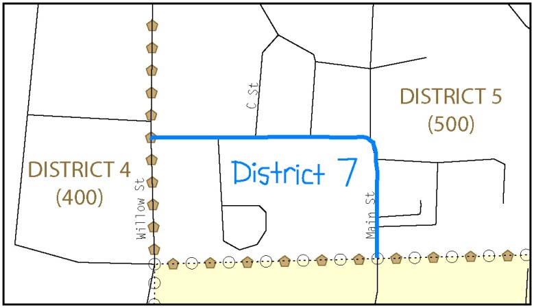
Example 3.6.1: Depicting a new tribal subdivision and recording the information in the Tribal Names and Status Documentation section of the BAS form
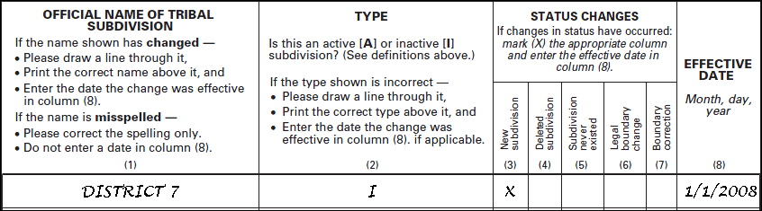
Updating existing tribal subdivisions
If tribal subdivisions were delineated during a prior survey, they are symbolized on the enclosed BAS maps by a dashed pentagon-shaped gold line.
Before adding/or revising tribal subdivision boundaries on the enclosed map(s):
Using the red pencil, note any changes to the boundary of the land base on the map(s).
Using the blue pencil, add and/or revise the boundaries of the tribal subdivisions on the enclosed BAS map(s).
Note: The names and types (active or inactive) of tribal subdivisions are listed in the Tribal Names and Status Documentation section of the BAS-5 form. This information should be reviewed and updated.
Tribal subdivision documentation
New tribal subdivisions and name changes to existing tribal subdivisions require documentation, regardless of whether they are being delineated for the first time, or being added to those previously reported. This documentation should be in the form of a tribal resolution or a tribal constitution. Include a copy of this documentation with your BAS maps and BAS-5 form when returning these materials to the Census Bureau.
Corrections to the Census Bureau’s depiction of tribal subdivision boundaries or names do not require documentation.
If there are any questions or if additional maps are needed, contact the local Regional Office’s Geography staff at the telephone number shown on the enclosed BAS-5 form.
3.7 Feature modifications
The primary purpose of the BAS is to collect legal boundary information. However, feature (e.g. streets, rivers) updates and modifications that occur near or coincident with a legal boundary should be submitted through the BAS. Feature modifications that are internal to the boundary of an incorporated place, county or MCD will be accepted, but are not required as part of the BAS.
Modifying locations of streets
The following figures illustrate how to correct the location of a street feature:
Using the purple pencil, cross out the incorrect feature location with Xs.
Draw the feature in the correct location.
Print the name of the feature along the length of the feature (as shown in the figures below).
Example 3.7.1: Modifying a street feature location.
In this example the street location moves, but the boundary does not.
Example 3.7.2: Modifying a street feature location that does not affect a boundary.
The Census Bureau recently completed a nationwide program to improve the positional accuracy of all streets and other features that appear in the Census Bureau’s MAF/TIGER database. It is not necessary to make small positional corrections on the BAS maps; correct only those streets that are incorrectly located, mislabeled or distorted. Additionally, new streets may be added, and nonexistent streets may be deleted.
Adding, deleting and naming streets
When adding missing streets, new streets, and alternate street names:
Use the purple pencil to draw the feature and its name on the map.
If possible, provide the address range for any new streets.
Provide the MTFCC code (Appendix 5) for all new streets (Example 3.6.3).
Alternate street names can be written in parentheses below the primary street name.

Example 3.7.3: Adding an MTFCC code when adding a new street.
Note: Due to the difficulty of showing multiple names for the same street, only the primary street name is shown on BAS maps. Please note that, even though alternate street names are not shown on the maps, they do exist in our database. For example, US Hwy 30 may be locally known as Main St., but on the BAS map, only US Hwy 30 will be displayed; however, within our database, both names are listed. If you have reported an alternate street name in the past, you do not have to report it to us again.
When correcting street names:
Using the purple pencil, draw a line through the incorrect street name.
Print the correct street name along the feature.
Example 3.7.4: Correcting a street name
Note: If an area of the map is too congested to add all feature names, number each feature and list this number and the corresponding feature name in the map margin or in an uncongested spot close to the feature’s actual location (see below). Do not repeat numbers on a map sheet.

Example 3.7.5 Adding street name features in a congested area when deleting streets:
Note: Delete street features only if they are nonexistent, or impassable. Do not delete a street because the local jurisdiction is not responsible for maintaining it.
Using the purple pencil, mark the beginning and end of the base feature to be deleted with hatch (//) marks perpendicular to the feature as shown below.
Cross out what is to be removed using a string of Xs.
Example 3.7.6: Deleting a street feature
When naming streets:
Using the purple pencil, label any unnamed streets on the maps.
Label any unnamed private roads with PR.
Examples of private roads are driveways and unnamed roads in commercial or industrial parks.
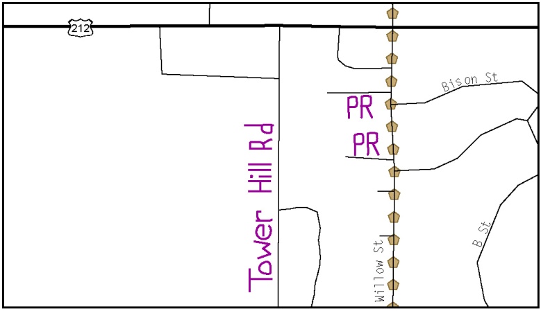
Example 3.7.7: Adding unnamed road features
Cul-de-sacs and traffic circles
When adding a cul-de-sac or circle:
Using the purple pencil, draw the feature.
Cul-de-sacs are entirely paved, and should be drawn as a solid dot.
Circles have an area of unpaved ground within them, and should be drawn as an unfilled circle.
Print the name of the associated street leading to the cul-de-sac or circle.
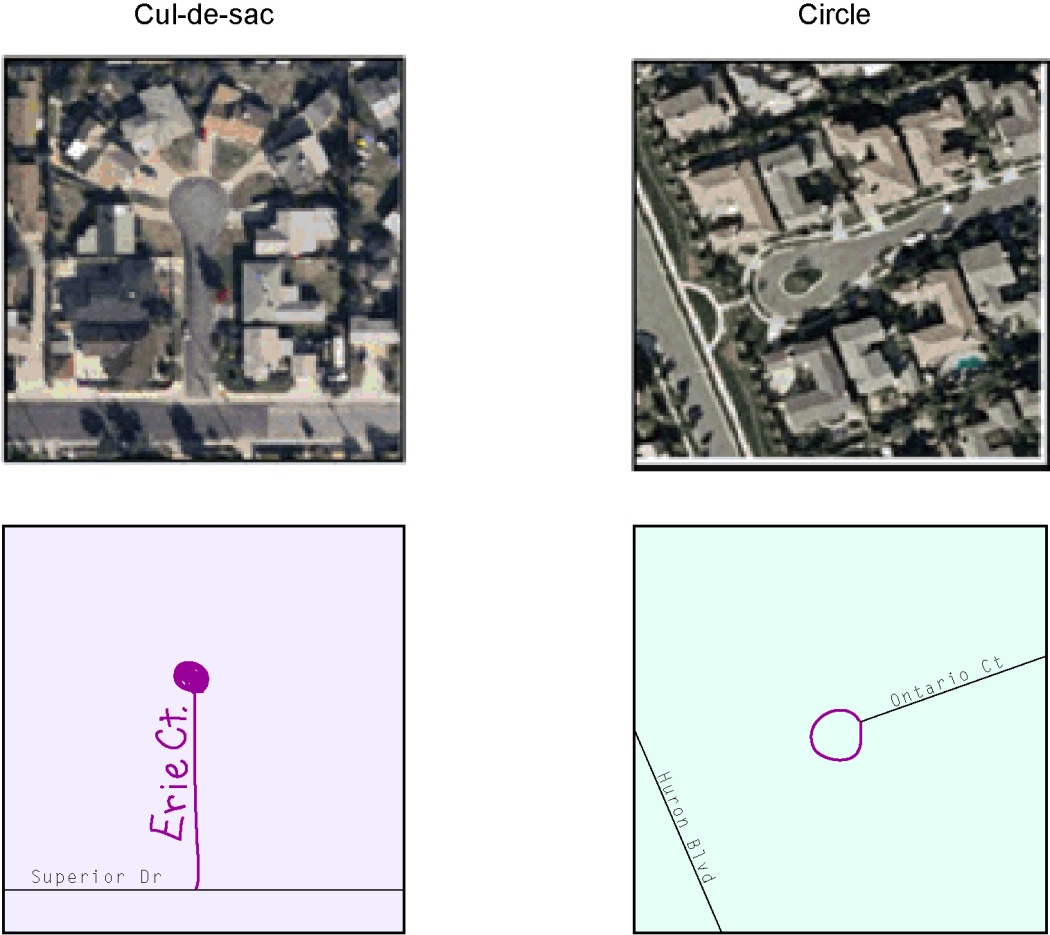
Example 3.7.8: Adding cul-de-sac and circle features
Annotating address range breaks
Addresses are stored in the Census Bureau spatial database as potential address ranges. The BAS maps show the break in the potential address range created where a street is bisected by a boundary. These address range breaks are shown because it is important that the Census Bureau assign the correct addresses to each governmental unit.
Note: Some streets on the BAS maps do not display address breaks due to space considerations.
Add address ranges on both ends of the street only if one of the following circumstances exists:
A road where house numbers, street names and/or addresses were added or deleted
A street was added that crosses a boundary
The address ranges created by a boundary are incorrect on the map.
When adding address ranges:
Using the purple pencil, add in the address ranges. Provide the lowest or highest addresses that could be assigned to a road where the road intersects a boundary.
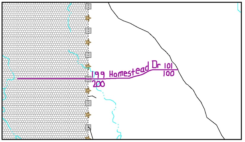
Example 3.7.9: Adding a street feature and annotating with the name and address breaks
3.8 Point Landmarks
BAS maps display a select number of point landmarks (e.g., mountain peaks). Point landmarks can be updated through the BAS, but are not required.
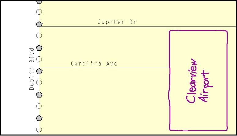
Acceptable point landmark feature updates include mountain peaks or summits, libraries, city halls, community centers and police stations. Airports, parks, schools, golf courses, museums, and cemeteries can be submitted as point landmarks or area landmarks.
Features that contain residences or private business should not be added as point landmarks or area features (e.g. hotels, campgrounds, retirement homes, farms).
The BAS maps also include select point landmarks (e.g. airports, cemeteries, summits) taken from USGS topography maps and the USGS Geographic Names Information System. These landmarks represent the official federally recognized name and will not be removed or updated unless it is verified by the USGS.
When adding a point landmark:
Using the purple pencil, place a solid dot at the location of the point landmark.
Print the name of the landmark next to the dot.
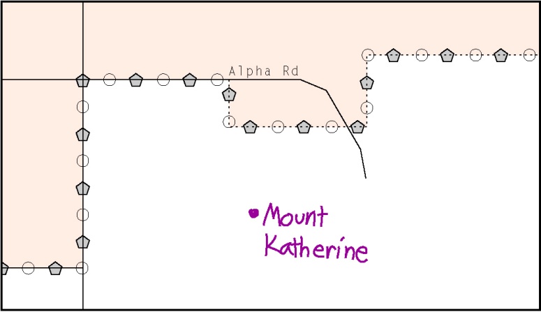
Example 3.8.1: Adding a point landmark
3.9 Area Landmarks
The BAS maps display a select number of area landmarks (e.g., lakes). Like point landmarks, area features can be updated through the BAS, but are not required.
Acceptable area landmark updates include water bodies, swamps, quarries, national parks or forests. Airports, parks, schools, golf courses, museums, and cemeteries can be submitted as area landmarks or point landmarks.
Features that contain residences or private business should not be added as point landmarks or area features (e.g. hotels, campgrounds, retirement homes, farms).
When adding an area landmark:
Using the purple pencil, draw the area landmark boundary in the correct location.
Print the name of the landmark inside or next to the feature.
Example 3.9.1: Adding an area landmark
3.10 Geographic corridors and offsets
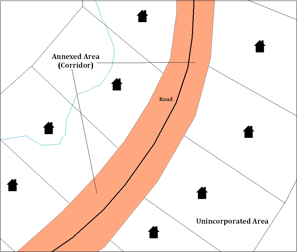
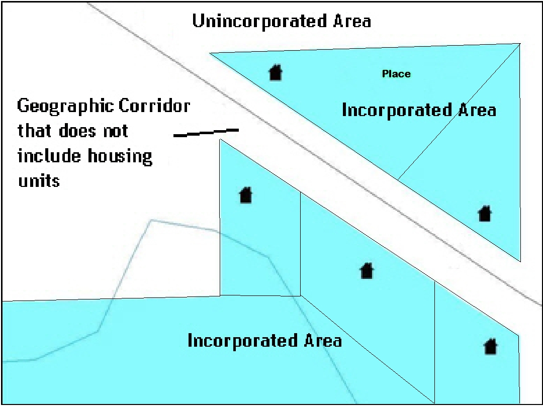
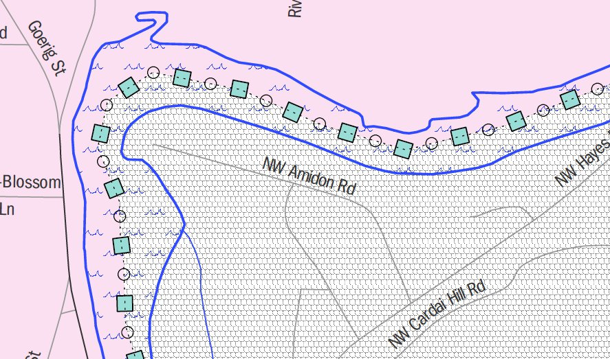
A geographic corridor is an area that only includes road surface and right-of-way and does not contain any structures addressed to either side of the street. A geographic offset is an area claimed by a geographic entity that is only on one side of a road and does not include structures addressed to that side of the road.

Example 3.10.1: The image on the left illustrates a geographic offset, designated by red diagonal lines. The offset is part of the incorporated place (green area). However, the dwelling units are counted outside of the incorporated place. The image on the right illustrates a geographic corridor (Co Rd, south of Samples Rd) and a geographic offset (Co Rd, north of Samples Rd). The geographic corridor and offset are both part of the incorporated place (yellow area), but the dwelling units are not.
Geographic Corridors
A geographic corridor is an area that includes only the road right-of-way and does not contain any structures addressed to either side of the street. Example 3.9.2 shows a corridor that has been created where the incorporated place or AIA owns the right-of-way, and wishes for that ownership to be displayed on the Census Bureau’s maps, but the housing units are not included in the incorporated place or AIA (shown in color). Without a corridor, the housing units along this road would be incorrectly geocoded into the incorporated place or AIA. Thus, if it is important to the place or AIA that its ownership and/or maintenance of the road and/or its rights-of-way be displayed on Census’ maps, a geographic corridor should be created. However, the Census does not require places and AIAs to report rights-of-way: maintaining geographic corridors in a nationwide database is not essential to the mission of the Census Bureau and the right-of-way should only be included if it is crucial to the place or AIA, or if state or local laws require it.
Example 3.10.3 shows a case where the right-of-way belongs in the unincorporated area, while the housing units are included in the incorporated place (shown in color). While depicting this corridor may be important for local purposes, it is not relevant for Census Bureau tabulations because no house can be built in a road right-of-way. This type of corridor should not be included in a BAS response.
Please note that the Census Bureau does not require places or AIAs to display rights-of-way or road maintenance corridors that do not contain or potentially contain housing or population. If local or state law does not require depiction of these geographic features, the Census Bureau prefers that they be left off BAS submissions. If it is necessary for the place or AIA to depict them, they must be submitted as a geographic corridor.
Example 3.10.2 Example 3.10.3
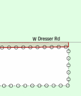
Geographic corridors can be provided to the Census Bureau if the centerline representation results in addresses being assigned to the wrong entity. However, geographic corridors should only be created if the addresses along the street do not belong to your governmental unit. To indicate a geographic corridor on your map, use the red pencil to draw a line on each side of the road. Mark the beginning and end of each line with perpendicular hatch marks. Write the letters “GC” beside each line (Example 3.10.4). To remove a geographic corridor or offset, use the red pencil to mark the beginning and end of the corridor or offset with perpendicular hatch marks and write “remove GC.”
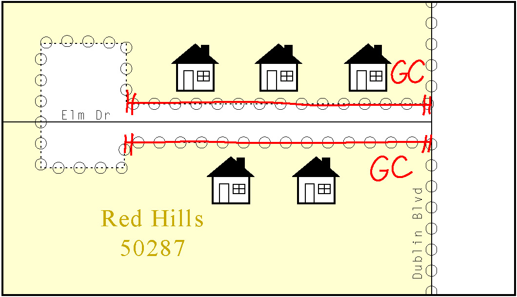
Example 3.10.4: To indicate a geographic corridor on your BAS return, use the red pencil to draw a line on each side of the road. Mark the beginning and end of each line with perpendicular hatch marks. Write the letters “GC” beside each line.
Geographic offsets
The Census Bureau is aware that many governments base their legal boundaries on cadastral (parcel-based) right-of-way mapping. Census maps are based on spatial data that is topologically integrated, which makes maintenance of geographic offsets inefficient. Delineating an entity boundary on the centerline wherever applicable will help to establish more accurate population counts. If a boundary is on the front lot line adjacent to a road on the map, the Census Bureau strongly prefers that the boundary be delineated on the road centerline already shown on the map. If a boundary is on the rear or side lot line, then it should be depicted as such. If it is unclear whether a particular line is a front lot line or something else, please contact the BAS team for assistance. Generally, if a house or other building could not conceivably be built in the area between the potential line and the centerline of the road, then the line can be considered a front lot line.
Example 3.10.5, below, shows a situation in which the place boundary is along the front lot line. In this example, the respondent must either delineate the boundary on the road centerline, or create an offset. In Example 3.10.6, the place boundary is on the rear lot line, so the respondent should not delineate it on the road centerline or create an offset; instead, the respondent should delineate a new edge that actually follows the rear lot line.
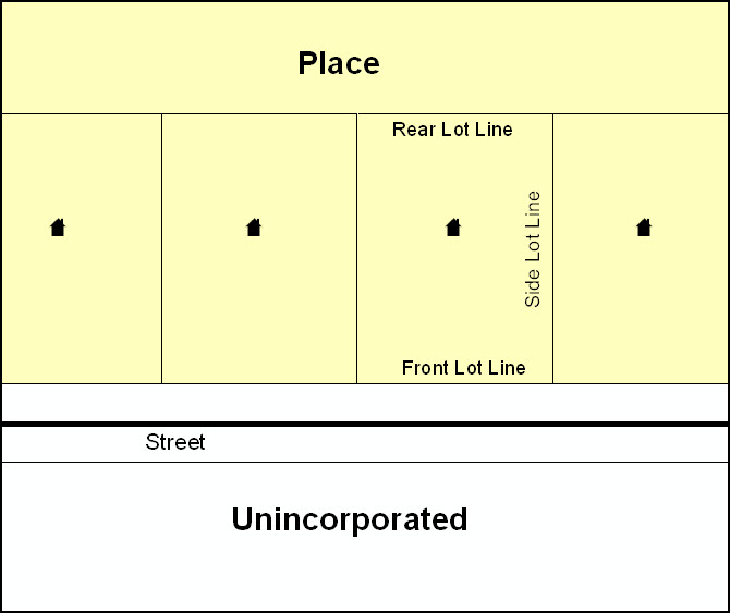
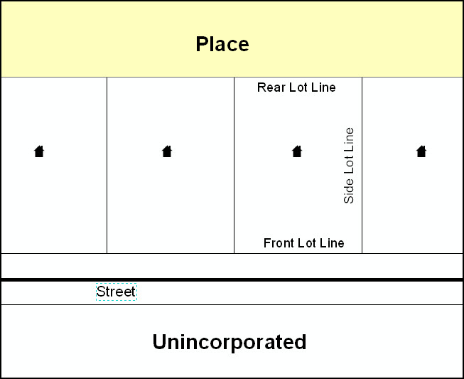
Example 3.10.5 Example 3.10.6
To indicate a geographic offset on your map, use the red pencil to draw a line on parallel to the road, along which you want the offset to be created. Mark the beginning and end of the line with perpendicular hatch marks. Write the letters “OFF” on the side of the road where the geographic offset exists (Example 3.10.7).
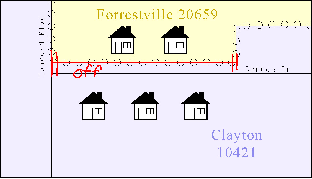
Example 3.10.7: This example shows the proper method of depicting a geographic offset on a paper BAS submission.
3.11 County Review and Consolidations
Counties receive boundary information from the Census Bureau for all governmental units within their county boundary. Counties should review the names and legal status of active and inactive incorporated places and MCDs found on page 3 of the BAS-2 form.
Active entities are defined as having a functioning government, with elected officials, that provides programs and services.
Inactive entities have no functioning government or elected officials, receive services solely from the county, and should be reviewed by the county during BAS.
Although it is not required, counties may update boundaries for incorporated places and MCDs on the county BAS maps. The Census Bureau encourages counties to establish consolidation agreements with local governments in order to consolidate resources, reduce the burden on local governments, and avoid duplication of work. Under a county consolidation agreement, the county is responsible for reporting boundary changes to the Census Bureau. Participating local governments would no longer receive an annual BAS package. One hundred percent participation is not required and governments may opt out of the agreement at any time. Contact the Census Bureau at geo.bas@census.gov for more information on participating in a county consolidation.
3.12 Public Land Survey System (PLSS)
Boundaries are often based on nonvisible features, such as Public Land Survey System (PLSS) lines (i.e. township, section, range lines, etc.). The Census Bureau is currently working on a program through which PLSS lines can be incorporated into the MAF/TIGER database. If any of your entity’s existing or new boundaries are known to follow PLSS lines, you should designate that on your BAS submission by writing “PLSS” in red pencil next to (and parallel to) the appropriate boundary segments. In areas where the Census Bureau has obtained accurate PLSS shapefiles, we will then be able to compare these lines to those shapefiles and ensure accurate placement of the boundary.
3.13 New incorporations
Newly incorporated places should provide the Census Bureau:
A copy of the official new incorporation papers, including date of incorporation.
A map indicating the boundaries of the new incorporation.
Contact information for the highest elected official and a contact for the BAS.
3.14 Disincorporations
Disincorporated entities should provide the Census Bureau with a copy of the official papers of disincorporation, including the effective date.
For each map sheet that has changes, fill in the Signature Box on one copy of the map:
Print your name, your position, your telephone number, and the date.
Sign your name in the Signature area.
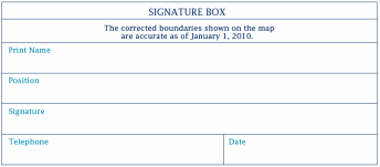
Example 4.1: BAS paper map Signature Box
Use the postage-paid envelope to return the set of signed maps and the BAS form to the Census Bureau. If after reviewing the BAS forms and maps, it is determined that there are no changes to report, sign the No Change postcard and return it to the Census Bureau.
Note: If the No Change post card is sent in, keep or destroy the maps and forms, do not return them to the Census Bureau.
Appendices
Appendix 1: Paperwork Reduction Project
The U.S. Census Bureau estimates that the BAS review will take most respondents from 1 to 8 hours to complete. This includes the time needed to read the instructions, assemble materials, organize and review the information, and report any needed changes. This estimate is based on 80 percent of all areas having few or no changes. However, for areas with many changes it may take 20 hours or longer to complete the survey. Please send comments regarding this burden estimate or any other aspect of this collection of information, including suggestions for reducing this burden to:
Paperwork Project 0607-0151
U.S. Census Bureau
4600 Silver Hill Road
Room 3K138
Washington, DC 20233
Or you may e-mail comments to:
paperwork@census.gov
Note: Use Paperwork Project 0607-0151 as the subject.
Please include a copy of your message addressed to:
geo.bas@census.gov
Appendix 2: Additional Copies of the Documentation of Changes forms
Appendix 3: MTFCC Codes
MTFCC Codes
MTFCC Code |
MTFCC Description (Short) |
MTFCC Description (Long) |
C3022 |
Mountain Peak or Summit |
Prominent elevation rising above the surrounding level of the Earth's surface |
C3023 |
Island |
Area of dry or relatively dry land surrounded by water or low wetland (archipelago, atoll, cay, hammock, hummock, isla, isle, key, moku, rock) |
C3024 |
Levee |
Natural or manmade embankment flanking a stream (bank, berm) |
C3026 |
Quarry (not water-filled), Open Pit Mine or Mine |
Place or area from which commercial minerals are or were removed from the Earth; not including oilfield |
C3027 |
Dam |
Water barrier or embankment built across the course of a stream or into a body of water to control and (or) impound the flow of water (breakwater, dike, jetty) |
C3061 |
Cul de sac |
A street that is closed at one end with a circular turnaround area and only one outlet |
C3062 |
Traffic Circle |
A circular intersection allowing for continuous movement of traffic at the meeting of roadways |
C3066 |
Gate |
A movable barrier across a road |
C3067 |
Toll booth |
A structure or barrier where a fee is collected for using a road |
C3070 |
Tower/beacon |
A manmade structure, higher than its diameter, generally used for observation, storage, or electronic transmission |
C3071 |
Lookout Tower |
A manmade structure, higher than its diameter used for observation |
C3072 |
Transmission Tower including cell, radio and TV |
A manmade structure, higher than its diameter used for electronic transmission |
C3073 |
Water Tower |
A manmade structure, higher than its diameter used for water storage |
C3074 |
Lighthouse Beacon |
A manmade structure, higher than its diameter used for transmission of light generally to aid in navigation |
C3075 |
Tank/Tank Farm |
A manmade structure(s), higher than its diameter used for liquid (other than water) or gas storage |
C3076 |
Windmill Farm |
A manmade structure(s) used to generate power from the wind |
C3077 |
Solar Farm |
A manmade structure(s) used to generate power from the sun |
C3078 |
Monument or Memorial |
A manmade structure to educate, commemorate, or memorialize an event, person, or feature |
C3079 |
Boundary Monument Point |
Material object placed on or near a boundary line to preserve and identify the location of the boundary line on the ground |
C3080 |
Survey Control Point |
Point on the ground whose position (horizontal or vertical) is known and can be used as a base for additional survey work |
C3081 |
Locality Point |
This feature represents points that identify locations and names of unbounded localities e.g., crossroads, community names, names from the Geographic Names Information System (GNIS). |
C3088 |
Landfill |
A disposal facility at which solid waste is placed on or in the land |
H2025 |
Swamp/Marsh |
A poorly drained Wetland, fresh or saltwater, wooded or grassy, possibly covered with open water (bog, cienega, marais, marsh, pocosin) |
H2030 |
Lake/Pond |
A natural body of inland water (backwater, lac, lagoon, laguna, pond, pool, resaca, waterhole) |
H2040 |
Reservoir |
An artificially impounded body of water (lake, tank) |
H2041 |
Treatment Pond |
An artificial body of water built to treat fouled water |
H2051 |
Bay/Estuary/Gulf/Sound |
A body of water partly surrounded by land (arm, bight, cove, inlet) |
H2053 |
Ocean/Sea |
Large body of salt water (gulf, ocean) |
H2060 |
Gravel Pit/Quarry filled with water |
A body of water in a place or area from which commercial minerals Were removed from the Earth |
H2081 |
Glacier |
A body or stream of ice moving outward and down slope from an area of accumulation; an area of relatively permanent snow or ice on the top or side of a mountain or mountainous area (ice field, ice patch, snow patch) |
H3010 |
Stream/River |
A linear body of water flowing on the Earth's surface (anabranch, awawa, bayou, branch, brook, creek, distributary, fork, kill, pup, rio, river, run, slough) |
H3013 |
Braided Stream |
A body of water flowing on the Earth's surface that is separated into multiple channels |
H3020 |
Canal, Ditch or Aqueduct |
A manmade waterway used by watercraft or for drainage, irrigation, mining, or water power (ditch, lateral) |
K1100 |
Housing Unit Location |
|
K1121 |
Apartment Building or Complex |
|
K1122 |
Rooming or Boarding House |
|
K1223 |
Trailer Court or Mobile Home Park |
|
K1225 |
Crew-of-Vessel Location |
|
K1226 |
Housing Facility/Dormitory for Workers |
|
K1227 |
Hotel, Motel, Resort, Spa, Hostel, YMCA, or YWCA |
|
K1228 |
Campground |
|
K1229 |
Shelter or Mission |
|
K1231 |
Hospital/Hospice/Urgent Care Facility |
One or more structures where the sick or injured may receive medical or surgical attention (infirmary) |
K1232 |
Halfway House/Group Home |
|
K1233 |
Nursing Home, Retirement Home, or Home for the Aged |
|
K1234 |
County Home or Poor Farm |
|
K1235 |
Juvenile Institution |
|
K1236 |
Local Jail or Detention Center |
|
K1237 |
Federal Penitentiary, State Prison, or Prison Farm |
|
K1238 |
Other Correctional Institution |
|
K1239 |
Convent, Monastery, Rectory, Other Religious Group Quarters |
|
K1241 |
Sorority, Fraternity, or College Dormitory |
|
K1251 |
Military Group Quarters |
|
K2100 |
Governmental |
|
K2110 |
Military Installation |
This feature represents areas owned and/or occupied by the Department of Defense for use by a branch of the armed forces, including the Army, Navy, Air Force, Marines, Coast Guard, and include state owned areas for the use of the National Guard. |
K2146 |
Community Center |
|
K2165 |
Government Center |
|
K2167 |
Convention Center |
|
K2180 |
Park |
This feature represents parklands defined and administered by Federal State and Local governments. |
K2181 |
National Park Service Land |
National Park Service Land |
K2182 |
National Forest or Other Federal Land |
National Forest or Other Federal Land |
K2191 |
Post Office |
An official facility of the U.S. Postal Service used for processing and distributing mail and other postal material |
K2193 |
Fire Department |
|
K2194 |
Police Station |
|
K2195 |
Library |
|
K2196 |
City/Town Hall |
|
K2197 |
Mixed Use/Other Non-residential |
|
K2300 |
Commercial Workplace |
|
K2361 |
Shopping Center or Major Retail Center |
|
K2362 |
Industrial Building or Industrial Park |
|
K2363 |
Office Building or Office Park |
|
K2364 |
Farm/Vineyard/Winery/Orchard |
Farm/Vineyard/Winery/Orchard |
K2366 |
Other Employment Center |
|
K2400 |
Transportation Terminal |
|
K2424 |
Marina |
|
K2432 |
Pier/Dock |
|
K2451 |
Airport or Airfield |
A manmade facility maintained for the use of aircraft (airfield, airstrip, landing field, landing strip) |
K2452 |
Train Station, Trolley or Mass Transit Rail Station |
|
K2453 |
Bus Terminal |
|
K2454 |
Marine Terminal |
|
K2455 |
Seaplane Anchorage |
|
K2456 |
Airport - Intermodal Transportation Hub/Terminal |
|
K2457 |
Airport - Statistical Representation |
|
K2458 |
Park and Ride Facility /Parking Lot |
|
K2459 |
Runway/Taxiway |
|
K2460 |
Helicopter Landing Pad |
|
K2500 |
Other Workplace |
|
K2545 |
Museum, Visitor Center, Cultural Center, or Tourist Attraction |
|
K2561 |
Golf Course |
|
K2564 |
Amusement Center |
|
K2582 |
Cemetery |
A place or area for burying the dead (burial, burying ground, grave, memorial garden) |
K2586 |
Zoo |
|
L4010 |
Pipeline |
|
L4020 |
Powerline |
|
L4040 |
Conveyor |
|
L4110 |
Fence Line |
|
L4121 |
Ridge Line |
|
L4125 |
Cliff/Escarpment |
A very steep or vertical slope (bluff, crag, head, headland, nose, palisades, precipice, promontory, rim, rimrock) |
L4130 |
Point-to-Point Line |
|
L4140 |
Property/Parcel Line (Including PLSS) |
|
L4165 |
Ferry Crossing |
|
P0001 |
Nonvisible Linear Legal/Statistical Boundary |
|
P0002 |
Perennial Shoreline |
|
P0003 |
Intermittent Shoreline |
|
P0004 |
Other non-visible bounding Edge (e.g., Census water boundary, boundary of an areal feature) |
|
R1011 |
Railroad Feature (Main, Spur, or Yard) |
Rail feature refers to a line of fixed rails or tracks that form railways or railroads, spurs, and rail yards. They are used for the transport of passengers and goods. |
R1051 |
Carline, Streetcar Track, Monorail, Other Mass Transit Rail |
Carline, Streetcar Track, Monorail, and other mass transit refer to various forms of rail transport that has one or more than one track on which monorails or streetcars run. These tracks are typically in urban areas. |
R1052 |
Cog Rail Line, Incline Rail Line, Tram |
Cog Rail Line, Incline Rail Line are railways with a special toothed rack rail or rack mounted on the railroad ties between the running rails. The trains are fitted with one or more cog wheels that mesh with this rack rail. This allows the trains to operate on steeply inclined slopes. A Tram is a cable car, especially one suspended from an overhead cable, or a wheeled vehicle that runs on rails and is propelled by electricity. |
S1100 |
Primary Road |
Primary Road |
S1200 |
Secondary Road |
Secondary Road |
S1400 |
Local Neighborhood Road, Rural Road, City Street |
Local Neighborhood Road, Rural Road, City Street |
S1500 |
Vehicular Trail (4WD) |
Vehicular Trail (4WD) |
S1630 |
Ramp |
Ramp |
S1640 |
Service Drive usually along a limited access highway |
Service Drive usually along a limited access highway |
S1710 |
Walkway/Pedestrian Trail |
Walkway/Pedestrian Trail |
S1720 |
Stairway |
Stairway |
S1730 |
Alley |
Alley |
S1740 |
Private Road for service vehicles (logging, oil fields, ranches, etc.) |
Private Road for service vehicles (logging, oil fields, ranches, etc.) |
S1750 |
Private Driveway |
Private Driveway |
S1780 |
Parking Lot Road |
Parking Lot Road |
S1820 |
Bike Path or Trail |
Bike Path or Trail |
S1830 |
Bridle Path |
Bridle Path |
S2000 |
Road Median |
Road Median |
Table A5: Select MTFCC Codes
Appendix 4: Reading a Map
Scales
A map is a paper or digital representation of an area. Naturally, the map is always smaller than the area it represents, so nearly all maps are equipped with a scale, which depicts the ratio of distance on the map to the actual distance on land. The scale can be designed any number of ways, but two of the most common scales are ratio scales (Figure A6.1), which describe a ratio between the map and the real world (e.g., 1:24,000), and bar scales, which depict that relationship graphically by displaying how much a certain distance on the map represents in the real world (Figure A6.1). In other words, if a map has a ratio scale of 1:24,000, it means that one inch on the map represents 24,000 inches on the ground. (This works with any unit of measurement, so long as the unit being used on the map is the same as – or properly converted from – the unit being depicted on the ground.) Often a map will have both types of scale.
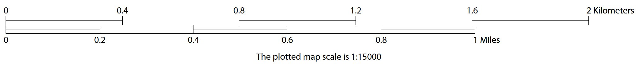
Figure A.6.1: The map from which this scale was taken has a ratio scale of 1:15,000. The bar scale shows distances in kilometers and miles.
A bar scale will often be a set length (e.g., one inch), and/or represent a set distance (e.g., one mile). You can use the bar scale to determine distance on your map by using a ruler. Simply place the ruler on the map to determine the distance on the map; then place the ruler along the bar scale, which will show how much that distance represents on the ground.
Maps that display a small area, but with a relatively large amount of detail, are considered large-scale maps (see Figure A6.2). A map that displays a large area, but shows less detail, is called a small-scale map (see Figure A6.3). This is because the representative fraction of a large-scale map (e.g., 1/7,500 or 1:7,500) is a larger fraction than that of a small-scale map (e.g., 1/250,000 or 1:250,000).
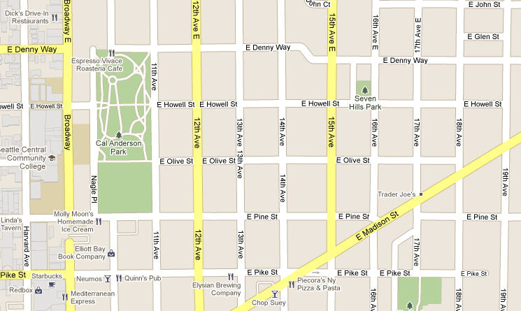
Figure A6.2: A large-scale map shows a greater amount of detail; this example displays streets, parks, churches and restaurants.
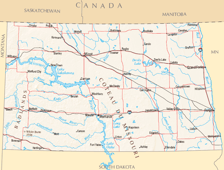
Figure A6.3: A small-scale map shows a large area, but with a small amount of detail.
Compass Rose
All maps should have some sort of diagram depicting at least one – but sometimes all – of the cardinal directions (north, south, east, and west) that the map reader can use to orient the map. This diagram is sometimes called a compass rose (see Figure A6.4). A compass rose can have any number of designs, and north can be shown in any direction on the map, but most maps are oriented with north at the top of the map. It is important to check the compass rose when beginning to read a map, in order to determine the direction in which the map is oriented (i.e., which direction is at the top of the map).

Figure A6.4: Compass Rose
Legend
Because a map is a graphic representation of a real-world area, naturally it is necessary, and convenient, to symbolize real-world features with representative symbols. These symbols can take any form, so long as they are consistent within any individual map. In order to describe what each symbol means, most maps have a legend (see Figure A6.5, below). The legend is typically located on the side or bottom of the map – they can be anywhere, so long as they do not obstruct the integral parts of the map. Typically, the legend will have a small example of each symbol (e.g. a line, or a picture of a tent), and next to the symbol, in text, a brief description of what is being depicted (e.g. “road”, or “campground”).
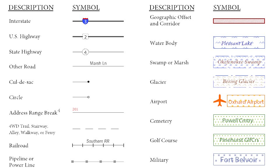
Figure A6.5: A legend describes what each symbol means
Sometimes a map needs to depict multiple features concurrently. This is because some lines are the boundaries of multiple geographies at the same time (i.e. a county boundary can also be a city boundary, a voting district boundary, and even a highway or river). Such instances can be depicted in various ways, but Census Bureau maps depict coincident lines by alternating the symbols for each type of line as shown in Figure A6.6 below. In other words, if a line is both a county boundary (symbolized by a series of squares) and a city boundary (a series of circles), that boundary will be depicted as a series of alternating squares and circles for the length of the concurrency.

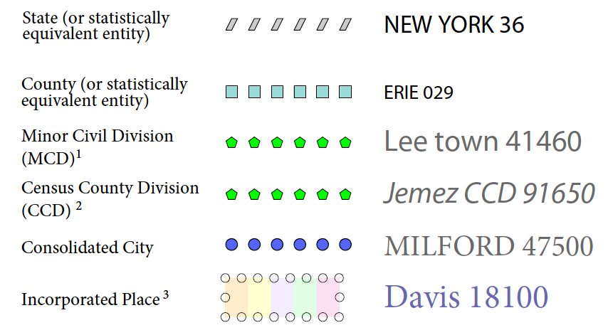
FigureA6.6: In this case, the city and the county boundaries are coincident, and run through the middle of the river.
In situations where higher-level geographies (e.g. national, state, county, or county subdivisions) coincide, the Census Bureau’s maps display only the symbol of the highest-ranking of these boundaries. In other words, if a particular boundary is shared by both a state and county, only the symbol representing the state boundary will be displayed.
Index Maps
In order to decide which map you need to use for your BAS submission, it is necessary to view the entity as a whole, and choose the correct parent map sheet based on its location within the entity. You can do this by referring to the index map (Figure A6.7), a relatively small-scale map that shows the entire entity, and the location and number of all parent map sheets within that entity. Each parent map sheet has a numerical locator which differentiates it from the other parent map sheets associated with that entity. The numbering begins with the northern and western-most parent map sheets, and continues left-to-right, in much the same pattern as words in a book. By referring to the index map, you can then determine which parent map sheet(s) you need to use for your BAS submission, and then access it based on its number on the index map.
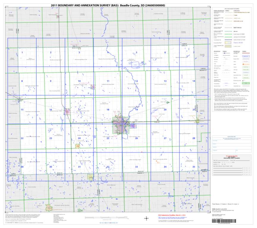
Figure A6.7: The Index Map sheet shows the location of all parent map sheets and inset map sheets within an entity.
The index map is not appropriate for BAS submissions. Its purpose is as a reference or index of parent maps, and it will not be accepted as a BAS submission.
Inset Maps
In some instances, in highly congested areas, even a parent map sheet provides insufficient detail for BAS purposes. In such cases, rather than using a parent map, the area is depicted within an inset map (Figure A6.10). This refers to a map with a very large scale, so that it displays a smaller area than the parent map sheet, but with greater detail. On the index map, an inset map is represented by a green outline, and is assigned a number preceded by a letter (i.e. A1, A2, B1, etc.), as shown in Figure A6.9 on the next page. Inset maps are only found in areas with a large number of features, and as such are used less often than parent maps.
F
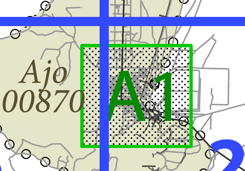
igure
A6.9: An inset map as it is displayed on the index map
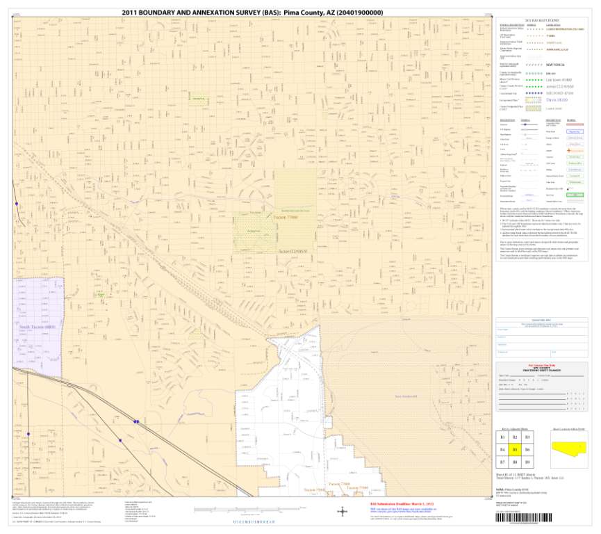
Figure A6.10: Inset maps show areas of relative congestion at a large scale, allowing a greater amount of detail.
Parent Maps
Many entities2, such as incorporated places and counties, are too large to be shown on a single map; that is, the scale is too small to allow the necessary details for BAS updates. Thus, it is necessary to separate the entity into sections, each of which has its own map, called the parent map sheet3 (Figure A6.11). Thus, a single entity is often represented with numerous map sheets, with each parent map sheet showing a small section of the entity. Each parent map is assigned a number, beginning with the number one and increasing progressively for each additional parent map sheet (i.e. 1, 2, 3, 4, etc.). In this way, viewing and editing map sheets becomes more manageable, and it becomes possible to depict an area with the level of detail necessary to make changes or challenges. In most instances, the parent map is the one that should be used for BAS submissions.
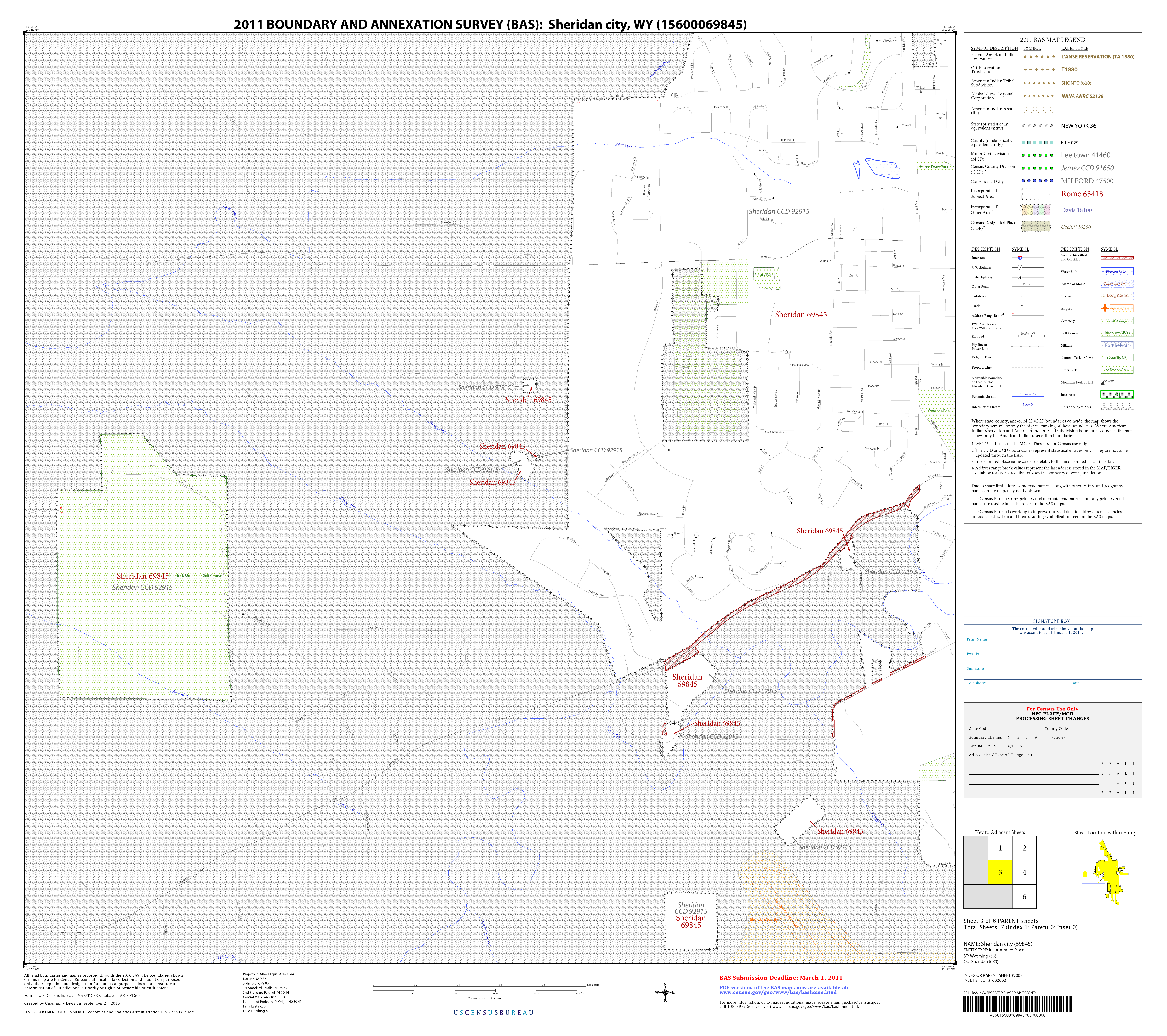
Figure A6.11: The parent map sheet shows a section of an entity at a relatively large scale.
In the bottom right-hand corner of the parent map sheet, there is a key to the parent map sheet’s location in relation to adjacent map sheets as shown in Figure A6.11 above. A larger example of this key is shown in Figure A6.12 on the next page. This way, if you need to refer to an adjacent map sheet, you can quickly determine which one you will need.
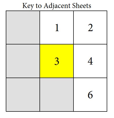
Figure A6.12: The key to adjacent sheets shows where the parent map sheet lies in relation to adjacent sheets.
Next to the key to adjacent sheets, there is a small outline of the entire entity (the inside of which is colored yellow), and a blue outline of the parent map sheet. This key displays the location of the map sheet in relation to the entity as a whole as is shown in Figure A6.13 below.
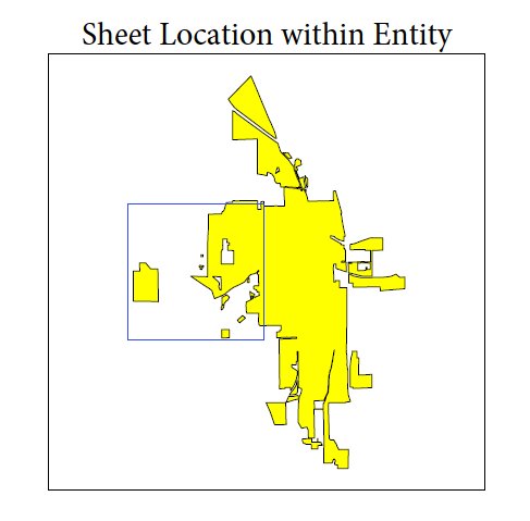
Figure A6.13: The Sheet Location within Entity key shows where the parent map sheet is located within the entity to which it belongs.
1 Legal boundary changes from the State of Georgia are the exception: a state statute requires participants to include acreage, and the Census requests that the respondent includes an authorization number.
2 Entity refers to any local governmental unit, e.g. a county, incorporated place, or minor civil division.
3Within the scope of BAS, the terms ‘map’ and ‘map sheet’ have the same meaning, and they are used interchangeably throughout this document.
| File Type | application/msword |
| Author | Bureau Of The Census |
| Last Modified By | waggo006 |
| File Modified | 2012-11-05 |
| File Created | 2012-09-11 |
© 2026 OMB.report | Privacy Policy