Assessment of USGS Science for Next-Generation Infrastructure Needs
DOI Generic Clearance for the Collection of Qualitative Feedback on Agency Service Delivery
QOS_Questions 2017-07-19
Assessment of USGS Science for Next-Generation Infrastructure Needs
OMB: 1090-0011
Qualitative Feedback on Agency Service Delivery for DOI review
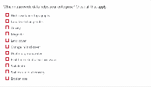
Q1: Where do you need high-resolution topography now? Check all that apply.
[ ] Alaska
[ ] West coast and Pacific islands
[ ] Southwest
[ ] Intermountain West
[ ] Plains west of Mississippi River
[ ] Southern states
[ ] North Eastern Seaboard
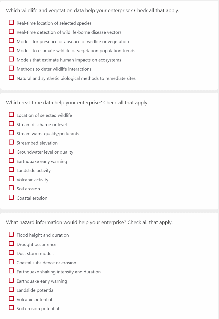
Q2: Which nationwide data helps your enterprise? Check all that apply.
[ ] High-resolution topography
[ ] Land level change rates (subsidence)
[ ] Gravity
[ ] Magnetic
[ ] Land cover
[ ] Change in land cover
[ ] Depth to groundwater
[ ] Real-time extent of surface water
[ ] Soil depth
[ ] Soil texture or chemistry
[ ] Erosion rate
Q3: Which wildlife and vegetation data help your enterprise? Check all that apply.
[ ] Real-time location of selected species
[ ] Real-time detection of wildlife-borne disease vectors
[ ] Models for presence or absence of wildlife or vegetation
[ ] Models to estimate wildlife or vegetation population trends
[ ] Models that estimate human impacts on ecosystems
[ ] Methods to deter wildlife interactions.
[ ] Natural and synthetic biological methods to remediate sites
Q4: Which real-time data help your enterprise? Check all that apply.
[ ] Location of selected wildlife
[ ] Stream discharge or level
[ ] Stream water quality/pollutants
[ ] Streambed elevation
[ ] Groundwater level or quality
[ ] Earthquake early warning
[ ] Landslide activity
[ ] Volcanic activity
[ ] Soil erosion
[ ] Coastal erosion
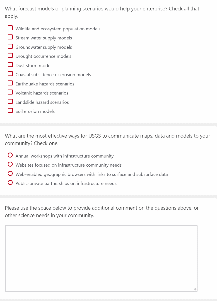
Q5: What hazard information would help your enterprise? Check all that apply.
[ ] Flood height and duration
[ ] Drought occurrence
[ ] Dust storm models
[ ] Coastal subsidence or erosion
[ ] Earthquake shaking intensity and duration
[ ] Earthquake early warning
[ ] Landslide potential
[ ] Volcanic potential
[ ] Soil erosion potential
Q6: What forecast models or planning scenarios would help your enterprise? Check all that apply.
[ ] Wildlife and ecosystem population models
[ ] Stream water supply models
[ ] Groundwater supply models
[ ] Drought occurrence models
[ ] Dust storm models
[ ] Coastal subsidence or erosion models
[ ] Earthquake hazards scenarios
[ ] Volcanic hazards scenarios
[ ] Landslide hazard scenarios
[ ] Soil erosion models
Q7: What are the most effective ways for USGS to communicate maps, data and models to your community? Check one.
[ ] Annual workshops with infrastructure community
[ ] Websites focused on infrastructure community needs
[ ] Web-enabled geographic browsers with links to surface and subsurface data
[ ] Public-private partnerships on infrastructure needs
Please use the space below to provide additional comment on the questions above, or other science needs in your community.
| File Type | application/vnd.openxmlformats-officedocument.wordprocessingml.document |
| Author | Stock, Jonathan |
| File Modified | 0000-00-00 |
| File Created | 2021-01-22 |
© 2026 OMB.report | Privacy Policy