519 NWS Survey Final 8-21-12
American Customer Satisfaction Index "Customer Satisfaction Surveys"
2012 519 NWS Survey Final 8-21-12
516 ACSI General Aviation Survey - 519 NWS Survey Final
OMB: 1090-0007
N WS
Overall
Customer Satisfaction Survey 2012
Weather Note: Section headers will not be included in online survey. Items in bold are programmer instructions. Response options will be randomized, except when sequential. All rated questions include a “don’t know” or “NA” option.
Introduction
The National Oceanic and Atmospheric Administration’s (NOAA) National Weather Service (NWS) is committed to serving the needs of all of its users. The NWS is undertaking research on how satisfied users are and would appreciate your feedback. The purpose of this research, conducted in partnership with the federal government as part of the American Customer Satisfaction Index, is to help the NWS improve its services for you and others like you.
Your answers are voluntary, but your opinions are very important for this research. Your responses will be held completely confidential, and you will never be identified by name. CFI Group, a third party research and consulting firm, is administering this survey via a secure server. The time required to complete this survey will depend on how certain questions are answered, but will likely take about 20 minutes, and is authorized by Office of Management and Budget Control No. 1505-0191.
Please click on the “Next” button below to begin the survey.
Information About You
The following questions are intended to help us better understand your responses by allowing us to classify responses by geographic area and by type of users.
From the list below, please select the continent or country in which you live or work. (drop down list of major countries)
United States
Other, please specify (Capture)
(If Q1=1) Please enter your zip code (Capture)
(If Q1=1) What sector do you represent?
Government
Commercial (most businesses)
Not-for-profit sector
Research/Academia
Private Citizen
What is your primary use of information provided by the NWS?
Agriculture (skip to Q7)
Aviation
Amateur Radio (skip to Q7)
Broadcast/Print Media (skip to Q7)
Commodities Markets (skip to Q7)
Consulting/Added Value Customer Forecast Services (skip to Q7)
Education (e.g., formal education or training of children and adults) (skip to Q7)
Emergency Response/Public Safety (skip to Q6)
Energy/Utilities (skip to Q7)
Environmental Resource Management (e.g., water resource, wildlife, estuaries, park service) (skip to Q6)
Fire Weather (skip to Q6)
Health Care Services (skip to Q7
Internet Provider (skip to Q7)
Marine (e.g., commercial transport, commercial fishing, harbor management, search and rescue) (skip to Q7)
NWS Data Provider (e.g., storm spotter, co-op observer) (skip to Q7)
Personal (skip to Q7)
Recreation (e.g., boating, flying, fishing and hunting, beachgoer, etc.) (skip to Q7)
Research (applied and basic) (skip to Q7)
Other (please specify) (skip to Q7) (Capture)
(only if Q4=2) For what type of Aviation do you use NWS information?
Dispatcher
Commercial Freight
Commercial Passenger
Private Aircraft for Business
Private Aircraft for Pleasure
What is the primary scope of your responsibility?
National
Regional (all or parts of multiple states)
Single state
All or parts of multiple counties, parishes or boroughs
Large city/urban area
Small city/township/suburban
Rural
Other (please specify) (Capture)
(Both question 7 and question 8 will be shown in a grid with two columns. Grid column headers are worded as directed by the question text below.)
By which means of communication do you obtain weather, water, and climate information? (Select all that apply)
Of the means of communication you selected, which do you find most reliable? (Please select only one)
NWS Web Sources
Non-NWS Web Sources
Mobile devices (e.g, PDA/Tablet PC, Cell Phone, Smart Phone)
Social Media (e.g., Facebook, Twitter)
Email Alerts
NOAA Dissemination Services:
NOAA Weather Radio/All Hazards
NOAA Weather Wire
Family of Services (FOS)
Emergency Managers Weather Information Network (EMWIN)
NOAAPort
File transfer services (e.g., map services, RSS feeds, FTP)
Direct interaction with NWS staff (e.g., in-person, telephone, NWSChat)
Aviation Weather Services:
World Area Forecast System (WAFS)
Direct User Access Terminal Service (DUATS)
Flight Services
Media:
Local or cable TV
Commercial Radio
Satellite radio
Satellite TV
Newspaper
Marine Broadcasts:
U.S. Coast Guard Broadcasts (HF/MF/VHF/NBDP)
NAVTEX receiver
Immarsat-C SafetyNET
Radiofacsimile
Other (please specify) (Capture)
What types of NOAA products do you most often use? (Select all that apply)
Forecasts, watches, warnings, alerts
Observational data
Model output
Outreach/educational materials
Other (Capture)
Not Applicable / Don’t Know
9a What sources will you use, or continue to use, to get NWS information in the next one to five years? (Select all that apply)
Desktop/laptop computer
Mobile Device (e.g., PDA/Tablet PC, Cell Phone/Smart Phone)
Social Media (e.g., Facebook, Twitter)
Direct Interaction with NWS Staff (e.g., in-person, telephone, NWSChat)
NOAA Weather Radio All-Hazards
File transfer services (e.g., map services, RSS feeds, FTP)
Email Alerts
Other (please specify) (Capture)
General Satisfaction with the NWS
Hazardous Services
The NWS issues outlooks, watches, warnings, and advisories of hazardous, weather-related events for the protection of life and property.Referring specifically to hazardous, weather-related information provided by the NWS, on a 10-point scale, where 1 means “Poor” and 10 means “Excellent,” please rate each of the hazardous weather warnings, outlooks, or statements on the following.
|
Ease of Understanding |
Timeliness |
Accuracy |
|
|
|
|
|
|
|
|
|
|
|
|
|
|
|
|
|
|
|
|
|
|
|
|
|
|
|
|
|
|
|
|
|
|
|
|
|
|
|
|
|
|
|
|
|
|
|
|
Do you have a hazardous weather emergency preparednesskit?
(If Yes)How long have you had one?
For more than two years
For 6 months to 2 years
For less than 6 months
Please select up to three reasons that most influenced you to create a kit.
Friends and family
General desire to be prepared
An extreme weather event
“Be a Force of Nature” campaign
“Weather-Ready Nation” campaign
Other public education campaign (please specify)(Capture)
Other (Capture)
(If No)What would you say is the biggest reason why you do not have a kit?
Takes too much time
Too expensive
Not sure what to include
Don’t think it’s necessary
Other (Capture)
Do you have a hazardous weather safety plan?
(If Yes)How long have you had a plan?
For more than two years
For 6 months to 2 years
For less than 6 months
Please select the top three reasons that influenced you to create a plan.
Friends and family
General desire to be prepared
An extreme weather event
Be a Force of Nature campaign
Weather-Ready Nation campaign
Other public education campaign (specify) (Capture)
Other (Capture)
(If No)What would you say is the biggest reason why you do not have a plan?
Takes too much time.
Too expensive.
Not sure what to include.
Don’t think it’s necessary.
Other (Capture)
Have you received a National Weather Service tornado warning for your location within the past year? (Yes/No)
How likely would you be to stop what you are doing and take some form of protective action if you learn that the National Weather Service issued a tornado warning that included your location?
Not at all likely
Somewhat likely (Skip to Q27)
Very likely (Skip to Q27)
You have indicated that it is not at all likely that you would stop what you are doing and take protective action after receiving a tornado warning. From the list below, please select the statement that best represents the reason why it is not all likely that you would stop and take protective action.
I do not believe I would be directly impacted by the tornado
I normally wait until I see the threatening weather
Previous experiences lead me to believe that my location will not be in danger
I do not trust the accuracy of tornado warnings
Other (Please state why)(Capture)
Assume you are in a tornado warning and a tornado occurs, but it does not affect your immediate location. Please select how close to your location a tornado must occur for you to consider the warning accurate.
Within 1 mile of my location
Within 5 miles of my location
Within 10 miles of my location
Within 25 miles of my location
If there was a tornado warning for your location, and a tornado did not occur, how do you think it would influence your decision making the next time a tornado warning was issued?
a. Not at all influenced (I will still heed next warning)
b. Somewhat influenced
c. Highly influenced (I will now ignore next warning)
Based on actual tornado occurrences in your vicinity, what is your opinion about the number of warnings issued for those events?
Too many tornado warnings issued
Too few tornado warnings issued
Just about the right amount of tornado warnings issued
The number of warnings issued is not a concern to me
For which of the following decisions do you use NWS fire weather products and services? (Select all that apply)
a. Determining resource requirements
b. Adjusting staffing or planning levels
c. Planning operating hours
d. Planning daily activities
e. Recreation
f. Other (please specify)
g. I don’t use NWS fire weather products and services (SKIP to Q32, Routine, Climate, Water and Weather Services)
How often do you take action based on a Fire Weather Watch or a Red Flag Warning?
a. Always
b. Usually
c. Sometimes
d. Rarely
e. Never
Routine Climate, Water and Weather Services
Which of the following routine weather, water, or climate forecast elements have you used within the past year:
Temperature (Max/Min) forecasts
Chance (Probability) of Precipitation forecasts
Cloud Cover forecasts
Wind (Direction, Speed) forecasts
Dew Point forecasts
River Heights/Flow forecasts
Ultraviolet (UV) Index forecasts
Air Quality forecasts
Wave Height forecasts
1 to 4-Week National Outlooks for Temperature and Precipitation
3-Month National Outlooks for Temperature and Precipitation
El Niño/La Niña Outlooks
3-Month Drought Outlooks
3-Month Local Temperature Outlooks
Climate Hazard Assessments
(Respondents will only rate elements selected in Q32) Referring specifically to elements found in routine weather, water, or climate forecasts provided by the NWS, on a 10-point scale, where 1 means Poor and 10 means Excellent, please rate each of the elements below on the following.
|
Ease of Understanding |
Accuracy |
|
|
|
|
|
|
|
|
|
|
|
|
|
|
|
|
|
|
|
|
|
|
|
|
|
|
|
|
|
|
|
|
|
|
|
|
|
|
|
|
|
|
|
|
|
NWS public weather forecasts are available for up to 7 days into the future. This means that a 1-day forecast is for the weather 1 day (24 hours) from now, that a 3-day forecast is for the weather 3 days (72 hours) from now, and so on. Using a scale from 1 to 10 where 1 means Not at all Confident and 10 is Very Confident, how confident are you in max/min temperature forecasts for the times listed below?
1 day from now
3 days from now
7 days from now
Forecasts issued by the NWS routinely include a probability of precipitation (PoP) statement, which is often expressed as the "chance of rain" or "chance of precipitation." The PoP, expressed in percent, describes the chance of measurable precipitation (at least 0.01 inch) occurring during a specified 12-hour period.
Using a scale from 1 to 10 where 1 is Not at all Confident and 10 is Very Confident, how confident are you in probability of precipitation forecasts for the times listed below?
1 day from now
3 days from now
7 days from now
Using a scale from 1 to 10 where 1 is Not at all Confident and 10 is Very Confident. How confident are you in amount of precipitation inforecasts for the times listed below?
Less than 1 day from now
1 day from now
3 days from now
Weather-Ready Nation and Decision Support Services
Have you heard of the term “Weather-Ready Nation”? (Yes/No) (If No, skip to Q59)
Where did you hear about Weather-Ready Nation?
National Weather Service employee
On social media
In the news
At an event
Other (Capture)
Have you heard of the “Be a Force of Nature” campaign? (Yes/No) (If No, skip to Q61)
Where did you hear about “Be a Force of Nature”?
National Weather Service employee
On social media
In the news
At an event
Other (Capture)
Do you identify yourself as someone whose job it is to make decisions based on weather-related information? (If the answer is “NO” skip to Dissemination Services. If the answer is “YES” continue.)
Has NWS staff ever served on-site at an incident providing decision support to your organization?
Yes (Please list the incident type) (Capture)
No
Please rate your interaction with the NWS for decision support on each of the following using a 10 point scale, where 1 means Poor and 10 means Excellent:
Accessibility. If the score is less than 7, please explain. (Capture)
Responsiveness. If the score is less than 7, please explain. (Capture)
Knowledge. If the score is less than 7, please explain. (Capture)
Professionalism. If the score is less than 7, please explain. (Capture)
Assisting in the interpretation of weather-related information to help you make a decision. If the score is less than 7, please explain. (Capture)
Resolving a complaint. If the score is less than 7, please explain. (Capture)
Please list any weather-related threshold(s) which, if met or exceeded, would trigger an action on your part (e.g., rainfall exceeds 3" in 6-hours, temperatures fall below freezing, winds above 60 mph). (Capture)
Dissemination Services
The NWS strives to use the latest technologies and services available to disseminate climate, water, and weather information in gridded, graphical, image, and text form to meet the needs of its users.
Using a 1 to 10 scale, where 1 means Poor and 10 means Excellent, please the rate reliability of satellite data available through the NWS web sites. (11=don’t use)
Using a 1 to 10 scale, where 1 means Poor and 10 means Excellent, please rate the reliability of radar data available through the NWS web sites. (11=don’t use)
(only if Q70 and Q71<>11) Please provide any suggestions on how the NWS can further improve its satellite or radar data. (Capture)
Weather.gov design refresh is the beginning of a phased effort to update the NWS Web presence and improve customer access to information and services. The goal of this first phase is to improve content organization, navigation, look and feel, functionality, and usability of Weather.gov.
Referring specifically to the Weather.gov design refresh, on a 10-point scale, where 1 means Poor and 10 means Excellent, please rate the following three questions:
Ease of accessing/finding information
Ease of understanding information
Information is up-to-date
Is an NWS Web page (e.g., local, regional, national) your primary source of weather information?
If “yes,” please state why. (Capture)
If “no,” please state why not. (Capture)
If you could make an improvement to any NWS Web page(e.g., local, regional, national), what would it be? Please include the URL in your response. (Capture)
Do you identify yourself as one who generally requires specific products for commercial or research purposes and has automated methods (e.g., NOMADS, FTPPRD, NOAAport, RSS feeds, Family of Services, EMWIN) for ingesting data?
Yes
No (skip to Outreach and Weather Education section, Q85)
Using a 1 to 10 scale where 1 means Poor and 10 means Excellent, please rate…
The ease of locating data on NWS dissemination servers
The ease of requesting that additional data be added to NWS dissemination streams or servers
The ease of providing input into the decision making process for the development of new NWS products.
The ease of using NOAA automated methods of dissemination (e.g., NOMADS, FTPPRD, NOAAPort, RSS Feeds, Family of Services, EMWIN)
Please provide any suggestions on how the NWS can further improve its automated dissemination methods. (Capture)
Describe data formats or standards not available today that you would like the NWS to offer in the future. (Capture)
Outreach and Weather Education
Are you aware of the NWS“Turn Around Don’t Drown®” campaign to warn people of the hazards of walking or driving a vehicle through flood waters? (Yes/No) (If No, skip to question 87)
Using a scale from 1 to 10 where 1 means Not at all Effective and 10 is Very Effective, in your personal experience, how effective have you found these campaigns?
Are you aware of the NWS“When Thunder Roars, Go Indoors!” Campaign to warn people of the dangers of lightning? (Yes/No) (If No, skip to Customer Satisfaction Index section, question 89)
Using a scale from 1 to 10 where 1 means Not at all Effective and 10 is Very Effective, in your personal experience, how effective have you found this campaign
Customer Satisfaction Index
Now, please think about your overall satisfaction with the NWS.
First, please consider all of your experiences with the NWS. Using a 10-point scale on which 1 means Very Dissatisfied and 10 means Very Satisfied, how satisfied are you with the NWS?
Using a 10-point scale on which 1 now means Falls Short of your Expectations and 10 means Exceeds your Expectations, to what extent has the NWS fallen short of, or exceeded your expectations?
Now, imagine what an ideal organization providing weather information would be like. How well do you think the NWS compares with that ideal organization you just imagined? Please use a 10-point scale on which 1 means Not Very Close to the Ideal, and 10 means Very Close to the Ideal.
Desired Outcomes
Using a 10-point scale where 1 means Not at all Likely and 10 means Very Likely, how likely would you be to take action based on the information you receive from the NWS?
Using a 10-point scale, on which 1 means Not at all Likely and 10 means Very Likely, how likely are you to use the NWS as a source of weather information in the future?
Using a 10-point scale on which 1 means Not at all likely and 10 means Very likely, how likely are you to recommend the NWS to a colleague or friend?
How can the NWS improve its products and services, today or in the future, to better meet your needs? (Capture)
Demographics (not required)
What is your age? (Capture)
What is your gender?
Male
Female
What is your race or origin?
White, Caucasian
Black, African American
Hispanic, Latino, or Spanish
Pacific Islander
Asian
American Indian/Native Indian or Alaska Native
Other (Capture)
What is the highest degree or level of school you have completed?
12th grade or less (no diploma)
High school diploma or GED
Some college, no degree
Associate or technical degree
Bachelor’s degree
Graduate degree/Professional degree
[SEND SURVEY RESPONDENTS TO THE FOLLOWING WEB PAGE WHEN SURVEY HAS BEEN COMPLETED:[http://www.nws.noaa.gov/com/weatherreadynation/]
Optional Sections
1) National Hazardous Weather Services
The NOAA/NWS Storm Prediction Center (SPC) issues outlooks and watches for hazardous, weather-related events for the protection of life and property. The responses to the next 11 questions will be used by the SPC to help shape future product improvements.
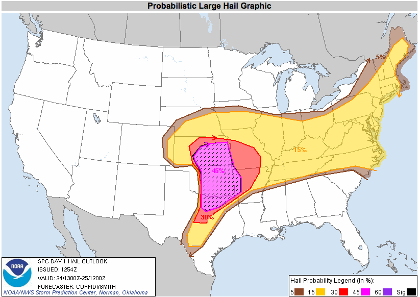
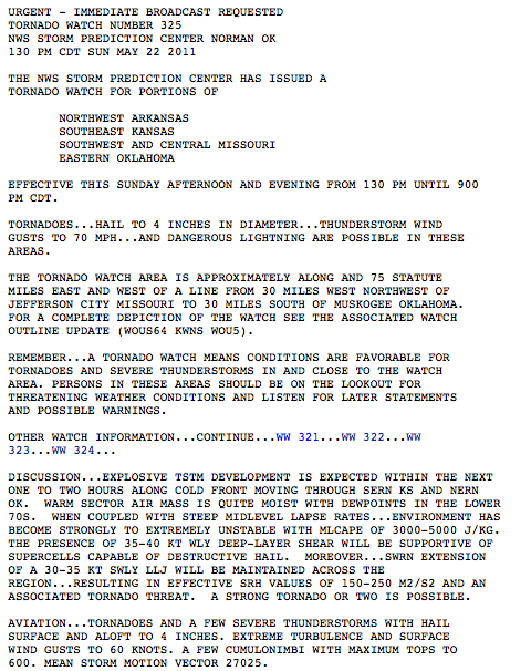
Sample SPC products are provided next before the corresponding questions.


Convective Outlook Discussion Example
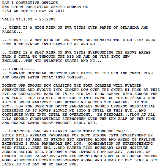
Mesoscale Convective Discussion

Mesoscale Discussion Example


Watch Discussion Example
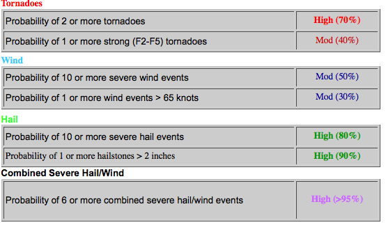
Watch Probabilities
Watch Status Message sample
WOUS20 KWNS 252240
WWASPC
SPC WW-A 252240
NYZ000-OHZ000-PAZ000-LEZ000-LOZ000-092300-
STATUS REPORT ON WW 737
THE SEVERE WEATHER THREAT CONTINUES TO THE RIGHT OF A LINE FROM 50 SW HUM TO 30 NW BE.
..KERR..11/25/07
ATTN...WFO...LCH...LIX...
&&
SEVERE WEATHER THREAT CONTINUES FOR THE FOLLOWING AREAS
LAC075-252300-
LA
. LOUISIANA PARISHES INCLUDED ARE
PLAQUEMINES
GMZ550-252300
CW
. ADJACENT COASTAL WATERS INCLUDED ARE
COASTAL WATERS FROM THE SOUTHWEST PASS OF THE MISSISIPPI RIVER
TO LOWER ATCHAFALAYA RIVER LA OUT 20 NM
$$
THE WATCH STATUS MESSAGE IS FOR GUIDANCE PURPOSES ONLY. PLEASE REFER
TO WATCH COUNTY NOTIFICATION STATEMENTS FOR OFFICIAL INFORMATION ON
COUNTIES... INDEPENDENT CITIES AND MARINE ZONES CLEARED FROM SEVERE
THUNDERSTORM AND TORNADO WATCHES.
$$
Public Weather Outlook Example
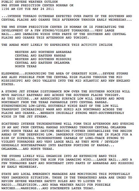
Enhanced
Thunderstorm Outlook Example (for 20z-00z)
1. Please rank the following SPC products in order of those which you use most often from day to day, where “1” is most used. If you do not use the product, please select “Not Used.”
SPC Product |
Rank |
Not Used |
Convective Outlooks |
|
|
Mesoscale Discussions |
|
|
Severe Thunderstorm/Tornado Watches |
|
|
Watch Status Messages |
|
|
Enhanced Thunderstorm Outlooks |
|
|
Public Weather Outlooks |
|
|
Storm Reports Webpage |
|
|
2. Please rank the following SPC products in order of those you use most on severe weather days, where “1” is most used. If you do not use the product, please select “Not Used”.
SPC Product |
Rank |
Not Used |
Convective Outlooks |
|
|
Mesoscale Discussions |
|
|
Severe Thunderstorm/Tornado Watches |
|
|
Watch Status Messages |
|
|
Enhanced Thunderstorm Outlooks |
|
|
Public Weather Outlooks |
|
|
Storm Reports Webpage |
|
|
3. Please rank the following information in SPC Convective Outlooks in order of usefulness (i.e., most often used, most important to your operations), where “1” is most useful. If you do not use the product, please select “Not Used
SPC Convective Outlook Information |
Rank |
Not Used |
Categorical risk info (Slight, Moderate or High risk) |
|
|
Probabilistic information (wind, hail, tornado) |
|
|
Text discussion |
|
|
4. Please rank the following information in SPC Mesoscale Convective Discussions in order of usefulness (i.e., most often used, most important to your operations), where “1” is most useful. If you do not use the product, please select “Not Used.
SPC Mesoscale Convective Discussion Information |
Rank |
Not Used |
Watch issuance probability information (likely [80-95%], unlikely [5-20%], possible [40-60%]) |
|
|
Graphical information |
|
|
Summary discussion |
|
|
Technical discussion |
|
|
5. Please rank the following information in SPC Watch Products in order of usefulness (i.e., most often used, most important to your operations), where “1” is most useful. If you do not use the product, please select “Not Used.
SPC Watch Product Information |
Rank |
Not Used |
Graphic (watch box outline) |
|
|
Text discussion |
|
|
Watch probabilities (for tornadoes, hail, wind) |
|
|
6. Where do you receive SPC information? Check all that apply.
Local TV or Radio
State or local government messaging system
Free commercial service (The Weather Channel, Wunderground.com, etc)
Contract commercial service (Accuweather or other paid subscription service)
NOAA All-Hazards Weather Radio
SPC Website (www.spc.noaa.gov)
Local NWS Forecasts (NWS/WFO website, telephone coordination calls)
Digital media (Facebook/Twitter, text, email)
Other (please explain)
7. Which, if any, of the following SPC products do you disseminate via digital media (email, text messages, social media, etc.)? Check all that apply.
Convective Outlooks
Severe Thunderstorm/Tornado Watches
Mesoscale Convective Discussions
Public Weather Outlooks
None
8. Through which digital media channels do you disseminate these products? Check all that apply.
Facebook
Twitter
Text messages
Email
Personal website
9. Who is your target audience when disseminating these products? Check all that apply.
Friends and family
Emergency officials (police, fire, first responders)
Emergency management personnel (Federal, state or county level)
State and local government
Education officials
Broadcast/print news media
Aviation interests
Recreational users (boaters, hunters, campers, etc)
Hospitals/Medical facilities
Commercial businesses
Public transportation officials (bus, train service providers)
Other (please explain)
10. Do you have specific suggestions for improvements you would like to see on the SPC Website or to other products and services?
11. Do you have any additional comments related to the previous ten questions?
2) National Marine Weather Services
Beach Hazard Questions
Have you heard about our new NWS Beach Hazard Statement? (Y/N) If no are you interested in learning about it? (Yes No)
Please rank in order of importance what you consider to be the five most important beach hazards you would like to know about before going to the beach.
Rip currents (channelized currents of water flowing away from shore at surf beaches);
Other dangerous coastal currents;
Sneaker waves (extremely large coastal waves that can appear without warning);
Lightning/severe thunderstorms;
Rough surf (big waves of the sea breaking on the shore);
Red tide (harmful algal blooms which can be toxic);
Frigid water temperatures (cold water emersion/hypothermia);
Heat;
Ultra violet light (UV).
Other (please specify)
3) Before you go to the beach, do you gather information about weather or marine environmental hazards you might encounter while at the beach? (Y/N) If yes, what is your primary source of this information? Please specify. (Reference question 2 for a list of beach hazards).
4) If a Beach Hazard Statement indicated the potential for a hazard, such as those listed in question 2, how much would the statement influence your decision on whether or not to go to the beach? (A lot, some, very little, not at all).
Using a 10 point scale where 1 means, ‘not at all valuable’ and 10 means ‘very valuable’, how valuable would a beach hazard statement be to you, if the statement contains information on potentially harmful hazards at the beach you want to visit, or spend your vacation, or conduct a professional event? If your answer is ‘not valuable’, please explain why you wouldn’t find it valuable to you.
Storm Surge Questions, Created 3/14/12
Marine and coastal weather products and services are designed for the U.S. Coast (extending from the immediate coastline outward to 60 nautical miles from shore), or Offshore (extending outward to 250 nautical miles), or High Seas (far offshore sections of the open Atlantic, Pacific, Gulf of Mexico, and/or Caribbean Sea) areas.
This survey asks about your experience with NWS products and services in the storm surge and Beach Hazards.
Storm Surge [positive (onshore)/negative (offshore)]: Storm surge is the onshore/offshore rush of sea or lake water caused by the high winds associated with a land falling tropical or extra-tropical cyclone.
1) What has been your experience with storm surges? (select one)
I have never have been impacted by one
It has damaged my property
I or someone I know had to be rescued from one
It has caused severe flooding in my area
Don’t know
Other, please explain (capture)
2) Please indicate your level of familiarity with each of the following storm surge products on a scale of 1 to 10 where 1 means “not at all familiar” and 10 means “very familiar.”
Coastal Flood Watch
Coastal Flood Advisory
Coastal Flood Warning
Storm Surge information in Hurricane Local Statements
Storm Surge information in Hazardous Weather Outlooks
Storm Surge information in Tropical Cyclone Public Advisories
3) Of the NWS Storm Surge information you have received for tropical and extra-tropical systems, using a 1 to 10 scale where 1 means ‘Poor’ and 10 means ‘Excellent’, how would you rate the:
Ease of understanding the storm surge products
Usefulness of the storm surge products
Improvements in storm surge forecasting over the past five years
Overall quality of storm surge products and services
4) Using a 1 – 10 scale, where 1 means ‘Not at All Useful’ and 10 means ‘Very Useful’, how useful would probabilistic storm surge information (e.g., the probability of a specific water level at a specific location, probability of exceeding a specific surge height) be to you?
5) Should the NWS begin issuing storm surge watches and warnings?
Yes
No
6) (If Q95=1) Do you think a new watch/warning for extreme coastal inundation should apply to both tropical and severe extra tropical storm surge events? (an example of an extreme extra-tropical event was the Florida Gulf coast and Atlantic coast inundation from the March 1993 Superstorm.)
Yes
No
7) If the NWS began issuing storm surge watches and/or warnings, what format would be most useful to you?
Text
Graphical
Digital
Other (Capture)
8) If the NWS adopts a storm surge warning, what geographical area should be included in a storm surge warning?
NWS Zone
County
Storm-based polygon (as now used for severe thunderstorms, flash floods, and tornadoes)
Other (Capture)
9) At what point does negative storm surge (offshore rush of water and sometimes referred to as a “blowout tide”) affect how you conduct operations? Please select one of the ranges listed below.
-1 to -2 ft
-2 to -3 ft
-3 to -5 ft
> -5 ft
Negative storm surge does not affect how I conduct operations.
Not applicable
Other (Capture)
10) Do you have any recommendations for improvement to the NWS storm surge program? (Capture)
11) Please select the time period below that would provide you with adequate amount of time to take action before a possible extreme coastal inundation event
<12 hours
12-24 hours
24-36 hours
36-48 hours
2-3 days
> 3 days
3) National Aviation Weather Services
Aviation Weather Services are provided by the Aviation Weather Center, Center Weather Service Units, and Weather Forecast Offices. Samples of aviation forecast products are provided next before corresponding questions.
FAUS44
KKCI 280945 FA4W
DFWC
FA 280945 SYNOPSIS
AND VFR CLDS/WX SYNOPSIS
VALID UNTIL 290400 CLDS/WX
VALID UNTIL 282200...OTLK VALID 282200-290400 OK
TX AR TN LA MS AL . SEE
AIRMET SIERRA FOR IFR CONDS AND MTN OBSCN. TS
IMPLY SEV OR GTR TURB SEV ICE LLWS AND IFR CONDS. NON
MSL HGTS DENOTED BY AGL OR CIG. . SYNOPSIS...10Z
DRYLINE SW KS-ERN TX PNHDL-ECNTRL NM-50W INK-MRF. HI
PRES RDG ERN TX-SE AL-SC CSTL WTRS. 18Z DRYLINE 40S
HLC-LBB-INK-90SSE MRF. CDFNT WCNTRL KS-NW PTNS TX PNHDL-NR ELP.
HI PRES GA CSTL WTRS-SW MS-CNTRL TX. 04Z DRYLINE SW KS-CNTRL PTNS
OK PNHDL-TXO-30W INK-MRF. HI PRES RDG SE TX-SRN MS-NERN FL PEN. . OK PNHDL...SKC.
TIL 13Z OCNL VIS 3-5SM BR. OTLK...VFR. WRN...BKN030-040
TOP 060. VIS 3-5SM BR. 15Z BKN060 TOP 080. OTLK...VFR. CNTRL...SKC.
12Z OVC025 TOP 040. VIS 3-5SM BR. 15Z BKN045 TOP 060.
OTLK...VFR. ERN...SKC.OCNL
VIS 3-5SM BR. 15Z BKN050 TOP 080. 19Z SCT060 BKN100
TOP 140. OTLK...VFR. .

Significant Weather Chart
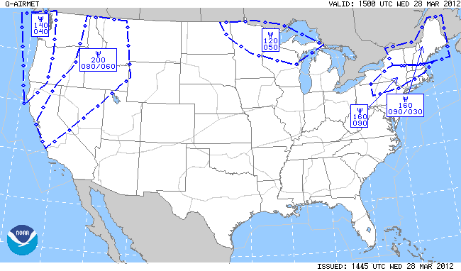


What type of aviation do you use NWS information for?
-General Aviation
-Dispatcher
-Commercial Freight
-Commercial Passenger
-Private Aircraft for Business
-Private
Aircraft for Pleasure
-Other
How often do you use the following products: (Choices: “1-2 times per year”, “3-6 times per year”, “At least once per month”, “2-4 times per month”, “More than 4 times per month”)
|
1-2 times per year |
3-6 times per year |
At least once per month |
2-4 times per month |
More than 4 times per month |
Terminal Aerodrome Forecasts (TAFs)
|
|
|
|
|
|
Area Forecasts (FAs)
|
|
|
|
|
|
Surface Observations (METARs/SPECIs)
|
|
|
|
|
|
Convective Collaborative Forecast Product (CCFP)
|
|
|
|
|
|
Significant Metrological Information (SIGMET)
|
|
|
|
|
|
Airmen’s Meteorological Information (AIRMET)
|
|
|
|
|
|
Current Icing Product (CIP)/ Forecast Icing Product (FIP) Graphical Turbulence Guidance (GTG)
|
|
|
|
|
|
Center Weather Advisories (CWAs) |
|
|
|
|
|
Meteorological Impact Statements (MISs)
|
|
|
|
|
|
Airport Weather Warning (AWW)
|
|
|
|
|
|
Significant Weather Charts (SIGWX) |
|
|
|
|
|
Volcanic Ash Advisories
|
|
|
|
|
|
LAMP
|
|
|
|
|
|
Wind/Temp aloft
|
|
|
|
|
|
TRACON forecast
|
|
|
|
|
|
Aviation Discussion
|
|
|
|
|
|
3) How useful are the products listed below (1=not at all useful, 10=very useful)
|
1 |
2 |
3 |
4 |
5 |
6 |
7 |
8 |
9 |
10 |
Terminal Aerodrome Forecasts (TAFs)
|
|
|
|
|
|
|
|
|
|
|
Area Forecasts (FAs)
|
|
|
|
|
|
|
|
|
|
|
Surface Observations (METARs/SPECIs)
|
|
|
|
|
|
|
|
|
|
|
Convective Collaborative Forecast Product (CCFP)
|
|
|
|
|
|
|
|
|
|
|
Significant Metrological Information (SIGMET)
|
|
|
|
|
|
|
|
|
|
|
Airmen’s Meteorological Information (AIRMET)
|
|
|
|
|
|
|
|
|
|
|
Current Icing Product (CIP)/ Forecast Icing Product (FIP) Graphical Turbulence Guidance (GTG)
|
|
|
|
|
|
|
|
|
|
|
Center Weather Advisories (CWAs) |
|
|
|
|
|
|
|
|
|
|
Meteorological Impact Statements (MISs)
|
|
|
|
|
|
|
|
|
|
|
Airport Weather Warning (AWW)
|
|
|
|
|
|
|
|
|
|
|
Significant Weather Charts (SIGWX) |
|
|
|
|
|
|
|
|
|
|
Volcanic Ash Advisories
|
|
|
|
|
|
|
|
|
|
|
LAMP
|
|
|
|
|
|
|
|
|
|
|
Wind/Temp aloft
|
|
|
|
|
|
|
|
|
|
|
TRACON forecast
|
|
|
|
|
|
|
|
|
|
|
Aviation Discussion
|
|
|
|
|
|
|
|
|
|
|
-
(Only if Q3=1 (not very useful)) Select the best reason why you feel these products are not very useful:
I have no confidence in the product.
The product is NOT relevant for my purposes.
The product is too confusing.
There needs to be more training for this product.
The product is antiquated and is NOT needed anymore.
Terminal Aerodrome Forecasts (TAFs)
Area Forecasts (FAs)
Surface Observations (METARs/SPECIs)
Convective Collaborative Forecast Product (CCFP)
Significant Meteorological Information (SIGMET)
Airmen’s Meteorological Information (AIRMET)
Current Icing Product (CIP)/Forecast Icing Product (FIP)
Graphical Turbulence Guidance (GTG)
Center Weather Advisories (CWAs)
Meteorological Impact Statements (MISs)
Airport Weather Warning (AWW)
Significant Weather Charts (SIGWX)
Volcanic Ash Advisories
LAMP
Winds/Temps Aloft
TRACON Forecasts
Aviation Discussion
4) On a scale of 1-10 where 1 is not confident and 10 is very confident. How confident are you in the Terminal Aerodrome Forecast (TAFs) product?
5a) On a scale of 1-10 where 1 is unaware of any training and 10 is very aware with training?
5b) On a scale of 1-10 where 1 is Very Dissatisfied with any training and 10 is Very satisfied with training?
5c) Please list the aviation training that you use? (Open comment)
6) How do you receive your information? (check all that apply)
-ADDS/Aviation Weather Center website
-Commercial vendor (XM, Jeppesen, etc.)
-FAA’s DUAT/DUATS
-FAA’s AFSS/FSS
-Television
-WAFS Internet File Service (WIFS)
-None of the above
![]()
| File Type | application/vnd.openxmlformats-officedocument.wordprocessingml.document |
| Author | Doug |
| File Modified | 0000-00-00 |
| File Created | 2021-02-03 |
© 2026 OMB.report | Privacy Policy
