436 NWS Overall Me 436 NWS Overall Measure 042211_FINAL
American Customer Satisfaction Index "Customer Satisfaction Surveys"
2011 436_ NWS Overall Measure 042211_FINAL
434 FEMA_Q's_Public_4_21_11; 435 FEMA_Q's_Local_Officials_4_21_11; 436 NWS Overall Measure 042211_FINAL; 437HRSA BCRS NHSC 2011 Partic Q's_FINAL; 438 HRSA BCRS NHSC 2011 Partner Q's_FINAL
OMB: 1090-0007
NWS Overall
Customer Satisfaction Survey 2011
![]()
Weather Note: Section headers will not be included in online survey. Items in bold are programmer instructions. Response options will be randomized, except when sequential. All rated questions include a “don’t know” or “NA” option.
Introduction
The National Oceanic and Atmospheric Administration’s (NOAA) National Weather Service (NWS) is committed to serving the needs of all of its users. The NWS is undertaking research on how satisfied users are and would appreciate your feedback. The purpose of this research, conducted in partnership with the federal government as part of the American Customer Satisfaction Index, is to help the NWS improve its services for you and others like you.
Your answers are voluntary, but your opinions are very important for this research. Your responses will be held completely confidential, and you will never be identified by name. CFI Group, a third party research and consulting firm, is administering this survey via a secure server. The time required to complete this survey will depend on how certain questions are answered, but will likely take about 20 minutes, and is authorized by Office of Management and Budget Control No. 1090505-0007.
Please click on the “Next” button below to begin the survey.
Information About You
The following questions are intended to help us better understand your responses by allowing us to classify responses by geographic area and by type of users.
From the list below, please select the continent or country in which you live or work. (drop down list of major countries)
United States
Other, please specify (capture)
(If Q1=1) Please enter your zip code (capture open-end)
(If Q1=1) What sector do you represent?
Government
Private
What is your primary use of information provided by the NWS?
Agriculture (skip to Q7)
Aviation
Amateur Radio (skip to Q7)
Broadcast/Print Media (skip to Q7)
Commodities Markets (skip to Q7)
Consulting/Added Value Customer Forecast Services (skip to Q7)
Education (e.g., formal education or training of children and adults) (skip to Q7)
Emergency Response/Public Safety (skip to Q6)
Energy/Utilities (skip to Q7)
Environmental Resource Management (e.g., water resource, wildlife, estuaries, park service) (skip to Q6)
Fire Weather (skip to Q6)
Health Care Services (skip to Q7
Internet Provider (skip to Q7)
Marine (e.g., commercial transport, commercial fishing, harbor management, search and rescue) (skip to Q7)
NWS Data Provider (e.g., storm spotter, co-op observer) (skip to Q7)
Personal (skip to Q7)
Recreation (e.g., boating, flying, fishing and hunting, beachgoer, etc.) (skip to Q7)
Research (applied and basic) (skip to Q7)
Other (please specify) (skip to Q7) (Capture)
(only if Q4=2) For what type of Aviation do you use NWS information?
Dispatcher
Commercial Freight
Commercial Passenger
Private Aircraft for Business
Private Aircraft for Pleasure
What is the primary scope of your responsibility?
National
Regional (all or parts of multiple states)
Single state
All or parts of multiple counties, parishes or boroughs
Large city/urban area
Small city/township/suburban
Rural
Other (please specify) (Capture)
By which means of communication do you obtain weather, water, and climate information? (Select all that apply)
NWS Web Sources
Non-NWS Web Sources
Mobile devices (e.g, PDA, Phone, Smart Phone)
Social Media (e.g., Facebook, Twitter)
NOAA Dissemination Services:
NOAA Weather Radio/All Hazards
NOAA Weather Wire
Family of Services (FOS)
Emergency Managers Weather Information Network (EMWIN)
NOAAPort
Aviation Weather Services:
World Area Forecast System (WAFS)
Direct User Access Terminal Service (DUATS)
Flight Services
Media:
Local or cable TV
Commercial Radio
Satellite radio
Satellite TV
Newspaper
Marine Broadcasts:
U.S. Coast Guard Broadcasts (HF/MF/VHF/NBDP)
NAVTEX receiver
Immarsat-C SafetyNET
Radiofacsimile
Other (please specify) (Capture)
As technology evolves, what sources will you most likely use to get NWS information in the next one to five years? (Select all that apply)
Desktop/laptop computer
Mobile Device (e.g, PDA, Phone, Smart Phone)
Social Media (e.g., Facebook, Twitter)
Direct Interaction with NWS Staff (e.g., in-person, telephone, NWSChat)
NOAA Weather Radio All-Hazards
File transfer services (e.g., map services, RSS feeds, FTP)
Other (please specify) (Capture open-ended)
General Satisfaction with the NWS
Hazardous Services
The NWS issues outlooks, watches, warnings, and advisories of hazardous, weather-related events for the protection of life and property.
Referring specifically to hazardous, weather-related warnings provided by the NWS, on a 10-point scale, where 1 means “Poor” and 10 means “Excellent,” please rate each of the hazardous weather warnings on the following.
|
Ease of Understanding |
Timeliness |
Accuracy |
|
|
|
|
|
|
|
|
|
|
|
|
|
|
|
|
|
|
|
|
|
|
|
|
|
|
|
|
|
|
|
|
|
|
|
|
|
|
|
|
Some of the most important products the NWS issues are Watches, Warnings, and Advisories. In previous surveys, the NWS has noted some confusion regarding the definitions of these products. Here are generalized definitions for Watch, Warning and Advisory:
Watch:
A
Watch is issued when the risk of hazardous weather has increased, but
its occurrence, location, and/or timing is still uncertain.
Warning:
A Warning is issued when hazardous weather is imminent,
occurring or has a high probability of occurrence.
Advisory:
An Advisory is issued for conditions that are less serious than
a warning, may cause significant inconvenience, but could also
threaten life and/or property if caution is not exercised.
We are investigating ways to make the clarity and understandability of NWS’s hazard products to enhance users’ reactions to these important messages. We have developed two alternative proposals to the current “Watch, Warning and Advisory” paradigm for consideration. Please indicate if you prefer to retain the current paradigm (Option A), or believe Options B or C would present our hazard information more clearly.
1. Below are possible options NWS could use to express expected weather hazards. Winter weather is used as an example:
Option A (No change) - Retain Watch, Warning and Advisory terms as they are presently. Enhance education efforts to increase understanding of these terms.
“The NWS has issued a Winter Weather Advisory for an expected light to moderate snowfall starting late this afternoon”. Slippery road conditions and snow accumulations of 1-3 inches are expected.”
Option B - Retain the Watch and Warning terms, but remove the term Advisory entirely.
Option C - Retain the Warning term to highlight the most significant impacts from weather conditions, but remove the Watch and Advisory terms entirely. Use a new phrase, such as “Winter Weather Statement” to describe both Watch and Advisory level information. An example of how such a “Statement” would be worded is provided below:
“The NWS has issued a Winter Weather Statement for the possibility of snow on Thursday. There is uncertainty with accumulation, but total snow amounts may exceed 6 inches.”
Which of the three options do you prefer (A, B, C)?
------------------------------------------------------------------------------------------------------------
2. What, if any, additional hazard information would be beneficial to you/useful to you in your decision-making? (Capture Open Ended).
3. Please provide any comments on how the NWS can improve the clarity and usefulness of its existing hazard products. (Capture Open Ended).
Routine Climate, Water and Weather Services
Which of the following routine weather, water or climate forecast elements have you used within the past year:
Temperature (Max/Min) forecasts
Chance (Probability) of Precipitation forecasts
Cloud Cover forecasts
Wind (Direction, Speed) forecasts
Dew Point forecasts
River Heights/Flow forecasts
Ultraviolet (UV) Index forecasts
Air Quality forecasts
Wave Height forecasts
1 to 4-Week National Outlooks for Temperature and Precipitation
3-Month National Outlooks for Temperature and Precipitation
El Niño/La Niña Outlooks
3-Month Drought Outlooks
3-Month Local Temperature Outlooks
Climate Hazard Assessments
(Respondents will only rate elements selected in Q19) Referring specifically to elements found in routine weather, water, or climate forecasts provided by the NWS, on a 10-point scale, where 1 means Poor and 10 means Excellent, please rate each of the elements below on the following.
|
Meets my needs |
Ease of Understanding |
|
|
|
|
|
|
|
|
|
|
|
|
|
|
|
|
|
|
|
|
|
|
|
|
|
|
|
|
|
|
|
|
|
|
|
|
|
|
|
|
|
|
|
|
|
NWS public weather forecasts are available for up to 7 days into the future. This means that a 1-day forecast is for the weather 1 day (24 hours) from now, that a 3-day forecast is for the weather 3 days (72 hours) from now, and so on. Using a scale from 1 to 10 where 1 means Not at all Confident and 10 is Very Confident, how confident are you in max/min temperature forecasts for the times listed below?
1 day from now
3 days from now
7 days from now
Forecasts issued by the NWS routinely include a probability of precipitation (PoP) statement, which is often expressed as the "chance of rain" or "chance of precipitation". The PoP, expressed in percent, describes the chance of measurable precipitation (at least 0.01 inch) occurring during a specified 12-hour period.
Using a scale from 1 to 10 where 1 is Not at all Confident and 10 is Very Confident, how confident are you in probability of precipitation forecasts for the times listed below?
1 day from now
3 days from now
7 days from now
Using a scale from 1 to 10 where 1 is Not at all Confident and 10 is Very Confident. How confident are you in amount of precipitation in forecasts for the times listed below?
Less than 1 day from now
1 day from now
3 days from now
User Support Services
Do you identify yourself as someone whose job it is to make decisions based on weather-related information? (If the answer is “NO” go to Customer Service. If the answer is “YES” proceed with the paragraph below.)
A goal of the NWS is to create a weather-ready Nation through the provision of superior Impact-based Decision Support Services (IDSS). These services will be realized through the NWS’s unique relationship with Emergency Management.
During the last six months, how many times did you interact with NWS staff to interpret weather information related to a decision you had to make for your work?
0 times (skip to Customer Support Services)
1-5 times
5-10 times
More than 10 times
During a typical interaction, approximately how much time did you spend discussing forecast, warning, and/or other information with NWS staff?
Less than 5 minutes
5 to 15 minutes
16 to 30 minutes
More than 30 minutes
Has NWS staff ever served on-site at an incident providing decision support to your organization?
Yes and please list the incident type.
No
Please rate your interaction with the NWS for decision support (IDSS) on each of the following using a 10 point scale, where 1 means Poor and 10 means Excellent:
Accessibility. If the score is less than 7, please explain.
Responsiveness. If the score is less than 7, please explain.
Knowledge. If the score is less than 7, please explain
Professionalism. If the score is less than 7, please explain.
Assisting in the interpretation of weather-related information to help you make a decision. If the score is less than 7, please explain.
Resolving a complaint. If the score is less than 7, please explain.
Please list any weather-related threshold(s) which, if met or exceeded, would trigger an action on your part (e.g., rainfall exceeds 3" in 6-hours, temperatures fall below freezing, winds above 60 mph).
Skip to last question in this section dealing with forecaster uncertainty.
Customer Support Services
During the last six months, approximately how many times did you contact NWS staff to discuss forecast, warning, and/or other information?
0 times (skip to Dissemination Services)
1-10 times
11-25 times
More than 25 times
Considering your interaction with a NWS office, please rate the NWS staff on each of the following using a 10 point scale on which 1 means Poor and 10 means Excellent:
Accessibility. If the score is less than 7, please explain.
Responsiveness. If the score is less than 7, please explain.
Knowledge. If the score is less than 7, please explain
Professionalism. If the score is less than 7, please explain.
Resolving a complaint. If the score is less than 7, please explain.
There are several reasons you may have directly contacted an NWS forecaster in the past six months about forecast, warning, or other information. Using a 1 to 10 scale where 1 means “Not at all Valuable” and 10 means “Very Valuable,” please rate the value of each of the following possible services provided by an NWS forecaster. Value is defined here as economically beneficial or an improvement to quality of life.
Clarification of weather-related information
Forecaster uncertainty (Forecaster level of confidence in his/her own forecast)
Dissemination Services
The NWS strives to use the latest technologies available to disseminate climate, water, and weather information in gridded, graphical, image, and text form to meet the needs of its users.
Using a 1 to 10 scale, where 1 means Poor and 10 means Excellent, please rate the reliability of satellite data available through the NWS web sites. (11=don’t use)
Using a 1 to 10 scale, where 1 means Poor and 10 means Excellent, please rate the reliability of radar data available through the NWS web sites. (11=don’t use)
(only if Q63 and 64<>11) Please provide any suggestions on how the NWS can further improve its satellite or radar data. (capture open-ended)
Referring specifically to NWS information on the Web, on a 10-point scale, where 1 means Poor and 10 means Excellent, please rate the NWS Web pages on the following:
Ease of accessing/finding information
Ease of understanding information
Information is up-to-date
Is a NWS Web page (e.g., www.weather.gov) your primary source of weather information? If your answer is “no,” please explain why not. (capture open-ended)
If you could make an improvement to any NWS Web page, what would it be? Please include the URL in your response. (capture open-end)
Do you identify yourself as one who generally requires specific products for commercial or research purposes and has automated methods (e.g., NOMADS, FTPPRD, NOAAport, RSS feeds, Family of Services, EMWIN) for ingesting data?
Yes
No (skip to Outreach and Weather Education section)
Using a 1 to 10 scale where 1 means Poor and 10 means Excellent, please rate..
The ease of locating data on NWS dissemination servers
The ease of requesting that additional data be added to NWS dissemination streams or servers
The ease of providing input into the decision making process for the development of new NWS products.
Outreach and Weather Education
If you were to visit an NWS booth at an outreach event (e.g., fair, show, open house), please select from the list below your most preferred formats to obtain weather-related awareness and safety information (select all that apply):
Paper (e.g., brochures, bookmarks, business cards, posters, fact sheets)
Promotional items (e.g., refrigerator magnets, key chains, pens, rulers)
DVDs
List of Internet Links
Other (capture open-ended response)
What do you perceive as the top hazardous weather-related threats in your local area. Please select up to three.
Tornado
Severe Thunderstorm
Flash Flood
River Flood
Winter Storm
Hurricane (including storm surge)
Heat Wave
Wildfire
Drought
Coastal Storm (high wind/storm surge)
Tsunami
Extreme Cold
Air Quality
Other, please specify (capture open-ended response)
Are you familiar with NWS, Annual, Weather Awareness Weeks (e.g., severe weather, hurricane/typhoon, lightning, flooding) (If answer is “no,” skip the next question.)
Using a 1 to 10 scale, where 1 means Very Dissatisfied and 10 means Very Satisfied, please rate how satisfied you are with NWS, Annual, Weather Awareness Weeks. If your score is less than 7, please explain.
Customer Satisfaction Index
Now, please think about your overall satisfaction with the NWS.
First, please consider all of your experiences with the NWS. Using a 10-point scale on which 1 means Very Dissatisfied and 10 means Very Satisfied, how satisfied are you with the NWS?
Using a 10-point scale on which 1 now means Falls Short of your Expectations and 10 means Exceeds your Expectations, to what extent has the NWS fallen short of, or exceeded your expectations?
Now, imagine what an ideal organization providing weather information would be like. How well do you think the NWS compares with that ideal organization you just imagined? Please use a 10-point scale on which 1 means Not Very Close to the Ideal, and 10 means Very Close to the Ideal.
Desired Outcomes
Using a 10-point scale where 1 means Not at all Likely and 10 means Very Likely, how likely would you be to take action based on the information you receive from the NWS?
Using a 10-point scale, on which 1 means Not at all Likely and 10 means Very Likely, how likely are you to use the NWS as a source of weather information in the future?
Using a 10-point scale on which 1 means Not at all likely and 10 means Very likely, how likely are you to recommend the NWS to a colleague or friend?
How can the NWS improve its products and services, today or in the future, to better meet your needs? (Capture open ended)
Demographics (not required)
What is your age? (capture)
What is your gender?
Male
Female
What is the highest degree or level of school you have completed?
Did not complete high school
High school diploma or equivalent
Some college, two-year college, or technical school (e.g., AA, AS)
Four year College graduate (e.g., BA, BS)
Master’s degree (e.g., MA, MS, MBA)
Professional degree or doctorate (e.g., MD, DDS, PhD, EdD)
Optional Sections
This is the end of part one of the survey. To allow the NWS to expand and improve services we would greatly appreciate additional feedback from you on the topics identified below. If you wish to continue, please select the area(s) you are most interested in:
Climate Services
Fire Weather Services
Hydrologic Services
Tsunami
I do not wish to continue
(only if optional section question=1) Climate Services
2.1 Which specific CPC climate products do you use? Please select all that apply.
a. Extended range (6-10 day or 8-14 day forecasts)
b. Long range (Monthly or seasonal forecasts)
c. Hazards (US or Global)
d. ENSO (El Nino and La Nina)
e. Drought (Monitor or Outlook)
f. Other
2.2 Please state CPC products you use that were not listed: Open text answer
2.3 How frequently do you use these CPC products?
a. Infrequently, but I have used it.
b. Occasionally
c. Frequently
d. Very frequently, but not always
e. Nearly every time it is released
2.4 On a scale from 1 to 10, where 1 is Poor and 10 is Excellent, how would you rate these CPC products
a. Clarity
b. Presentation
c. Provided information
2.5 Using a 1 to 10 scale, where 1 means Not Likely and 10 means Very Likely, how likely are you to make or change a decision based on the information in these CPC products?
Extended range (6-10 day or 8-14 day forecasts)
2.6 Please select all individual Extended Range products that you use:
a. 6-10 day forecasts
b. 8-14 day forecasts
c. Temperature graphic
d. Precipitation graphic
e. Official height graphic
f. Text discussion
g. Automated Wind chill or Heat index graphics (as shown above)
2.7 What do you need in Extended Range forecast products that is currently missing from CPC products? Open text answer
2.8 On a scale from 1 to 10, where 1 is Poor and 10 is Excellent, how would you rate Extended Range products listed in question 2.6
a. Clarity
b. Presentation
c. Provided information
2.9 On a scale from 1 to 10, where 1 is Poor and 10 is Excellent, how would you rate Long Range products (Monthly or 3-Month Temperature and Precipitation Outlooks)
a. Clarity
b. Presentation
c. Provided information
2.10 On a scale from 1 to 10, where 1 is Poor and 10 is Excellent, how would you rate Hazards products (3-14 Day Hazards Assessment, Graphics, Text Discussion)
a. Clarity
b. Presentation
c. Provided information
ENSO
2.11 On a scale from 1 to 10, where 1 is Poor and 10 is Excellent, how would you rate ENSO products (Monthly ENSO Diagnostics Discussion, Weekly ENSO Update)
a. Clarity
b. Presentation
c. Provided information
Overall evaluation of Climate Prediction Center (CPC) climate services
2.12 To help us develop our decision support capabilities, please tell us what decisions you make based on CPC products. (open-ended question)
NWS local climate products
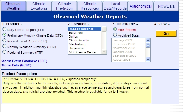
3.1 The image above shows the National Weather Service NWS Local Climate Data Products available under the “Observed Weather” tab. On a scale from 1 to 5, where 1 is Never and 5 is Very Often, please indicate how frequently you use this interface to access and download climate data from each of the products available through NOWData.
Daily Climate Report (CLI)
Preliminary Monthly Climate data (CF6)
Record Event Report (RER)
Monthly Weather Summary (CLM)
Regional Summary (RTP)
3.2. On a 10 point scale, where 1 means Poor and 10 means Excellent, please rate the NWS Local Climate Data Products available under the “Observed Weather” tab on the following:
Easy to understand
Easy to use
Eye-appealing
Clarity
Timeliness
Usefulness
Organization of information
Location selection
Variable selection
Length of data record
Meets my needs
NOWData
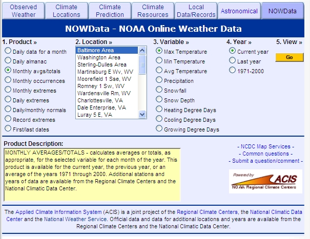
3.3. The image above shows the National Weather Service NOWData, an online tool that allows users to access recent climate data summaries and statistics. First, on a scale from 1 to 5 where 1 is Never and 5 is Very Often, please indicate how frequently you use this interface to access and download climate data from each of the products available through NOWData. Second, from the choices available below, please indicate your primary reason(s) for accessing climate data through NOWData. Programming Note: Both questions to be asked within one table.
NOWData Products
a. Daily data for a month _____
b. Daily almanac ___________
c. Monthly avgs/totals________
d. Monthly occurrences ______
e. Monthly extremes ________
f. Daily extremes ___________
g. Daily/monthly normals _____
h. Record extremes _________
i. First/last dates ____________
3.4. Please rate NOWData. On a 10 point scale, where 1 means Poor and 10 means Excellent, please rate the following:
Easy to understand
Easy to use
Eye-appealing
Clarity
Timeliness
Usefulness
Organization of information
Location selection
Variable selection
Length of data record
Meets my needs
3.5 Using a 1 to 10 scale, where 1 means Not Very Likely and 10 means Very Likely, how likely are you to make or change a decision based on information from NWS Observed Weather or NOWData products?
3.6 Please
comment on how you think the NWS can improve the overall climate data
services program to better serve your needs. (open-ended
response)
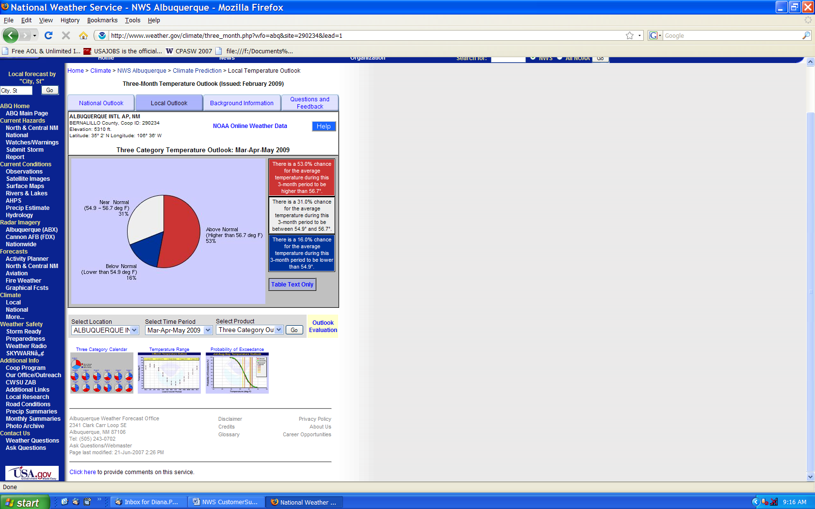
3.7 Using a 10 point scale where 1 means Poor and 10 means Excellent, please rate the above graphic of the Local 3-Month Temperature Outlook on the following Information and Content Characteristics:
Easy to understand
Easy to use
Eye-appealing
Clarity
Timeliness
Usefulness
Organization of information
Location selection
Variable selection
Length of data record
Meets my needs
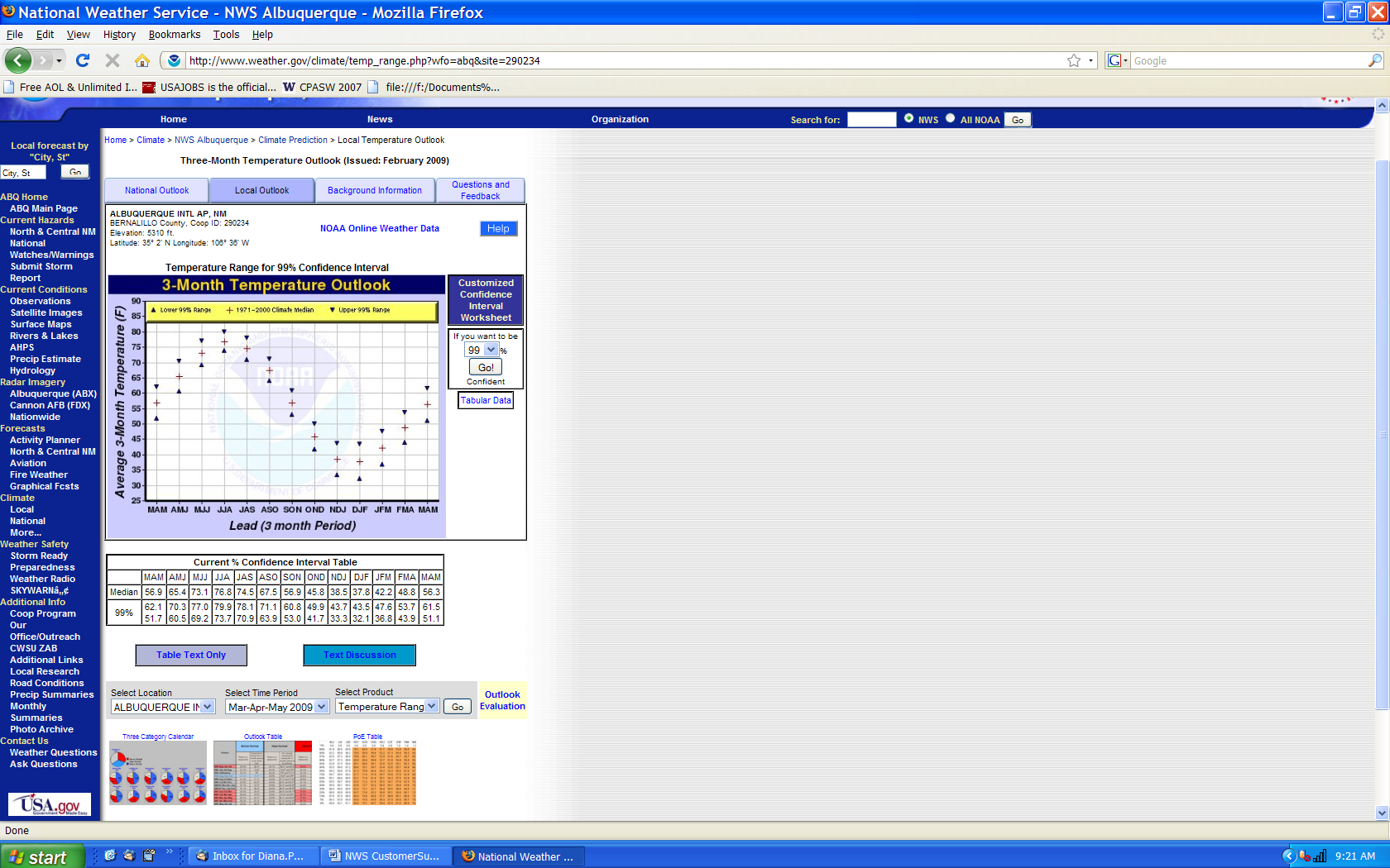
3.8 Using a 10 point scale where 1 means Poor and 10 means Excellent, please rate the above graphic on the following Information and Content Characteristics:
Easy to understand
Easy to use
Eye-appealing
Clarity
Timeliness
Usefulness
Organization of information
Location selection
Variable selection
Length of data record
Meets my needs

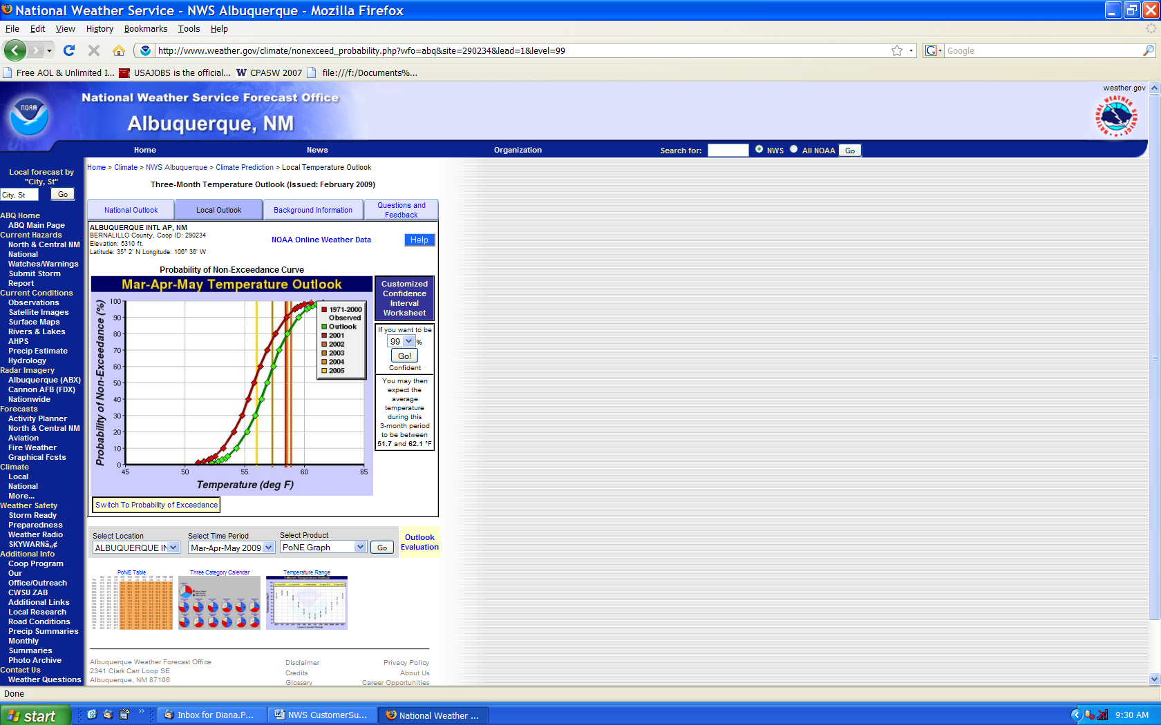
3.9 Using a 10 point scale where 1 means Poor and 10 means Excellent, please rate the above graphic on the following Information and Content Characteristics:
Easy to understand
Easy to use
Eye-appealing
Clarity
Timeliness
Usefulness
Organization of information
Location selection
Variable selection
Length of data record
Meets my needs
3.10 To help us develop NWS climate-sensitive decision support capabilities, please tell us what climate information you need for your decisions. (open-ended question)
(only if optional section question=2) Fire Weather Services
Dissemination
1. Which of the following methods do you use to receive or further disseminate your fire weather products? (Please select all that apply):
a. Internet Subscriber
Service
b. Web Site
c. Voice over Internet Protocol
d.
Satellite
e. IP Addressing (Signals to specific PC)
f.
Cable television
g. Broadcast television
h. Satellite
television
i. Home/Work Phone
j. Dedicated Phone line
k.
Cell Phone or Smart Phone
l. Pager
m.
AM/FM radio
n. Dedicated Short Range Radio
Communications
o. Satellite (e.g., XM, Sirus)
p. NOAA
Weather Radio
Local/Federal Interaction
2. Please think about the interactions you have had with Local, Regional or National NWS Fire Weather staff in the last year. On a scale from 1 to 10 where 1 means Poor and 10 means Excellent, rate the staff on the following:
a. Availability
b. Knowledge
c. Timeliness of responses
d.
Helpfulness of information provided
3. How important is the decision support information you receive from the National Weather Service Fire Weather program in helping you determine an appropriate course of action? Please use a scale of 1 to 10 where 1 means “not at all important” and 10 means “very important.”
Current Products
4. Please describe the frequency with which you use the following NWS fire weather services during the peak fire season for your area: (all products are hyperlinked to examples)
|
Multiple Times Each Day |
Once Per Day |
Once Per Week |
Once Per Month |
Never / Don’t Know |
a. Fire Weather Planning Forecast (FWF) |
|
|
|
|
|
b. Graphics and other web-based decision support tools such as point forecasts, hourly weather graph etc. |
|
|
|
|
|
c. Site-Specific (spot) forecasts |
|
|
|
|
|
d. Fire Weather Activity Planner |
|
|
|
|
|
e. Storm Prediction Center Fire Weather Outlooks |
|
|
|
|
|
f. Hazard Services (ex. Red Flag Warnings, Fire Weather Watches) |
|
|
|
|
|
g. Live and/or recorded weather briefings from your local NWS office. |
|
|
|
|
|
Note: Respondents will only receive questions for the products that they use.
Here are two examples of a Fire Weather Planning Forecast (FWF) product.
WESTERN EXAMPLE FIRE WEATHER FORECAST:
FIRE WEATHER PLANNING FORECAST
NATIONAL WEATHER SERVICE
...COOLER TODAY UNDER PARTLY CLOUDY SKIES...
...SUNNY AND WARMER FOR THE WEEKEND...
.DISCUSSION...
A WEAK WEATHER DISTURBANCE IS CROSSING THE DISTRICT THIS MORNING
WITH SCATTERED TO BROKEN CLOUDS BUT LITTLE IN THE WAY OF
PRECIPITATION. A FEW SPRINKLES OR SHOWERS ARE POSSIBLE HOWEVER OVER
NORTHERN PARTS OF THE DISTRICT THIS MORNING. HIGH PRESSURE REBUILDS
OVER THE AREA LATER TODAY.
IDZ401>404-210015-
WESTERN PAYETTE NATIONAL FOREST-EASTERN PAYETTE NATIONAL FOREST-
NORTHERN BOISE NATIONAL FOREST-SOUTHERN BOISE NATIONAL FOREST-
.TODAY...
SKY/WEATHER.........MOSTLY CLOUDY. SCATTERED RAIN SHOWERS...MAINLY
IN THE MORNING. CHANCE OF SHOWERS 30 PERCENT.
MAX TEMPERATURE.....49 TO 62.
24 HR TREND......ON AVERAGE...UNCHANGED.
MIN HUMIDITY........37 TO 52 PERCENT.
24 HR TREND......ON AVERAGE...4 PERCENT WETTER.
20-FOOT WINDS.......
VALLEYS..........LIGHT UPSLOPE WINDS LESS THAN 8 MPH IN THE
MORNING...BECOMING WEST 8 TO 12 MPH IN THE
AFTERNOON.
RIDGES...........NORTHWEST 8 TO 12 MPH.
HAINES INDEX........2 VERY LOW.
LAL.................1.
CWR /0.10 INCH/.....0 PERCENT.
SMOKE DISPERSAL:
MIXING HEIGHT......4000-6000 FT AGL.
TRANSPORT WINDS....NORTHWEST 5 TO 10 MPH.
.TONIGHT...
SKY/WEATHER.........MOSTLY CLEAR.
MIN TEMPERATURE.....28 TO 37.
24 HR TREND......ON AVERAGE...3 DEGREES COOLER.
MAX HUMIDITY........73 TO 97 PERCENT.
24 HR TREND......ON AVERAGE...UNCHANGED.
20-FOOT WINDS.......
VALLEYS..........LIGHT DOWNSLOPE WINDS LESS THAN 8 MPH.
RIDGES...........LIGHT WINDS LESS THAN 8 MPH IN THE
EVENING...BECOMING SOUTH AROUND 8 MPH AFTER
MIDNIGHT.
HAINES INDEX........2 VERY LOW.
LAL.................1.
CWR /0.10 INCH/.....0 PERCENT.
SMOKE DISPERSAL:
MIXING HEIGHT......0-100 FT AGL.
TRANSPORT WINDS....EAST 5 TO 10 MPH.
.FORECAST DAYS 3 THROUGH 7...
.SATURDAY...MOSTLY CLEAR. LOWS IN THE 20S TO UPPER 30S. HIGHS IN
THE 60S TO LOWER 70S. LIGHT WINDS LESS THAN 10 MPH.
.SUNDAY...MOSTLY CLEAR. LOWS IN THE UPPER 20S TO LOWER 40S. HIGHS
IN THE UPPER 50S TO LOWER 70S. LIGHT WINDS LESS THAN 10 MPH.
.MONDAY...MOSTLY CLEAR. LOWS IN THE 30S TO LOWER 40S. HIGHS IN
THE MID 50S TO UPPER 60S. SOUTH WINDS UP TO 10 MPH.
.TUESDAY...PARTLY CLOUDY. LOWS IN THE 20S TO UPPER 30S. HIGHS IN
THE 50S TO MID 60S.
.WEDNESDAY...PARTLY CLOUDY. LOWS IN THE 20S TO MID 30S. HIGHS IN
THE 50S TO LOWER 60S.
EASTERN EXAMPLE FIRE WEATHER FORECAST:
FIRE WEATHER PLANNING FORECAST NATIONAL WEATHER SERVICE
.DISCUSSION...
A BACK DOOR FRONT WILL AFFECT THE FORECAST AREA BY TONIGHT WITH A CHANCE OF THUNDERSTORMS IN THE SOUTHWEST VIRGINIA AND SOUTHEAST WEST VIRGINIA MOUNTAINS. THE FRONT WILL DRIFT SOUTHWEST THROUGH MUCH OF THE AREA BY FRIDAY MORNING. MEANWHILE LOW PRESSURE WILL STRENGTHEN AS IT MOVES INTO THE CENTRAL APPALACHIANS BY FRIDAY AFTERNOON
WVZ045-210345- GREENBRIER- INCLUDING THE CITY OF...LEWISBURG
TODAY TONIGHT FRI
CLOUD COVER PCLDY MCLDY MCLDY PRECIP TYPE TSTMS TSTMS SHOWERS CHANCE PRECIP (%) 20 40 40 TEMP 70 46 62 RH % 67 100 70 WND20FT2MIN/EARLY(MPH)LGT/VAR LGT/VAR LGT/VAR WND20FT2MIN/LATE(MPH) W 6 LGT/VAR SE 5 PRECIP AMOUNT 0.09 0.18 0.07 PRECIP DURATION 1 2 2 PRECIP BEGIN 11 AM CONTINUING CONTINUING PRECIP END CONTINUING CONTINUING CONTINUING MIXING HGT(FT-AGL) 4380 1060 TRANSPORT WND (MPH) SW 16 SW 17 VENT RATE (KT-FT) 61320 15900 DISPERSION (EVENING) VERY POOR LAL 3 3 1 HAINES INDEX 5 3 3
REMARKS...NONE.
.FORECAST FOR DAYS 3 THROUGH 7... .FRIDAY NIGHT AND SATURDAY...CLOUDY WITH RAIN SHOWERS LIKELY. LOWS IN THE MID 40S. HIGHS IN THE MID 50S. MINIMUM RH 89 PERCENT. WEST WINDS 5 TO 10 MPH. .SATURDAY NIGHT AND SUNDAY...MOSTLY CLOUDY WITH CHANCE OF RAIN SHOWERS. LOWS IN THE UPPER 30S. HIGHS IN THE LOWER 50S. MINIMUM RH 66 PERCENT. NORTHWEST WINDS 15 TO 20 MPH. .SUNDAY NIGHT AND MONDAY...PARTLY CLOUDY. CHANCE OF RAIN SHOWERS. LOWS IN THE MID 30S. HIGHS IN THE UPPER 40S. MINIMUM RH 59 PERCENT. NORTHWEST WINDS 15 TO 20 MPH. .MONDAY NIGHT AND TUESDAY...PARTLY CLOUDY WITH CHANCE OF RAIN SHOWERS. LOWS IN THE MID 30S. HIGHS AROUND 50. MINIMUM RH 66 PERCENT. SOUTHWEST WINDS 5 TO 10 MPH. .TUESDAY NIGHT AND WEDNESDAY...PARTLY CLOUDY. LOWS IN THE LOWER 30S. HIGHS IN THE LOWER 50S. MINIMUM RH 58 PERCENT. SOUTHWEST WINDS 5 TO 10 MPH.
|
4-a. Please think about the last time you used a Fire Weather Planning Forecast (FWF). Using a 10 point scale where 1 means Poor and 10 means Excellent, please rate the FWF on the following:
Helpfulness of information (1 to 10)
Timeliness of information (1 to 10)
Format is easy to understand (1 to 10)
Degree to which it meets my needs (1 to 10)
How do you use the Fire Weather Planning Forecast? (e.g., decision-making, other aspects of your daily work, etc.) (fill in the blank)
Here’s an example of a NWS Fire Weather Point Forecast product.
FIRE WEATHER POINT FORECAST MATRICES
NATIONAL WEATHER SERVICE
GAZ072-202115-
PIEDMONT NWR NORTH-JONES GA
33.13N 83.71W ELEV. 500 FT
1011 AM EST THU JAN 20 2011
DATE THU 01/20/11 FRI 01/21/11 SAT 01/22/11
UTC 3HRLY 09 12 15 18 21 00 03 06 09 12 15 18 21 00 03 06 09 12 15 18 21 00
EST 3HRLY 04 07 10 13 16 19 22 01 04 07 10 13 16 19 22 01 04 07 10 13 16 19
MAX/MIN 58 36 49 23 49
TEMP 55 58 47 43 39 37 36 41 48 48 36 31 27 25 23 34 46 49 37
DEWPT 33 35 37 37 34 30 26 20 14 11 13 16 15 15 16 14 12 11 11
MIN/MAX RH 40 82 21 72 21
RH 43 42 67 80 80 74 66 43 26 21 38 53 59 64 72 43 25 22 33
WIND DIR S SW SW W NW NW NW NW NW NW NW NW NW NW NW NW W W W
WIND DIR DEG 20 23 24 27 30 30 31 31 31 31 30 30 30 30 32 31 29 29 29
WIND SPD 4 6 3 6 10 12 13 13 13 13 4 3 3 3 2 4 5 5 3
WIND CHILL 32 29 26 33
CLOUDS B1 B1 B2 B2 OV OV FW FW FW FW FW FW FW FW FW FW FW FW FW
CLOUDS(%) 52 52 71 71 89 89 10 10 6 6 19 19 23 23 12 12 19 19 18
POP 12HR 0 30 5 10 10
QPF 12HR 0 0 0 0 0
RAIN C C
SNOW C
LAL 1 1 1 1 1
MIX HGT 2900 300 500 2100 2100
T WIND DIR SW SW NW NW N
T WIND SPD 9 9 14 28 19
DISPERSION 29 10 14 32 38
MAX LVORI 2 4 4 1 1
DATE SUN 01/23/11 MON 01/24/11 TUE 01/25/11 WED 01/26/11
UTC 6HRLY 06 12 18 00 06 12 18 00 06 12 18 00 06 12 18 00
EST 6HRLY 01 07 13 19 01 07 13 19 01 07 13 19 01 07 13 19
MIN/MAX 25 53 29 44 32 47 32 49
TEMP 28 25 50 41 33 29 43 38 34 32 45 40 34 32 47 39
DEWPT 15 19 22 24 23 24 28 32 32 30 30 30 29 28 26 24
MAX/MIN RH
RH 58 80 34 49 68 80 56 78 90 90 54 67 81 85 44 56
PWIND DIR NW SW SE NE NE N NW NW
WIND CHAR <15 <15 <15 <15 <15 <15 <15 <15
AVG CLOUDS FW FW FW FW B1 B1 OV OV B2 B2 B1 B1 B1 B1 SC SC
POP 12HR 5 10 10 40 40 30 10 10
RAIN C C C C C C
4-b. Please think about the last time you used a NWS fire weather point forecast. Using a 10 point scale where 1 means Poor and 10 means Excellent, please rate the product on the following:
Helpfulness of information (1 to 10)
Timeliness of information (1 to 10)
Format is easy to understand (1 to 10)
Degree to which it meets my needs (1 to 10)
How do you use the fire weather point forecast? (e.g., decision-making, other aspects of your daily work, etc.) (fill in the blank)
Here’s an example of a Site-Specific (spot) Forecast product.

4-c. Now, please think about the last time you used Site-Specific (spot) forecasts. Using a 10 point scale where 1 means Poor and 10 means Excellent, please rate the spot forecasts on the following:
Helpfulness of information (1 to 10)
Timeliness of information (1 to 10)
Format is easy to understand (1 to 10)
Degree to which it meets my needs (1 to 10)
How do you use site-specific spot forecasts? (e.g., decision-making, other aspects of your daily work, etc.) (fill in the blank)
Here’s an example of a Weather Activity Planner product.

4-d. Please think about the last time you used a Weather Activity Planner for fire weather. Using a 10 point scale where 1 means Poor and 10 means Excellent, please rate the Weather Planner on the following:
Helpfulness of information (1 to 10)
Timeliness of information (1 to 10)
Format is easy to understand (1 to 10)
Degree to which it meets my needs (1 to 10)
How do you use the Weather Activity Planner? (e.g., decision-making, other aspects of your daily work, etc.) (fill in the blank)
Here’s an example of a Storm Prediction Center Outlook product.
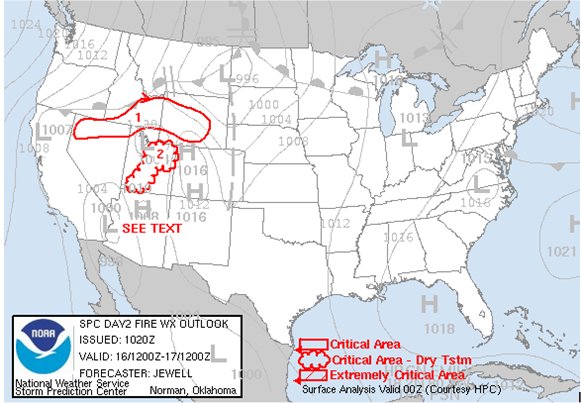

4-e. Please think about the last time you used a Storm Prediction Center Outlook (available at http://www.spc.noaa.gov/fire/). Using a 10 point scale where 1 means Poor and 10 means Excellent, please rate Fire Weather Outlooks on the following:
Helpfulness of information (1 to 10)
Timeliness of information (1 to 10)
Format is easy to understand (1 to 10)
Degree to which it meets my needs (1 to 10)
How do you use the Storm Prediction Center Outlooks? (e.g., decision-making, other aspects of your daily work, etc.) (fill in the blank)
Red Flag Warning Program
The intent of the NWS Red Flag Warning and Fire Weather Watch Program is to provide land management agencies with appropriate notification of the likelihood that weather conditions will produce widespread new fire ignitions or result in control problems with existing fires.
5. Do you have a well established fuels input into the Red Flag Program?
Yes
No (ask 5a)
Not Sure
5a. If no, why not?
6. Fire Weather Watches are issued to alert fire and land management agencies to the possibility of red flag conditions, generally 24 to 72 hours in advance of the expected conditions.
Please think about the last time you used a Fire Weather Watch to prepare for a period of critical fire weather. Using a 10 point scale where 1 means Poor and 10 means Excellent, please rate the following:
a. The usefulness of the watch information
b. The amount of time you had to act
c. How clearly the watch information described the conditions to expect
7. Did you know what action to take when you saw the Fire Weather Watch?
Yes
No, if no, why?
Please describe actions usually taken
8. How often do you take action based on a Fire Weather Watch?
a. Always
b. Usually
c. Sometimes
d. Rarely
e. Never (skip to #10)
9. When a Fire Weather Watch is issued, at what timescale do you typically take action?
a. At the Watch issuance
b. 36-48 hours before the event
c. 24 hours before the event
d. 12 hours before the event
10. A Red Flag Warning is used to alert fire and land management agencies that red flag conditions exist or are imminent.
Please think about the last time you used a Red Flag Warning to prepare for a period of critical fire weather. Using a 10 point scale where 1 means Poor and 10 means Excellent, please rate the following:
a. The usefulness of the warning information
b. The amount of time you had to act
c. How clearly the warning information described the conditions to expect
11. Did you know what action to take when you saw the Red Flag Warning?
Yes
No, if no, why?
Please describe actions usually taken
12. How often do you take action based on a Red Flag Warning?
a. Always
b. Usually
c. Sometimes
d. Rarely
e. Never
13. Do you have procedures that are automatically invoked upon the issuance of a NWS Fire Weather Watch or Red Flag Warning?
Yes
b. No - why not? (fill in the blank) (skip to 16)
14. When a Red Flag Warning is issued, at what timescale do you typically take action?
a. At the Warning issuance
b. 24 hours before the event
c. 12 hours before the event
d. At event onset
15. Which of the following do the automatic procedures involve? (Select all that apply)
a. Bringing on extra staff
b. Moving or pre-positioning firefighting resources
c. Adjusting planning levels
d. Extending normal operating hours
e. Limiting or restricting land usage
f. Other (please specify)
16. Please comment on how you think the NWS can improve its Red Flag Warning and Fire Weather Watch Program to better serve your needs.
17. Please provide any helpful comments on how you utilize your favorite/most helpful NWS products. Please name the product and briefly describe the way(s) you use the fire weather decision support service.
(only if Q89=3) Hydrologic Services
Current Services
Referring specially to hydrologic-related text products provided by the NWS, on a 10-point scale, where 1 means “Poor” and 10 means “Excellent”, please rate each of the hydrologic-related text products on the following: (11=”Not familiar with this text product”)
|
Ease of Understanding |
Usefulness |
(Mouse over Flood Watches displays Flood Watch example shown in the Appendix.) |
|
|
(Mouse over Flash Flood Watches displays Flash Flood Watch example shown in the Appendix.) |
|
|
(Mouse over Flood Warnings displays Flood Warning example shown in the Appendix.) |
|
|
(Mouse over Flash Flood Warnings displays Flash Flood Warning example shown in the Appendix.) |
|
|
(Mouse over Flood Advisories displays Flood Advisory example shown in the Appendix.) |
|
|
(Mouse over Hydrologic Statements displays Hydrologic Statement example shown in the Appendix.) |
|
|
(Mouse over Short-Term Hydrologic Outlooks displays Short-term Hydrologic Outlook example shown in the Appendix.) |
|
|
(Mouse over Long-Term Hydrologic Outlooks displays Long-Term Hydrologic Outlook example shown in the Appendix.) |
|
|
(Mouse over River and Lake Forecast Products displays River and Lake Forecast Product example shown in the Appendix.) |
|
|
(Mouse over Hydrometeorological Data Products and Summaries displays Hydrometeorological Data Product and Summary example shown in the Appendix.) |
|
|
A flood warning is issued by the National Weather Service to provide advance notice of flooding. This gives users time to initiate life-saving and mitigation actions such as evacuation and removal of goods and belongings. A flash flood warning is issued to provide advance notice of dangerous, short-fused flood events which require immediate mitigation actions such as evacuation to higher ground. On a 10 point scale where 1 means Not Important at all and 10 means Very Important, please rate the importance of the distinction between a flood warning and a flash flood warning.
The NWS currently issues Hydrologic Outlooks, Flood Watches, and Flash Flood Watches to give users lead time to consider response options and execute mitigation activities and Flood Advisories to communicate elevated river/stream flow or ponding of water requiring less drastic action to protect life and property. Which of the following actions would most meet your needs?
Simplify product suite. Instead of issuing Hydrologic Outlooks, Flood Watches, Flash Flood Watches, and Flood Advisories, the NWS would issue one product, a Hydrologic/High Water Alert, for all of these types of events. Specific information on the type of high water event that is possible or occurring would be included in the Hydrologic/High Water Alert. The NWS would continue issuing Flood and Flash Flood Warnings to provide advance notice of more dangerous flood events
Maintain current product suite. The NWS continues to issue Hydrologic Outlooks, Flood Watches, Flash Flood Watches, Flood Advisories, Flood Warnings, and Flash Flood Warnings using current definitions and methodologies.

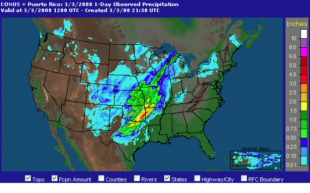
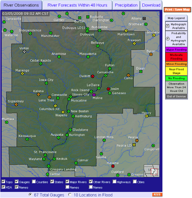

The National Weather Service provides a suite of hydrologic information on the Internet, as represented by the above images, primarily in graphical format as part of its Advanced Hydrologic Prediction Service (AHPS). How frequently do you visit these web pages?
Several times per day
Once per day
Once per week
Once per month
Do not use (exit Hydrologic Services portion of survey)
Not familiar with this information (exit Hydrologic Services portion of survey)
How easy is it to find the information you are looking for on the AHPS web pages? On a 10-point scale where 1 means Very Difficult and 10 means Very Easy, please rate how easy it is for you to find information on the AHPS web pages.

The map above shows the flood status at all river forecast locations in the Quad Cities Weather Forecast Office’s Hydrologic Service Area. On a 10-point scale where 1 means Not at all Useful and 10 means Very Useful, please rate the usefulness of being able to overlay the following observations, analyses, and forecasts on the map.
Flood Watches
Flood Warnings
Radar
Satellite
Observed precipitation
Forecast precipitation
Snow depth
Snow water equivalent
River ice
Soil moisture
Evapotranspiration
Water quality
Runoff
Groundwater
Flash flood guidance
Drought conditions
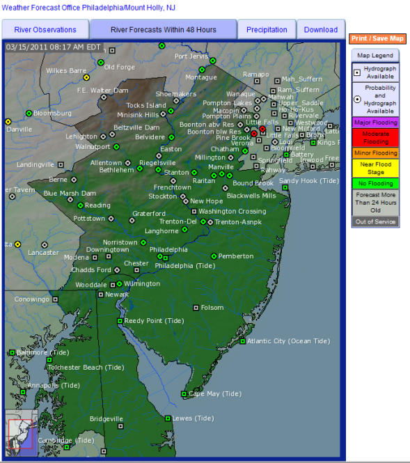
The map above depicts the maximum stage/flow the rivers across the Philadelphia/Mount Holly, NJ hydrologic service area are forecast to reach over the next 48 hours. On a 10-point scale where 1 means Not at all Useful and 10 means Very Useful, how useful would it be for you to have the ability to display the maximum stage/flow forecasts within the entire forecast period (7 days in some cases) and within 24, 72, 96, 120, and 144 hours.
The hydrograph above shows observed and forecast stage/flow observations for the Rock River at Moline. On a 10-point scale where 1 means Not at all Useful and 10 means Very Useful, please rate the usefulness of being able to overlay the following observations and statistics on the hydrograph.
Record low flow, stage, or pool for a specified period of record
Normal daily flow, stage, or pool for a specified period of record
Seven-day minimum flow with a recurrence interval of 10 years (Mouse over this question to display seven-day minimum flow with a recurrence interval of 10 years plotted on a hydrograph. This hydrograph appears in the Appendix.)
The discharge that has been exceeded 10 percent of the time for a designated period (Mouse over this question to display discharge that has been exceeded 10 percent of the time for a designated period plotted on a hydrograph. This hydrograph appears in the Appendix.)
The discharge that has been exceeded 25 percent of the time for a designated period (Mouse over this question to display discharge that has been exceeded 25 percent of the time for a designated period plotted on a hydrograph. This hydrograph appears in the Appendix.)
The discharge that has been exceeded 75 percent of the time for a designated period (Mouse over this question to display discharge that has been exceeded 75 percent of the time for a designated period plotted on a hydrograph. This hydrograph appears in the Appendix.)
The discharge that has been exceeded 90 percent of the time for a designated period (Mouse over this question to display discharge that has been exceeded 90 percent of the time for a designated period plotted on a hydrograph. This hydrograph appears in the Appendix.)
Inundation Mapping and Uncertainty
Inundation where river is 18 feet above flood

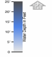
The map above shows the areal extent and depth of floodwaters when the stage (river level) at Tarboro, NC on the Tar River is 18 ft above flood level. This is a new service not available everywhere. Using a 10-point scale where 1 means Not at all Useful and 10 means Very Useful, please rate the usefulness of this information in your decision making processes.
Integrated Water Resources Science and Services (IWRSS)
The National Oceanic and Atmospheric Administration (NOAA) is developing the IWRSS (Integrated Water Resources Science and Services) consortium – an innovative partnership of federal agencies with complementary operational missions in water science, observation, prediction, and management. The IWRSS consortium, which initially consists of NOAA, the U.S. Army Corps of Engineers, and the U.S. Geological Survey, may eventually include as many as 20 federal agencies and create a single web portal where one could access water information from all of the participating federal agencies. Using a 10-point scale where 1 means Not at all Useful and 10 means Very Useful, please rate the usefulness of having a single web portal for water information.
Appendix
Flood Watch
WGUS61 KRNK 270652
FFARNK
URGENT - IMMEDIATE BROADCAST REQUESTED
FLOOD WATCH
NATIONAL WEATHER SERVICE BLACKSBURG VA
252 AM EDT TUE MAY 27 2003
NCZ003>006-019-020-VAZ022>024-032>035-043>047-058-059-271300- /O.NEW.KRNK.FA.A.0002.030527T1400Z-030528T0800Z/ /00000.0.ER.000000T0000Z.000000T0000Z.000000T0000Z.OO/
AMHERST-APPOMATTOX-BEDFORD-BOTETOURT-BUCKINGHAM-CAMPBELL-CASWELL-
CHARLOTTE-FRANKLIN-HALIFAX-HENRY-PATRICK-PITTSYLVANIA-ROANOKE-
ROCKBRIDGE-ROCKINGHAM-STOKES-SUNNY-WILKES-YADKIN-
252 AM EDT TUE MAY 27 2003
...FLOOD WATCH IN EFFECT FROM 10 AM THIS MORNING THROUGH WEDNESDAY MORNING...
THE NATIONAL WEATHER SERVICE IN BLACKSBURG HAS ISSUED A
* FLOOD WATCH FOR PORTIONS OF SOUTHWESTERN VIRGINIA AND NORTHWEST
NORTH CAROLINA...INCLUDING THE FOLLOWING COUNTIES IN VIRGINIA... AMHERST...APPOMATTOX...BEDFORD...BOTETOURT...BUCKINGHAM...CAMPBELL...
CHARLOTTE...FRANKLIN...HALIFAX...HENRY...PATRICK...PITTSYLVANIA...
ROANOKE AND ROCKBRIDGE.
IN NORTH CAROLINA...CASWELL...ROCKINGHAM...STOKES...SURRY...WILKES
AND YADKIN.
* FROM 10 AM THIS MORNING THROUGH WEDNESDAY MORNING.
* LOW PRESSURE IS EXPECTED TO STRENGTHEN OVER THE CAROLINAS AND MOVE EAST THIS AFTERNOON AS A POTENT UPPER DISTURBANCE OVER KENTUCKY MOVES OVER THE SOUTHERN APPALACHIANS. AS A RESULT RAIN IS EXPECTED TO REDEVELOP AND BECOME HEAVY AT TIMES ALONG AND EAST OF THE BLUE RIDGE LATER THIS MORNING AND THIS AFTERNOON.
* LOWER PORTIONS OF THE DAN AND ROANOKE RIVERS ARE ALREADY IN OR NEAR FLOOD DUE TO HEAVY RAINFALL SUNDAY...AND ADDITIONAL RAINFALL COULD EASILY CAUSE SHARP RISES ON THESE RIVERS. AREA CREEKS AND STREAMS ARE ALSO RUNNING HIGH AND COULD FLOOD WITH MORE HEAVY RAIN.
PRECAUTIONARY/PREPAREDNESS ACTIONS...
REMEMBER...A FLOOD WATCH MEANS THAT FLOODING IS POSSIBLE BUT NOT IMMINENT IN THE WATCH AREA.
&&
$$
Flash Flood Watch
WGUS63 KFGF 190900
FFASGF
URGENT - IMMEDIATE BROADCAST REQUESTED
FLOOD WATCH
NATIONAL WEATHER SERVICE SPRINGFIELD MO
300 AM CST WED MAR 19 2003
MOZ066-077-088-093-094-101-102-191500-
/O.NEW.KSGF.FF.A.0002.030319T1500Z-030320T2200Z/ /00000.0.ER.000000T0000Z.000000T0000Z.000000T0000Z.OO/
BARRY-BARTON-JASPER-LAWRENCE-MCDONALD-NEWTON-VERNON-
300 AM CST WED MAR 19 2003
...FLASH FLOOD WATCH IN EFFECT FROM 9 AM THIS MORNING THROUGH
THURSDAY AFTERNOON...
THE NATIONAL WEATHER SERVICE IN SPRINGFIELD HAS ISSUED A
* FLASH FLOOD WATCH FOR A PORTION OF SOUTHWESTERN MISSOURI...
INCLUDING THE FOLLOWING COUNTIES...BARRY...BARTON...JASPER...
LAWRENCE...MCDONALD...NEWTON AND VERNON.
* FROM 9 AM THIS MORNING THROUGH THURSDAY AFTERNOON.
* A STRONG STORM SYSTEM MOVING NORTHEAST ACROSS THE CENTRAL PLAINS WILL CONTINUE TO PUMP MOISTURE NORTHWARD FROM THE GULF OF MEXICO. A LARGE BAND OF RAIN AND THUNDERSTORMS WILL CONTINUE TO ROTATE NORTHWESTWARD AROUND THIS UPPER LOW. MODERATE TO HEAVY RAIN AND OCCASIONAL THUNDERSTORMS ASSOCIATED WITH THIS BAND WILL CONTINUE OVER THE WATCH AREA MUCH OF TODAY. WIDESPREAD RAINFALL AMOUNTS OF 1 TO 2 INCHES ARE LIKELY IN THE WATCH AREA TODAY...WITH LOCALLY HEAVIER AMOUNTS OF 3 OR MORE INCHES POSSIBLE.
PRECAUTIONARY/PREPAREDNESS ACTIONS...
REMEMBER...A FLASH FLOOD WATCH MEANS THAT FLOODING IS POSSIBLE BUT NOT IMMINENT IN THE WATCH AREA. PERSONS IN SOUTHWESTERN MISSOURI SHOULD BE AWARE OF THE POSSIBILITY FOR HEAVY RAINFALL AND FLASH FLOODING... CHECK YOUR PREPAREDNESS REQUIREMENTS...ESPECIALLY IF YOU HAVE INTERESTS ALONG RIVERS IN THE AREA. KEEP INFORMED...AND BE READY FOR ACTION IF FLOODING IS OBSERVED OR IF A FLASH FLOOD WARNING IS ISSUED. STAY TUNED TO NOAA WEATHER RADIO...COMMERCIAL MEDIA OR YOUR CABLE TELEVISION PROVIDER FOR WATCH UPDATES AND POSSIBLE WARNINGS.
&&
$$
Flood Warning
WGUS41 KILN 241202
FLWILN
BULLETIN - IMMEDIATE BROADCAST REQUESTED
FLOOD WARNING
NATIONAL WEATHER SERVICE WILMINGTON OH
802 AM EDT THU AUG 24 2000
-241800- /O.NEW.KILN.FA.W.0011.000824T1202Z-000825T0000Z/ /00000.0.ER.000000T0000Z.000000T0000Z.000000T0000Z.OO/
ADAMS OH-
802 AM EDT THU AUG 24 2000
THE NATIONAL WEATHER SERVICE IN WILMINGTON HAS ISSUED A
* FLOOD WARNING FOR SMALL STREAMS IN...
ADAMS COUNTY IN SOUTHERN OHIO...
* UNTIL 800 PM THIS EVENING
* AT 800 AM EDT...WEATHER SERVICE DOPPLER RADAR INDICATED THAT OVER 3 INCHES OF RAIN HAD FALLEN OVER PARTS OF THE COUNTY. AN ADDITIONAL ONE OR TWO INCHES ARE POSSIBLE THROUGHOUT THE DAY. AS A RESULT... HIGH WATER LEVELS CAN BE EXPECTED INTO THE EVENING HOURS. SOME LOCATIONS IN THE WARNING AREA INCLUDE WEST UNION AND BLUE CREEK.
PRECAUTIONARY/PREPAREDNESS ACTIONS...
A FLOOD WARNING MEANS THAT FLOODING IS IMMINENT OR HAS BEEN REPORTED. IF FLOODING IS OBSERVED...ACT QUICKLY. DO NOT STAY IN AREAS SUBJECT
TO FLOODING WHEN WATER BEGINS RISING. NEVER DRIVE CARS...TRUCKS OR
SPORT UTILITY VEHICLES THROUGH FLOODED AREAS. THE WATER MAY BE TOO
DEEP TO ALLOW FOR SAFE PASSAGE.
&&
LAT...LON 3900 8327 3904 8330 3905 8338 3901 8360 3901 8368 3863 8370 3869 8365 3866 8362 3868 8352 3866 8345 3864 8337 3863 8332 3858 8328 3860 8327
$$
Flash Flood Warning
WGUS51 KOKX 141655
FFWOKX
NYC103-142000-
/O.NEW.KOKX.FF.W.0005.000814T1655Z-000814T2000Z/ /00000.0.ER.000000T0000Z.000000T0000Z.000000T0000Z.OO/
BULLETIN - EAS ACTIVATION REQUESTED
FLASH FLOOD WARNING
NATIONAL WEATHER SERVICE NEW YORK NY
1255 PM EDT MON AUG 14 2000
THE NATIONAL WEATHER SERVICE IN UPTON HAS ISSUED A
* FLASH FLOOD WARNING FOR...
SOUTHWEST SUFFOLK COUNTY IN SOUTHEASTERN NEW YORK STATE...
* UNTIL 400 PM EDT
* AT 1254 PM NATIONAL WEATHER SERVICE DOPPLER RADAR INDICATED THUNDERSTORMS MOVING NORTHWEST TOWARD THE WARNED AREA. RAINFALL RATES FROM 2 TO 3 INCHES PER HOUR WILL CAUSE FLASH FLOODING OF LOW LYING AND POOR DRAINAGE AREAS. THE HEAVY RAINS SHOULD END BY 200 PM EDT AND IT WILL TAKE ANOTHER HOUR OR TWO FOR THE FLOODING TO DISSIPATE.
PRECAUTIONARY/PREPAREDNESS ACTIONS...
DO NOT DRIVE YOUR VEHICLE INTO AREAS WHERE THE WATER COVERS THE ROADWAY. MOVE TO HIGHER GROUND IMMEDIATELY.
REPORT SEVERE WEATHER TO THE NEAREST LAW ENFORCEMENT AGENCY. THEY WILL RELAY YOUR REPORT TO THE NATIONAL WEATHER SERVICE FORECAST
OFFICE IN UPTON.
&&
LAT...LON 4153 7264 4131 7255 4138 7190 4159 7198
$$
Flood Advisory
WGUS84 KSJT 281256
FLSSJT
FLOOD ADVISORY
NATIONAL WEATHER SERVICE SAN ANGELO TX
755 AM CDT TUE MAY 28 2002
TXC441-281500-
/O.NEW.KSJT.FA.Y.0005.020528T1255Z-020528T1500Z/ /00000.N.ER.000000T0000Z.000000T0000Z.000000T0000Z.OO/
TAYLOR TX-
755 AM CDT TUE MAY 28 2002
THE NATIONAL WEATHER SERVICE IN SAN ANGELO HAS ISSUED AN
* URBAN AND SMALL STREAM FLOOD ADVISORY FOR...
TAYLOR COUNTY IN CENTRAL TEXAS...
* UNTIL 1000 AM CDT TUESDAY
* AT 750 AM CDT...WEATHER SERVICE RADAR INDICATED THUNDERSTORMS WITH LOCALLY HEAVY RAINFALL ACROSS CENTRAL AND NORTHERN TAYLOR COUNTY. RAINFALL BETWEEN 1 TO 2 INCHES HAS FALLEN IN ABILENE SINCE 700 AM WITH ANOTHER ONE HALF INCH POSSIBLE THROUGH MID MORNING.
* LOW LYING AND POOR DRAINAGE AREAS ACROSS THE CITY OF ABILENE MAY BECOME FLOODED AND IMPASSABLE.
PRECAUTIONARY/PREPAREDNESS ACTIONS...
MOTORISTS ACROSS ABILENE SHOULD USE EXTREME CAUTION WHEN TRAVELING ACROSS THE CITY. DO NOT ATTEMPT TO CROSS AREAS WHERE WATER OF UNKNOWN DEPTH COVERS THE ROAD.
&&
LAT...LON 3253 10014 3208 10014 3208 9960 3253 9960
$$
Hydrologic Statement
FGUS84 KFWD 110117
RVSFWD
TXC119-223-120100-
HYDROLOGIC STATEMENT
NATIONAL WEATHER SERVICE FORT WORTH TX
817 PM CDT WED APR 10 2002
THIS STATEMENT UPDATES INFORMATION FOR THE FOLLOWING LOCATIONS ON THE SULPHUR RIVER...COOPER
FOR THE SOUTH SULPHUR RIVER NEAR COOPER...THE STAGE AT 715 PM WEDNESDAY WAS 15.7 FEET. FLOOD STAGE IS 16.0 FEET. THE RIVER IS FORECAST TO HOLD AROUND 15.7 FEET...JUST BELOW FLOOD STAGE FOR THE NEXT SEVERAL DAYS. IF THE RIVER REACHES OR EXCEEDS 16.0 FEET...MINOR OUT OF BANK FLOODING WILL OCCUR AND A FEW RURAL ROADS WILL BEGIN TO FLOOD. MINOR FLOODING WILL ALSO OCCUR TO FARM AND RANCH LAND ADJACENT TO THE RIVER.
&&
FLD OBSERVED FORECAST 7 PM
LOCATION STG STG DAY TIME THU FRI SAT
SULPHUR RIVER
COOPER 16 15.7 WED 7 PM 15.7 15.6 15.5
$$
Short-term Hydrologic Outlook
FGUS73 KSGF 102135
ESFSGF
MOC055-056-058-060>062-110400-
HYDROLOGIC OUTLOOK
NATIONAL WEATHER SERVICE SPRINGFIELD MO
335 PM CST FRI DEC 10 1999
...ANOTHER HEAVY RAINMAKER TO HIT THE OZARKS COULD PRODUCE FLOODING EARLY NEXT WEEK...
OVER THE PAST COUPLE OF WEEKS...SIGNIFICANT RAINFALL HAS FALLEN ACROSS THE OZARKS. AS A RESULT...MOST OF SOUTHWEST MISSOURI IS ALMOST BACK TO NORMAL RAINFALL...AND IN SOME CASES ABOVE NORMAL. THROUGH DECEMBER 10...SPRINGFIELD HAS RECEIVED 6.84 INCHES AND MANY AREAS OF THE OZARKS HAVE RECEIVED MORE THAN EIGHT INCHES. THE NORMAL RAINFALL FOR SPRINGFIELD IN DECEMBER IS 3.16 INCHES.
BEGINNING MONDAY AND EARLY TUESDAY...THE OZARKS WILL RECEIVE ANOTHER SOAKING RAIN. CURRENT WEATHER MODELS INDICATE A STORM TRACK ACROSS NORTHERN ARKANSAS AND SOUTHERN MISSOURI...BASICALLY THE SAME TRACK TAKEN BY THE RECENT STORMS. THIS MEANS ABUNDANT GULF MOISTURE WILL BE PULLED INTO THE STORM AND DEPOSIT UPWARDS OF ONE TO TWO INCHES ACROSS MOST SECTIONS OF SOUTHERN MISSOURI.
FLOODING MAY OCCUR BECAUSE THE GROUND IS SATURATED FROM RECENT RAINS. LOW WATER CROSSINGS AND SMALL STREAMS COULD SWELL TO SMALL RAGING STREAMS OF WATER. RIVERS...MAINLY ACROSS SOUTHERN MISSOURI... COULD RISE CLOSE TO OR ABOVE FLOOD STAGE BY NEXT TUESDAY.
THE HAZARDOUS WEATHER OUTLOOK PRODUCT WILL BE UPDATED WITH THE LATEST INFORMATION THROUGHOUT THE WEEKEND. ANOTHER SOURCE OF CURRENT WEATHER INFORMATION FOR SOUTHERN MISSOURI IS THROUGH OUR WEB PAGE AT:
WWW.CRH.NOAA.GOV/SGF/.
$$
Long-term Hydrologic Outlook
FGUS74 KHGX 171636
ESFHGX
180436-
PROBABILISTIC HYDROLOGIC OUTLOOK
NATIONAL WEATHER SERVICE HOUSTON/GALVESTON, TX
1136 AM CDT THU MAR 17 2011
...ADVANCED HYDROLOGIC PREDICTION SERVICE (AHPS) LONG RANGE PROBABILISTIC OUTLOOK FOR THE COLORADO RIVER BASIN IN SOUTHEAST TEXAS...
THE HOUSTON/GALVESTON NATIONAL WEATHER SERVICE OFFICE HAS IMPLEMENTED ADVANCED HYDROLOGIC PREDICTION SERVICE (AHPS) FOR THE COLORADO RIVER BASIN IN SOUTHEAST TEXAS. AHPS ENABLES THE NATIONAL WEATHER SERVICE TO PROVIDE LONG-RANGE PROBABILISTIC OUTLOOKS. THIS SERVICE IS ALSO AVAILABLE ON THE INTERNET.
IN THE TABLE BELOW...THE 90 THROUGH 10 PERCENT COLUMNS INDICATE THE CHANCE THE RIVER COULD RISE ABOVE THE LISTED STAGE LEVELS IN THE NEXT 90 DAYS. EXAMPLE: THE COLORADO RIVER AT WHARTON HAS A FLOOD STAGE OF 39 FEET. THERE IS A 50 PERCENT CHANCE THE WHARTON FORECAST POINT WILL RISE ABOVE 16.9 FEET DURING THE NEXT 90 DAYS.
CHANCE OF EXCEEDING STAGES AT SPECIFIC LOCATIONS
VALID [3/17/2011 - 6/15/2011]
LOCATION FS(FT) 90% 80% 70% 60% 50% 40% 30% 20% 10%
----------------------------------------------------------------
COLORADO RIVER
COLUMBUS 17.0 10.8 12.2 13.6 15.6 16.6 17.4 20.4 23.5 30.4
WHARTON 18.0 9.8 12.0 13.9 15.8 16.9 18.4 21.3 24.0 31.8
BAY CITY 16.0 4.8 7.4 9.6 11.0 13.0 14.6 18.3 21.0 25.2
THIS LONG-RANGE PROBABILISTIC OUTLOOK CONTAINS NUMBERS THAT ARE CALCULATED USING MULTIPLE SCENARIOS FROM 50 YEARS OF HISTORICAL CLIMATOLOGICAL AND STREAM FLOW DATA. THESE NUMBERS ALSO TAKE INTO ACCOUNT CURRENT CONDITIONS OF THE RIVER AND SOIL MOISTURE. BY PROVIDING THE COMPLETE RANGE OF PROBABILISTIC NUMBERS...THE LEVEL OF RISK ASSOCIATED WITH LONG-RANGE PLANNING DECISIONS CAN BE DETERMINED.
ADDITIONAL SUPPORTIVE DATA AND EXPLANATION ARE AVAILABLE ON THE INTERNET AT: WWW.SRH.WEATHER.GOV/CGI-BIN/AHPS.CGI?HGX (INTERNET ADDRESS IS ALL LOWER CASE).
LONG-RANGE PROBABILISTIC OUTLOOKS ARE ISSUED AROUND THE THIRD THURSDAY OF EVERY MONTH.
$$
River and Lake Forecast Product
FGUS51 KLWX 011706
RVDLWX
MDC001>002-009-DCC001-021700-
DAILY RIVER AND LAKE SUMMARY
NATIONAL WEATHER SERVICE BALTIMORE MD/WASHINGTON DC
1206 PM EST THU MAR 01 2001
.B WBC 0301 DC01030112
DH12/HG/DRH+24/HGIFF/DRH+48/HGIFF/DRH+72/HGIFF
: STATION FLOOD 7AM 24-HR 7AM
: ID NAME STAGE STAGE CHANGE FORECASTS
: FRI SAT SUN
:POTOMAC RIVER
HPFW2 :HARPERS FERRY 18.0 : 11.44/: 0.22: 11.40 /11.32 /9.75/
LITM2 :LITTLE FALLS 10.0 : 3.71/: 0.04: 3.70 / 3.60 /M /
:
.END
:
.B WBC 0301 DH12/HP
: FULL WATER OBSERVED 24-HR
:ID LAKE NAME POOL ELEV. DAY TIME CHANGE
KERV2: JOHN H. KERR 320 : 295.6 : THU 7 AM -0.2
:
.END
$$
Hydrometeorological Data Product and Summary
CSUS46 KMTR 051725
HYMMTR
CAC053-055-069-075-085-087-097-061800-
MONTHLY HYDROMETEOROLOGICAL DATA SUMMARY
NATIONAL WEATHER SERVICE SAN FRANCISCO CA
925 AM PST FRI APR 5 2002
.B MTR 0331 P DH24/PPM
:
: MONTHLY PRECIPITATION FOR SF BAY AREA AND CENTRAL COAST
:
ANGC1 3.69 :ANGWIN PACIFIC UNION COLLEGE
BISC1 4.62 :BIG SUR STATE PARK
FORC1 3.32 :FORT ROSS
HLDC1 3.46 :HEALDSBURG FIRE DEPT
KICC1 0.58 :KING CITY
MHMC1 3.86 :MOUNT HAMILTON
NSHC1 2.63 :NAPA STATE HOSPITAL
PANC1 0.90 :PANOCHE 2W
PRSC1 0.80 :PRIEST VALLEY
SFOC1 2.27 :SAN FRANCISCO DOWNTOWN
SCRC1 3.52 :SANTA CRUZ
STSC1 2.43 :SANTA ROSA
WVIC1 1.51 :WATSONVILLE WATERWORKS
.END
$$
Hydrograph

(re-ask optional section question)
(only if optional section question=4) Tsunami Services
What is your experience with tsunamis?
I have experienced a damaging tsunami.
I have been in a location that has been placed in a tsunami warning, and a destructive tsunami occurred.
I have been in a location that has been placed in a tsunami warning, and no destructive tsunami occurred.
I have been in a location that has been placed in a tsunami advisory that resulted in damage to harbors, beaches, or other locations.
I have been in a location that has been placed in a tsunami advisory that did not result in damage to harbors, beaches, or other locations.
I have been in a location that has been placed in a tsunami watch.
I have not experienced a tsunami.
Where do you get your tsunami products from?
Commercial weather vendors? (CNN, Weather Channel, Radio, etc.)
PDA or other mobile device?
Tsunami Warning Center text/email/web-based products?
National Weather Service Forecast Office
NOAA Weather Radio
Emergency Alert System
Media (television, radio)
U.S. Coast Guard broadcasts
Local notification systems (sirens, reverse 911, etc.)
Other
If you answered yes to 1a, 1b, 1c, 1d, 1e, and/or 1f, did you know how to respond to the tsunami message?
Yes.
No.
Maybe.
I did not receive a tsunami message.
If you answered yes to 2a, 2b, 2c, 2d, 2e, and/or 2f, did you receive further instructions on how to respond to the tsunami message?
Yes.
No.
Maybe.
If you answered yes to Q4, how did you receive your instructions?
Local Emergency Management
State/Commonwealth/Territorial Emergency Management
Tsunami Warning Center email, text, or web-based product
Local National Weather Service Forecast Office
NOAA Weather Radio
Media (local television or radio station)
Friends or Family
Other
If you answered yes to 1a, 1b, 1c, 1d, 1e, and/or 1f, was there confusion on your behalf in regards to how to respond to the tsunami message?
Yes.
No.
If you answered yes to Q6, please explain how you were confused.
Please indicate your familiarity with each of the following NOAA Tsunami Products on a scale of 1 to 10 where 1 means “not at all familiar” and 10 means “very familiar”.
Tsunami Warning
Tsunami Advisory
Tsunami Watch
Tsunami Information Statement
Of the NOAA Tsunami information you have received, using a scale of 1 to 10 where 1 means “Poor” and 10 means “Excellent”, how would you rate the:
Ease of understanding tsunami products
Usefulness of tsunami products
Improvements to tsunami products and forecast over the last five years
Overall quality of tsunami products and services
A tsunami warning means (please select one of the following):
A warning is issued when a destructive tsunami is not expected and does not warrant immediate action.
A warning is issued when a tsunami is expected that will only result in minor flooding or damage to harbors and beaches, and may require immediate action to protect life and property
A warning is issued when a destructive tsunami with significant flooding is expected for the warned area and requires immediate action to protect life and property.
I don’t know.
Other.
A tsunami advisory means (please select one of the following):
A tsunami advisory is issued when significant flooding from a tsunami is not expected, but dangerous currents and potential flooding warrant immediate action to protect life and property in harbors, on beaches, and other low-lying areas.
A tsunami advisory is issued when a destructive tsunami with significant flooding is expected for the advised area and requires immediate action to protect life and property.
A tsunami advisory means another part of the ocean basin is expected to be impacted by a tsunami and the advised location will not be impacted by a tsunami, so no immediate action is required to protect life and property.
Don’t know.
Other.
In what geographical location do you reside?
Alaska
Hawaii
U.S. or Canadian West Coast
U.S. or Canadian East Coast
U.S. Gulf of Mexico Coast
U.S. Pacific Islands
U.S.V.I or Puerto Rico
Other
Would tsunami forecasts that include expected flooding estimates be of value to you?
Yes
No
Maybe
Don’t know
Would tsunami forecasts that include expected water current estimates be of value to you?
Yes
No
Maybe
Don’t know
Would you like to see tsunami products include predicted impacts if flooding is forecasted (e.g., at 1 to 2 feet of tsunami inundation at X location, Highway 101 will be flooded)?
Yes
No
Maybe
Don’t know
What is the best way to show uncertainty in tsunami forecasts?
Provide a range of expected values
Provide a single value with a percentage of error
Provide a single best guess value with no indication of potential error
Don’t know
Do you have any suggestions to improve tsunami products?
Yes, please indicate: _____________
No.
![]()
| File Type | application/msword |
| File Title | NWS 2010 overall |
| Author | kmeggison |
| Last Modified By | swalter |
| File Modified | 2011-04-28 |
| File Created | 2011-04-22 |
© 2026 OMB.report | Privacy Policy