The Boundary and Annexation Survey (BAS)
The Boundary and Annexation Survey (BAS)
06_Attachment D2_Paper_Tribal
The Boundary and Annexation Survey (BAS)
OMB: 0607-0151
Boundary and Annexation SurveyTribal Paper Respondent Guide |
Issued June 2007 |
|
|
|
|
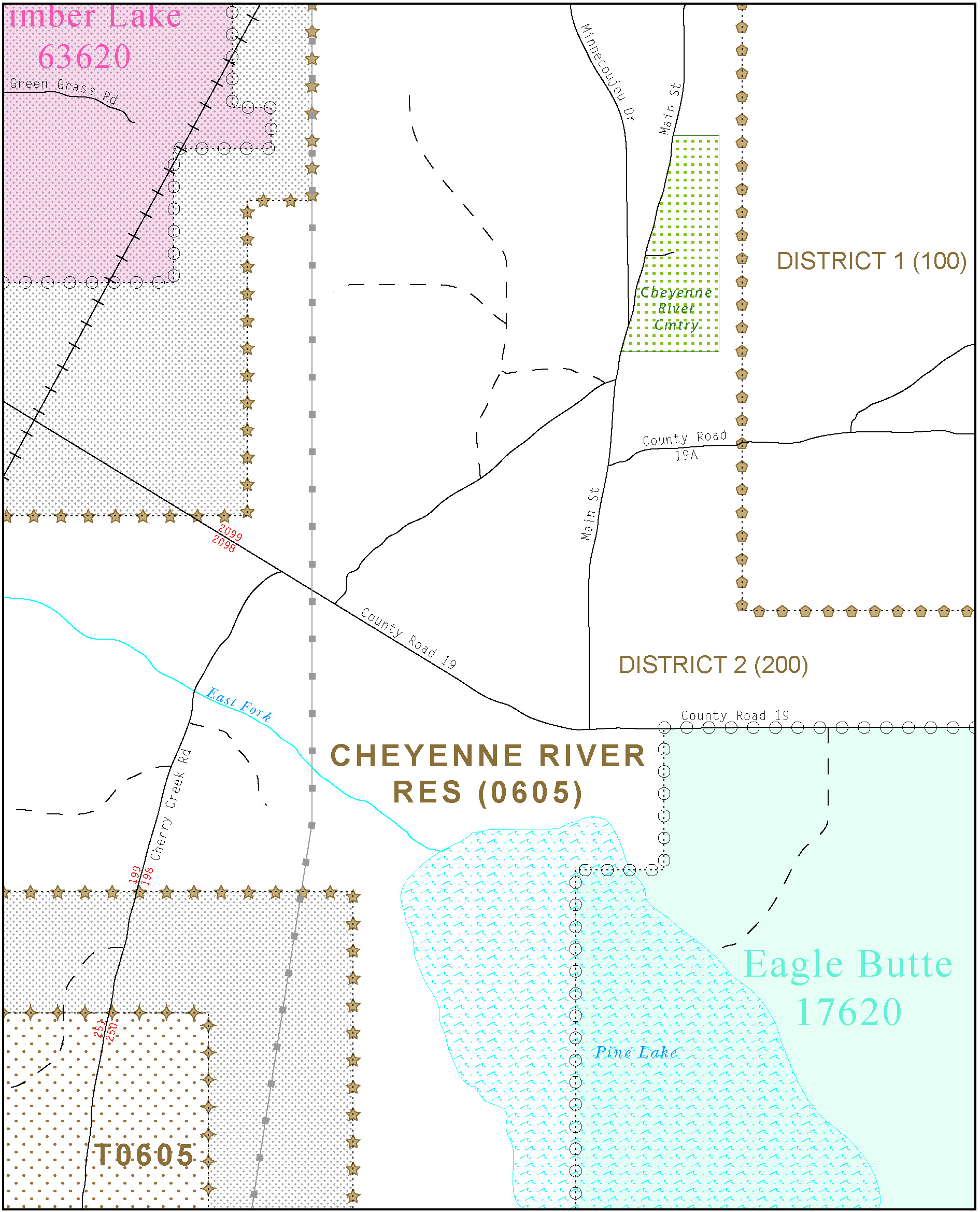
Table of Contents
2.0 Updating the BAS Materials 2
2.1 Reviewing and Updating Your Form 2
2.2 Making Changes and Corrections to Your Maps 3
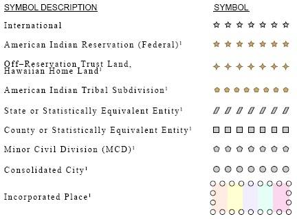
2.2.1 Explanation of map symbology 5
2.2.2 Boundary changes versus boundary corrections 6
2.2.4 Boundary with Coincident Feature Change 8
2.2.6 Tribal subdivision program procedures 10
2.2.7 Feature modifications 13
2.2.8 Inserting point and area features 14
2.2.9 Edits to street information 15
2.2.10 Adding feature names in a congested area 16
2.2.11 Correcting feature location 16
2.2.12 Correcting feature name 17
2.2.13 Annotating address breaks 18
2.2.15 Adding a cul-de-sac or circle 20
2.2.16 Designating a geographic corridor to a street feature 21
2.2.17 Designating a geographic offset to a street feature 22
3.0 Signing the Updated Maps 24
Appendix 1: Paperwork Reduction Project 26
Appendix 2: AIR Codes, Names and Census Bureau Regional Offices 27
Appendix 3: Census Bureau Regional Offices - Contact Information 35
1.0 Overview of the BAS
The Census Bureau conducts the Boundary and Annexation Survey (BAS) annually to collect boundary information about federally recognized American Indian reservations, including off-reservation trust lands and tribal subdivisions. The Census Bureau’s primary purpose for delineating tribal boundaries is to develop the best possible geographic framework for the tabulation and presentation of statistical information. For tribal governments with reservations or off-reservation trust lands, the Census Bureau developed the Tribal BAS to obtain and maintain the most current, legally established boundaries of reservations and off-reservation trust lands.
In support of the government-to-government relationship with federally recognized American Indian tribes, the Census Bureau works directly with tribal officials to maintain a current and comprehensive inventory of correct names, legal descriptions and legal boundaries for federally recognized tribes with reservations and/or off-reservation trust lands. Through the BAS, the Census Bureau updates reservation, off-reservation trust land and tribal subdivision boundaries, as well as their names and features (features such as roads or rivers), and address information at the boundaries. The information collected is used to tabulate data from various programs and surveys, such as the American Community Survey and 2010 Census. Maintaining these boundaries and boundary-to-feature relationships correctly through the BAS makes certain that the appropriate population is assigned to your area.
If there are changes to the boundary of your American Indian Area (AIA), the Census Bureau appreciates your cooperation in completing the BAS forms (offered in either paper or electronic form), marking changes on the maps, and returning the maps and forms to the Census Bureau by April 1.
If a tribal government disagrees with the Census Bureau’s depiction of their boundary and provides supporting documents that pre-date 1990 when our boundaries were last sanctioned by the BIA, we ask for clarification from the U.S. Department of the Interior, Office of the Solicitor regarding the correct current boundary. Often complicated legal land issues require an extended period of time for resolution, and in those cases, the Census Bureau retains the boundary we have in our database until a legal opinion is issued by the Solicitor’s office.
In compliance with the Office of Management and Budget Circular A-16, the BAS supports the Census Bureau’s spatial data steward responsibilities for the Federal Geographic Data Committee and the Geospatial One-Stop by updating the inventory of, and boundaries for, governmental units. In addition, the BAS is the source of up-to-date information on boundaries, codes, and names for the U.S. Geological Survey’s (USGS) National Map and the Geographic Names Information System.
2.0 Updating the BAS Materials
There are six steps involved in updating the BAS materials, including:
Reviewing and updating (if necessary) the geographic information on the form
Reviewing and annotating the map with boundary changes and corrections
Annotating feature changes, additions, or deletions on the map
Annotating the address breaks at the intersection of roads and boundaries
Signing the updated maps and forms
Returning the signed maps and forms
It is important that all questions on the form are answered completely. If there are no changes to report, please return only the “No Change” postcard provided with your materials. Please do not return all of the materials. If there are changes, sign and return only the maps with changes. Return the completed form(s) and updated map(s) within 15 days using the pre-addressed envelope or return label.
2.1 Reviewing and Updating Your Form
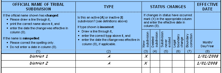
Begin with a review of all information printed on your form. If any information needs to be changed, cross out the incorrect data and print the correction beside it as shown in Example 2.1.1 below. Regarding misspelled names, cross out the error and print the correctly spelled name next to the misspelling. Provide an effective date for name, type or status changes. To correct the name of a federally recognized American Indian reservations, off-reservation trust land or tribal subdivision, follow the directions in Question 1 as follows:
Check “No”
Print the correct name and effective date of change
Continue with question 2
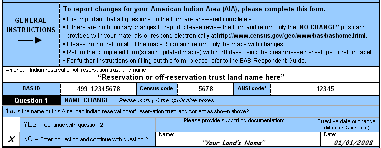
Example 2.1.1: Updating the tribal BAS-5 form and Question 1.
2.2 Making Changes and Corrections to Your Maps
This section includes general guidelines and detailed examples illustrating how to update boundary and feature information.
There are a number of general guidelines for changes and corrections to your maps:
Compare the BAS maps to a local source for your entity. Update the map(s) if the boundary shown does not correctly depict the boundary in effect as of January 1 of the survey year.
Refer to examples 2.2.2 through 2.2.5 on pages 6 through 9 for the differences between a boundary change and a boundary correction.
Address Information Update
The BAS maps show the last address stored in our geographic database for each street that crosses the boundary of your reservation. These addresses are shown because it is important that the Census Bureau assigns the correct addresses to each governmental unit. If you have reported an addition or deletion, or have corrected our depiction of your boundary, please provide us with the last address within the current boundary of your reservation.
Since the BAS only targets addresses at the boundary, the Census Bureau has other operations to collect address information. If you have a reliable source for addresses within your reservation, and would be willing to share that information with the Census Bureau, we request that you fill out the Address Source Information Worksheet that is included on the last page of this guide. The Census Bureau staff working on the BAS responses will forward the updated form to the address update staff with the information you provide about the source. The correct assignment of addresses is of primary importance to our censuses and surveys.
Although the BAS collects boundary information, the survey also accepts feature updates. Please refer to examples 2.2.7 through 2.2.15 on pages 13 through 20, and be sure to use the enclosed purple pencil for feature updates.
The Census Bureau is undertaking a nationwide program to improve the positional accuracy of all streets and other features that appear in the Census Bureau’s digital database. It is not necessary to make small positional corrections on the BAS maps; correct only those streets that are significantly mis-located, or new streets that are related to the location of a new boundary.
Do not make changes on the index map. Index maps are provided as a reference to help you quickly locate a map sheet. If you received only an index map for your reservation or trust land and you need to make boundary changes and/or feature updates, please call the phone number indicated on the BAS-5 form or e-mail geo.aiana@census.gov to request a full set of maps or the specific map sheet(s) needed.
The following examples are provided to illustrate how to update your boundary and feature information with the Census Bureau, including:
Explanation of map symbology
Boundary changes versus boundary corrections
Boundary changes
Boundary with coincident feature change
Boundary corrections
Tribal subdivision program procedures
Feature modifications
Inserting point and area features
Edits to street information
Adding feature names in a congested area
Correcting feature location
Correcting feature name
Annotating address breaks
Deleting a feature
Adding a cul-de-sac or circle
Designating a geographic corridor to the north and south of the street feature
Designating a geographic offset to the north of the street feature
Unnamed roads
2.2.1 Explanation of map symbology
This section provides examples of the BAS map symbology. You can review this symbology and BAS map legend online at the following Web site:
http://www.census.gov/geo/www/bas/bashome.html
The following example shows the different boundary symbols used on the BAS maps:
Example 2.2.1.1: Boundary symbology
In Example 2.2.1.2 below, Reservation Cheyenne River Reservation1 is the subject area. Trust lands are represented by a brown dot pattern. Incorporated places are represented by color fill and delineated by their respective boundary symbols. Note that all areas outside of the subject area are considered fringe areas. Fringe areas are shaded with a gray dot pattern.
Example 2.2.12: Reservation with incorporated place, tribal subdivision and trust land
2.2.2 Boundary changes versus boundary corrections
The two types of modifications that can be made to a boundary, are: boundary changes and boundary corrections. A boundary change is an alteration to a boundary as a result of a federal court decision, treaty, act of Congress, land taken into trust, etc. Reporting boundary changes is the primary goal of the BAS. A boundary correction is the minor adjustment of a boundary to correct a drafting error in how the Census Bureau depicts an existing boundary and does not require documentation.
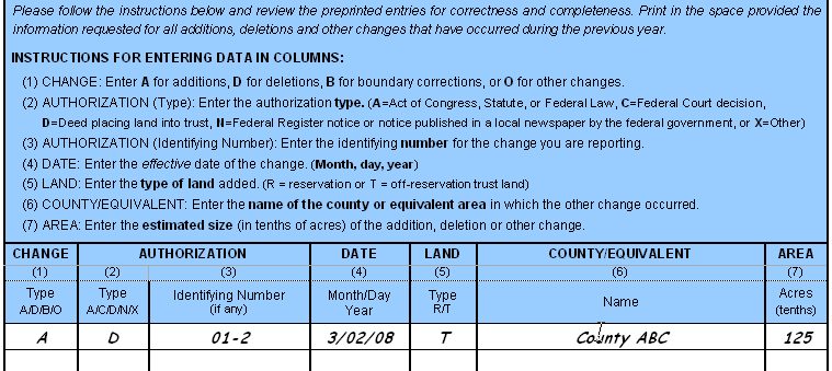
These figures illustrate how to make complete boundary changes, including additions or deletions, to your maps and BAS form. Using the red pencil provided, you will cross out the portion of the boundary that is no longer current with a string of “Xs”. Draw the new boundary line(s) ensuring that you close your boundary and do not leave an incomplete boundary as shown in the figures. Add the authorization number or other identifier of the action authorizing the change, along with the effective date of each addition or deletion that you draw on the map. Document these changes on the BAS form as shown below.
Complete Boundary Incomplete Boundary
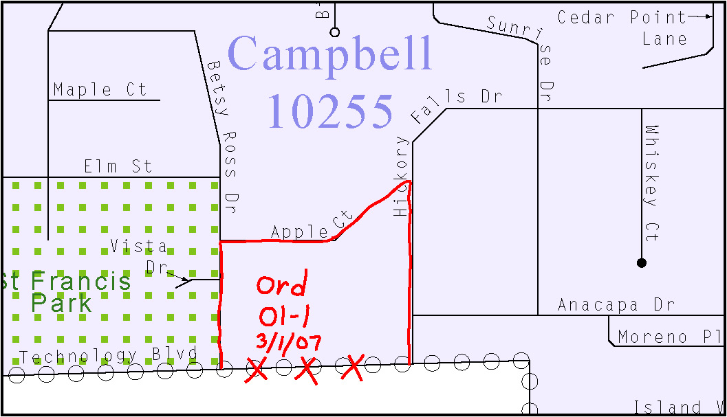
Example 2.2.3.1: The figure on the left illustrates how to make a complete boundary change. The figure on the right illustrates a common error with an incomplete boundary change.
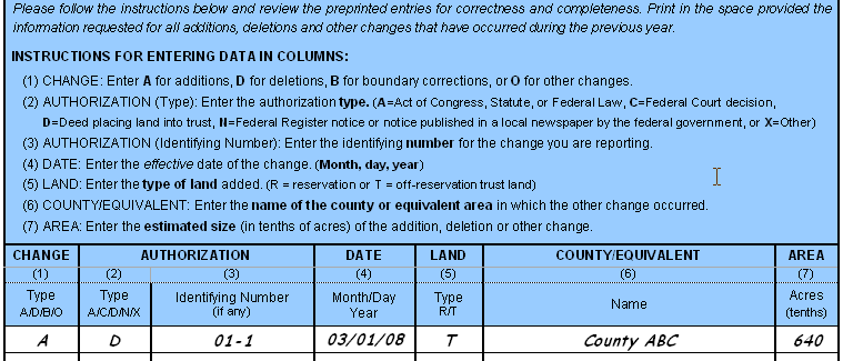
Example 2.2.3.2: Updating boundary changes on the tribal BAS form, BAS-5
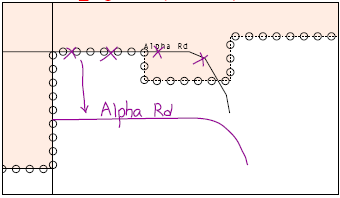
2.2.4 Boundary with coincident feature change
This figure illustrates how to make an adjustment to a boundary that is coincident with a feature, such as a street. Using the red pencil, cross out the portion of the boundary that is no longer current using a string of “Xs” inside circles. Add the authorization number or other identifier of the action authorizing the change along with the effective date of each addition or deletion. Document these changes on the tribal BAS form as shown in the following figures.
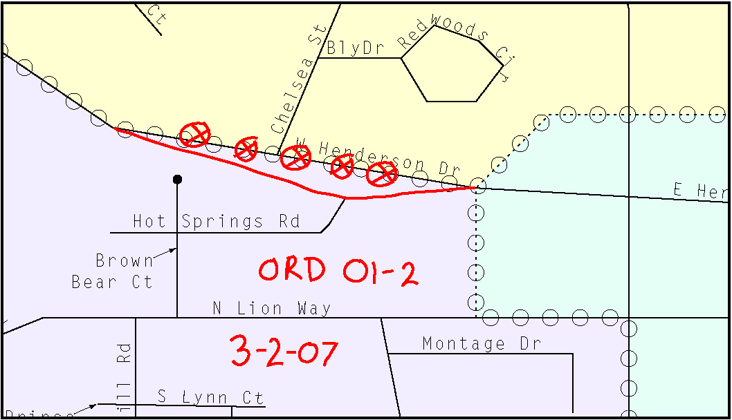
Example 2.2.4.1: Making a change to a boundary coincident with a road feature
Example 2.2.4.2: Updating the tribal BAS form for a change to a boundary coincident with a feature
This figure illustrates how to complete a boundary correction on the map and tribal BAS form. Boundary corrections do not require documentation, but we may need to contact you for additional information if the correction requires clarification.
Using the enclosed red pencil provided, you will cross out the incorrect boundaries with a string of “Xs”, add a line showing the correct boundary and print the letters “BC” as shown in the figure below, to identify the change as a boundary correction rather than a change. Document these changes on the tribal BAS form as shown in the following figures.
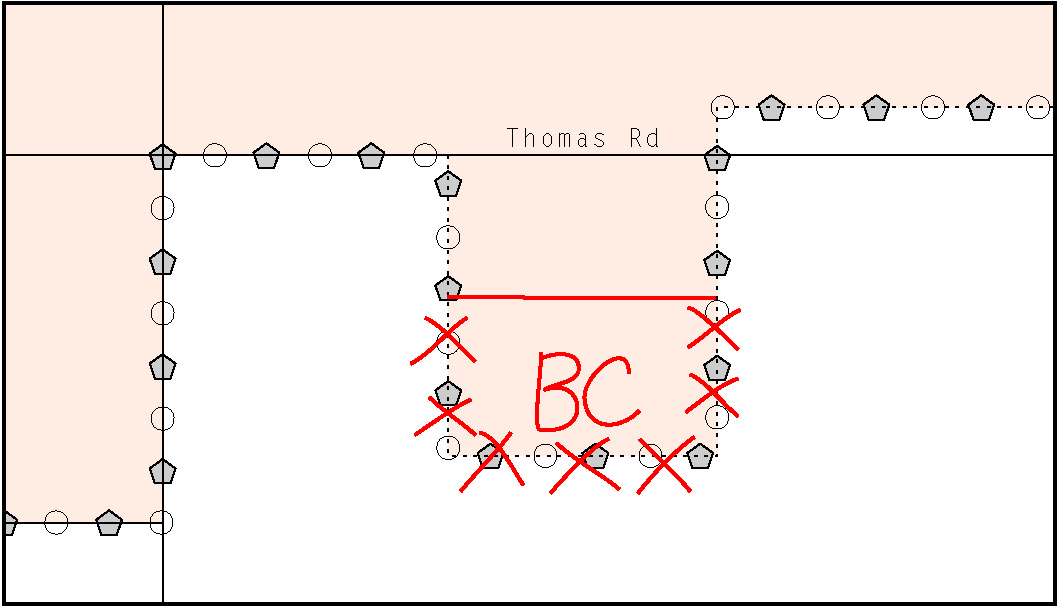
Example 2.2.5.1: Making a boundary correction
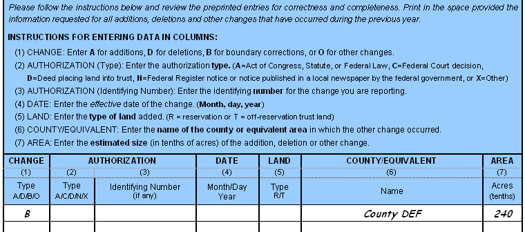
Example 2.2.5.2: Updating the tribal BAS form for a boundary correction
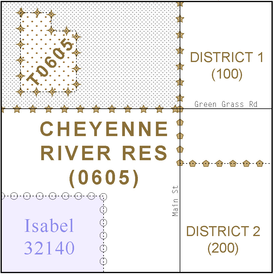
2.2.6 Tribal subdivision program procedures
Tribes may submit the boundaries for one type of administrative area within their reservation(s) and/or off-reservation trust lands (land base) for inclusion into the Census Bureau’s geographic database. The Census Bureau will consider any type of unit of self-government or administration as a “tribal subdivision.” Tribes that delineated tribal subdivisions during earlier BAS cycles have the opportunity to review and correct names, type and status of subdivisions in Question 5 on the BAS-5B form. Additionally, tribes should review the information shown on the maps and note any needed change or correction to their tribal subdivision’s boundaries. Tribal subdivisions should cover all, or most, of the tribe’s land base. If a tribe has more than one type of distinct administrative area that could qualify as a tribal subdivision (e.g., tribal election districts, tribal water districts, or health service areas with different boundaries), the tribe may submit only one type of subdivision. Tribal subdivisions can be considered either active (A) or inactive (I). Active subdivisions are defined as having a functioning government with elected officials that provides programs and services. Inactive subdivisions have no functioning government or elected officials and receive services solely from the tribe. Some examples of areas submitted as tribal subdivisions are:
Areas used by your tribe for the election of tribal government officials (e.g., districts or precincts used for the election of tribal council members);
Areas used by your tribal government for tax purposes;
Areas used by your tribal government for the provision of general services or specified services, such as:
water districts
health service areas
emergency service delivery areas (e.g., 911, fire, and/or police), or
grazing districts or range units
Historical or traditional areas recognized by your tribal government;
Local tribal community governments.
The Census Bureau requests that you add and/or revise your tribal subdivision boundaries on the BAS map(s) and complete the forms enclosed within this package. (If a full set of BAS maps has not been sent, please request them.) If your tribe delineated tribal subdivisions during a prior survey, tribal subdivision boundaries are symbolized on the enclosed BAS maps by a solid blue line. Before you add/or revise your tribal subdivision boundaries on the enclosed map(s), please note any changes to the boundary of your land base on the map(s) using the enclosed red pencil. Add and/or revise the boundaries of your tribal subdivisions on the enclosed BAS map(s) using the enclosed blue pencil. Additionally, the names and type (active or inactive) of your subdivisions are listed in Question 5 on the BAS-5B form. Please review and update this information.
If this is the first time you are providing tribal subdivisions, please add the boundaries on the BAS map(s) using the enclosed blue pencil. You must label each tribal subdivision on each map sheet with its name (e.g., “District 3,” “Arlee District,” “White Rock Chapter,” “Parmelee Community,” and so forth) and record the names, type, and status of each in Question 5 on the BAS-5B form. Examples of the tribal subdivisions include, but are not limited to: chapters, communities, districts, segments, and villages. Please note that tribal and tribal subdivision boundaries are not required to follow visible features (such as roads, rivers, or fence-lines). If you have any questions, please contact your Census Bureau Regional Office’s Geography staff at the telephone number shown on your enclosed BAS-5 form.
Criteria for Defining Tribal Subdivisions:
The delineation of tribal subdivisions is restricted to the area contained within your reservation(s) and/or associated off-reservation trust lands (land base).
There is no minimum population threshold for a tribal subdivision.
Tribal subdivisions should cover all, or most, of the tribe’s land base.
A tribal subdivision may be discontiguous.
Your tribe may designate only ONE type of tribal subdivision. If your tribe has more than one level of tribal subdivisions within its land base, the Census Bureau recommends delineating subdivisions corresponding to the lowest geographic level (i.e., those geographic areas containing the smallest area) of the tribe’s administrative hierarchy.
Tribal subdivisions should not be based solely on land ownership or other cadastral areas, nor should they consist of divisions based on the U.S. public land survey system of townships, ranges, and sections, if these areas have no governmental or administrative function for your tribe.
If you have any questions or need to order maps, please contact your Regional Office’s Geography staff at the telephone number shown on your enclosed BAS-5 form.
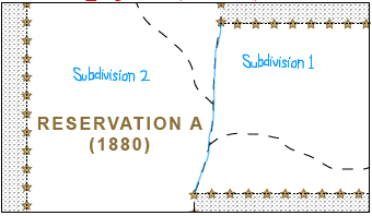
Example 2.2.6: Depicting a tribal subdivision
Example 2.2.6: Recording a tribal subdivision on the tribal BAS form
This figure illustrates how to make feature modifications that may or may not be coincident with a boundary. Using the purple pencil, you will cross out the incorrect feature location with “Xs”. Draw the feature in the correct location, and print the name of the feature as shown in the figure below.
Example 2.2.7: Making a feature modification to a road that is partially coincident with a boundary
Note that adding features internal to the boundary of your reservation or off-reservation trust land is not required as part of the BAS. This is also true for other features such as streams, point features or areal features. If you choose to provide these, please see section 2.2.7 (above) through section 2.2.11.
2.2.8 Inserting point and area features
This figure illustrates how to insert point and/or area features, including mountains and airports. Using the purple pencil, draw the feature in the correct location, and print the name of the feature as shown in the figure below.
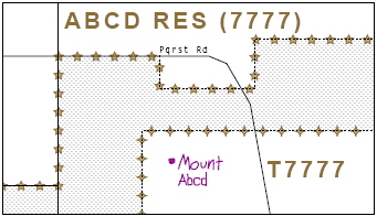
Example 2.2.8.1: Adding a mountain, point feature
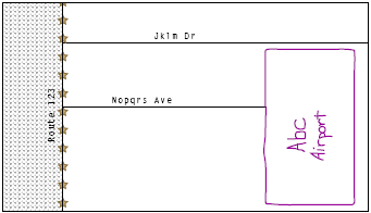
Example 2.2.8.2: Adding an airport, area feature
2.2.9 Edits to street information
This figure illustrates how to add missing streets, new streets, alternate street names and address information.
When adding a missing street, new street, or other feature on the map, use the purple pencil to draw the feature and its name on the map, as shown in the figure below.
If you know an alternate street name, print the alternate in parentheses as shown in the following figure.
Provide the lowest or highest addresses that could be assigned to a road where the road intersects a boundary as shown in the following figure.
If the street has addresses, please provide the name of a source for those addresses on the Address Source Information Worksheet included on the last page of this guide.
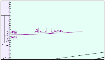
Example 2.2.9: Adding a road feature with annotation, address breaks and an alternate road name
2.2.10 Adding feature names in a congested area
This figure illustrates how to add feature names to a congested area on the map. Using the purple pencil, draw the features onto the map. If the area is too congested to add all feature names on the map provided, number each feature and list this number and the corresponding feature name in the map margin or an uncongested spot close to the feature’s actual location as shown in the following figure. Please do not repeat numbers on a map sheet.
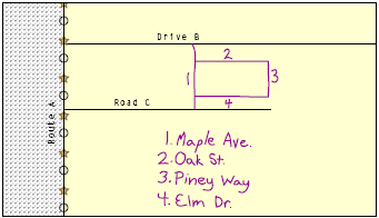
Example 2.2.10: Adding street name features in a congested area
2.2.11 Correcting feature location
This figure illustrates how to correct a feature location.
Using the purple pencil, cross out the existing feature on the map, and draw the feature in the correct location. Draw an arrow pointing to the correct feature location. Label the feature with the feature’s name.
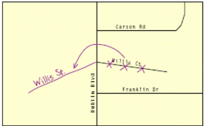
Example 2.2.11: Correcting the location of a street feature
2.2.12 Correcting feature name
This figure illustrates how to correct a feature name. Using the purple pencil, draw a line through the incorrect feature name. Print the correct feature name next to the original name as shown in the following figure.
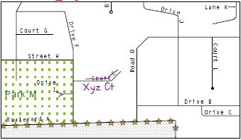
Example 2.2.12: Correcting a street feature name
2.2.13 Annotating address range breaks
The BAS maps show the last address stored in our geographic database for each street that crosses the boundary of your reservation. These addresses are shown because it is important that the Census Bureau assigns the correct addresses to each governmental unit. Since the BAS only targets addresses at the boundary, the Census Bureau has other operations that are designed to collect address information.2
If any of the following circumstances exist, use the purple pencil to add the last address along a street where it intersects the current boundary:
Addition or deletion was reported
Our depiction of your boundary was corrected
A street was added that crossed a boundary
Our depiction of the address is incorrect
Example 2.2.13: Adding a street feature and annotating with the name and address breaks
This figure illustrates how to delete a feature. Delete only if a feature is nonexistent or if a street is impassable. Do not delete a street because your government is not responsible for maintaining it.
Mark the beginning and end of the base feature to be deleted with hatch (//) marks perpendicular to the feature as shown below. Cross out what is to be removed using a string of “Xs”.
Example 2.2.14: Deleting a street feature
2.2.15 Adding a cul-de-sac or circle
This figure shows how to correctly represent a cul-de-sac or circle with illustrations of each symbol and corresponding aerial photographs. The photographs are provided to show the difference between cul-de-sacs and circles. A cul-de-sac is paved, whereas, a circle has an area of unpaved ground within it.
To add a cul-de-sac or circle, draw the feature using the purple pencil following one of the sketches below. Print the name of the associated street leading to the cul-de-sac or circle.
Example 2.2.15: Adding cul-de-sac and circle features with annotations
2.2.16 Designating a geographic corridor to a street feature
This figure illustrates how to display a geographic corridor (a corridor that occurs on both sides of a road).
A geographic corridor is an area that only includes road surface and right-of-way and does not contain any structures addressed to either side of the road. The Census Bureau geocodes addresses based upon the centerline. There are two types of geographic corridors:
An area where only the road, or other feature, belongs to your reservation or off-reservation trust land
An area where a road, or other feature is not part of your reservation or off-reservation trust land
To indicate a geographic corridor on your map, use the red pencil to draw a line on each side of the road. Mark the beginning and end of each line with perpendicular hatch marks. Write the letters “GC” beside each line.
Example 2.2.16: Designating a geographic corridor to the north and south of the street feature
2.2.17 Designating a geographic offset to a street feature
This figure illustrates how to display a geographic offset (a corridor on one side of the road).
A geographic offset is an area claimed by an entity that is only on one side of the road and does not include any structures addressed to that side of the road. The Census Bureau geocodes addresses based on the centerline of roads. If your boundary is not coincident with the centerline but follows the parcel line, and the addresses along the road should be in your jurisdiction, you need to report a geographic offset. By coding the offset the addresses will be assigned to the correct geography.
To indicate a geographic offset on your map, use the red pencil to draw a line parallel to the road on the side where the offset exists. At the beginning and end of the offset draw double hatch marks. Write the word “Off” near to the line.
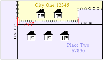
Example 2.2.17: Identifying a geographic offset to the north of the street feature
If you find unnamed road segments on the maps, please provide the road names, if known, using the purple pencil or label them as “PR” if these are unnamed private roads. Examples of private roads are driveways and unnamed roads in commercial or industrial parks.
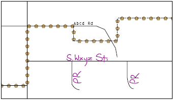
Example 2.2.18: Adding unnamed road features with annotation
For each map sheet that has changes, fill in the Signature Box on one copy of the map:
Print the date, your name, position and phone number
Sign your name
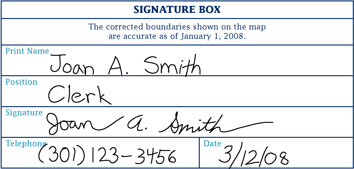
Example 3.0: Completing the signature box on the map sheet
Use the postage-paid envelope to return the set of signed tribal maps and the BAS form to the Census Bureau. If after reviewing the tribal BAS forms and maps it is determined that you do not have any changes to report, sign the “No Change” postcard and return it to the Census Bureau.
Appendices
Appendix 1: Paperwork Reduction Project
The Census Bureau estimates that the BAS review will take most respondents from 1 to 6 hours to complete. This includes the time needed to read the instructions, assemble materials, organize and review the information, and report any needed changes. This estimate is based on 80 percent of all areas having few or no changes. However, for areas with many changes it may take 20 hours or longer to complete the survey. Please send comments regarding this burden estimate or any other aspect of this collection of information, including suggestions for reducing this burden to:
Paperwork Project 0607-0151
U.S. Census Bureau
4600 Silver Hill Road
Room 3K138
Washington, DC 20233
Or you may e-mail comments to:
paperwork@census.gov
Note: use “Paperwork Project 0607-0151” as the subject.
Please include a copy of your message addressed to:
geo.bas@census.gov
Appendix 2: AIR Codes, Names and Census Bureau Regional Offices
American Indian Areas / Census Bureau Regional Offices |
||
AIR Code |
AIR Name |
RO/RCC |
49900002250 |
Big Cypress Reservation |
Atlanta |
49900003600 |
Brighton Reservation |
Atlanta |
49900006900 |
Coconut Creek Reservation |
Atlanta |
49900012600 |
Fort Pierce Reservation |
Atlanta |
49900014750 |
Hollywood Reservation |
Atlanta |
49900015550 |
Immokalee Reservation |
Atlanta |
49900022400 |
Miccosukee Reservation |
Atlanta |
49900028650 |
Poarch Creek Reservation and Off-Reservation Trust Land |
Atlanta |
49900036650 |
Seminole (FL) Trust Land |
Atlanta |
49900041300 |
Tampa Reservation |
Atlanta |
49900000800 |
Allegany Reservation |
Boston |
49900005400 |
Cattaraugus Reservation |
Boston |
49900015300 |
Houlton Maliseet Trust Land |
Boston |
49900015750 |
Indian Township Reservation |
Boston |
49900021450 |
Mashantucket Pequot Reservation |
Boston |
49900023200 |
Mohegan Reservation |
Boston |
49900024150 |
Narragansett Reservation |
Boston |
49900025350 |
Oil Springs Reservation |
Boston |
49900025550 |
Oneida Nation Reservation |
Boston |
49900025700 |
Onondaga Nation Reservation |
Boston |
49900026950 |
Passamaquoddy Trust Land |
Boston |
49900027600 |
Penobscot Reservation and Off-Reservation Trust Land |
Boston |
49900028500 |
Pleasant Point Reservation |
Boston |
49900033200 |
St. Regis Mohawk Reservation |
Boston |
49900042250 |
Tonawanda Reservation |
Boston |
49900043600 |
Tuscarora Nation Reservation |
Boston |
49900045300 |
Wampanoag-Aquinnah Trust Land |
Boston |
49900005250 |
Catawba Reservation |
Charlotte |
49900009900 |
Eastern Cherokee Reservation |
Charlotte |
49900001400 |
Bad River Reservation |
Chicago |
49900011350 |
Forest County Potawatomi Community and Off-Reservation Trust Land |
Chicago |
49900014500 |
Ho-Chunk Nation Reservation and Off-Reservation Trust Land |
Chicago |
49900018150 |
Lac Courte Oreilles Reservation and Off-Reservation Trust Land |
Chicago |
49900018250 |
Lac du Flambeau Reservation |
Chicago |
49900021750 |
Menominee Reservation |
Chicago |
49900025600 |
Oneida (WI) Reservation and Off-Reservation Trust Land |
Chicago |
49900030850 |
Red Cliff Reservation and Off-Reservation Trust Land |
Chicago |
49900033050 |
St. Croix Reservation and Off-Reservation Trust Land |
Chicago |
49900038850 |
Sokaogon Chippewa Community |
Chicago |
49900040150 |
Stockbridge Munsee Community |
Chicago |
49900049150 |
Menominee/Stockbridge-Munsee joint use area |
Chicago |
49900000500 |
Alabama-Coushatta Reservation |
Dallas |
49900006350 |
Chitimacha Reservation |
Dallas |
49900007950 |
Coushatta Reservation |
Dallas |
49900017750 |
Kickapoo (TX) Reservation |
Dallas |
49900023000 |
Mississippi Choctaw Reservation |
Dallas |
49900043150 |
Tunica-Biloxi Reservation |
Dallas |
49900047550 |
Ysleta Del Sur Pueblo and Off-Reservation Trust Land |
Dallas |
49900000100 |
Acoma Pueblo and Off-Reservation Trust Land |
Denver |
49900001650 |
Battle Mountain Reservation |
Denver |
49900003050 |
Blackfeet Indian Reservation and Off-Reservation Trust Land |
Denver |
49900004400 |
Campbell Ranch |
Denver |
49900005100 |
Carson Colony |
Denver |
49900006050 |
Cheyenne River Sioux Indian Reservation and Off-Reservation Trust Land |
Denver |
49900006800 |
Cochiti Pueblo |
Denver |
49900006950 |
Cocopah Reservation |
Denver |
49900007350 |
Colorado River Indian Reservation |
Denver |
49900008450 |
Crow Reservation and Off-Reservation Trust Land |
Denver |
49900008550 |
Crow Creek Reservation |
Denver |
49900009400 |
Dresslerville Colony |
Denver |
49900009650 |
Duck Valley Reservation |
Denver |
49900009750 |
Duckwater Reservation |
Denver |
49900010050 |
Elko Colony |
Denver |
49900010400 |
Ely Reservation |
Denver |
49900010700 |
Fallon Paiute-Shoshone Colony and Off-Reservation Trust Land |
Denver |
49900010750 |
Fallon Paiute-Shoshone Reservation and Off-Reservation Trust Land |
Denver |
49900011000 |
Flandreau Reservation |
Denver |
49900011100 |
Flathead Reservation |
Denver |
49900011400 |
Fort Apache Reservation |
Denver |
49900011500 |
Fort Belknap Reservation and Off-Reservation Trust Land |
Denver |
49900011600 |
Fort Berthold Reservation |
Denver |
49900012100 |
Fort McDermitt Indian Reservation |
Denver |
49900012200 |
Fort McDowell Yavapai Nation Reservation |
Denver |
49900012350 |
Fort Mojave Reservation and Off-Reservation Trust Land |
Denver |
49900012500 |
Fort Peck Indian Reservation and Off-Reservation Trust Land |
Denver |
49900013100 |
Gila River Indian Reservation |
Denver |
49900013400 |
Goshute Reservation |
Denver |
49900014400 |
Havasupai Reservation |
Denver |
49900015050 |
Hopi Reservation and Off-Reservation Trust Land |
Denver |
49900015450 |
Hualapai Indian Reservation and Off-Reservation Trust Land |
Denver |
49900016250 |
Isleta Pueblo |
Denver |
49900016850 |
Jemez Pueblo |
Denver |
49900017000 |
Jicarilla Apache Nation Reservation |
Denver |
49900017200 |
Kaibab Indian Reservation |
Denver |
49900018400 |
Laguna Pueblo and Off-Reservation Trust Land |
Denver |
49900018600 |
Lake Traverse Reservation and Off-Reservation Trust Land |
Denver |
49900019150 |
Las Vegas Indian Colony |
Denver |
49900020150 |
Lovelock Indian Colony |
Denver |
49900020300 |
Lower Brule Reservation and Off-Reservation Trust Land |
Denver |
49900021300 |
Maricopa (Ak Chin) Indian Reservation |
Denver |
49900022050 |
Mescalero Reservation |
Denver |
49900023150 |
Moapa River Indian Reservation |
Denver |
49900024000 |
Nambe Pueblo and Off-Reservation Trust Land |
Denver |
49900024300 |
Navajo Nation Reservation and Off-Reservation Trust Land |
Denver |
49900024900 |
Northern Cheyenne Indian Reservation and Off-Reservation Trust Land |
Denver |
49900025050 |
Northwestern Shoshoni Reservation |
Denver |
4990002510 |
Ohkay Owingeh |
Denver |
49900025500 |
Omaha Reservation |
Denver |
49900026250 |
Paiute (UT) Reservation |
Denver |
49900026800 |
Pascua Pueblo Yaqui Reservation |
Denver |
49900027850 |
Picuris Pueblo |
Denver |
49900028100 |
Pine Ridge Reservation and Off-Reservation Trust Land |
Denver |
49900029000 |
Ponca (NE) Trust Land |
Denver |
4990002990 |
Pueblo of Pojoaque |
Denver |
49900030100 |
Pyramid Lake Reservation |
Denver |
49900031300 |
Reno-Sparks Indian Colony |
Denver |
49900032050 |
Rocky Boy's Reservation and Off-Reservation Trust Land |
Denver |
49900032350 |
Rosebud Indian Reservation and Off-Reservation Trust Land |
Denver |
49900033400 |
Salt River Reservation |
Denver |
49900033550 |
San Carlos Reservation |
Denver |
49900033700 |
Sandia Pueblo |
Denver |
49900034000 |
San Felipe Pueblo |
Denver |
49900034150 |
San Ildefonso Pueblo and Off-Reservation Trust Land |
Denver |
49900034800 |
Santa Ana Pueblo |
Denver |
49900034950 |
Santa Clara Pueblo |
Denver |
49900035650 |
Santee Reservation |
Denver |
49900035850 |
Santo Domingo Pueblo |
Denver |
49900038400 |
Skull Valley Reservation |
Denver |
49900039250 |
Southern Ute Reservation |
Denver |
49900039300 |
South Fork Reservation and Off-Reservation Trust Land |
Denver |
49900039350 |
Spirit Lake Reservation |
Denver |
49900039700 |
Standing Rock Reservation |
Denver |
49900039800 |
Stewart Community |
Denver |
49900040450 |
Summit Lake Reservation |
Denver |
49900041400 |
Taos Pueblo and Off-Reservation Trust Land |
Denver |
49900041700 |
Tesuque Pueblo and Off-Reservation Trust Land |
Denver |
49900042000 |
Tohono O'odham Nation Reservation and Off-Reservation Trust Land |
Denver |
49900042350 |
Tonto Apache Reservation |
Denver |
49900043450 |
Turtle Mountain Reservation and Off-Reservation Trust Land |
Denver |
49900043900 |
Uintah and Ouray Reservation and Off-Reservation Trust Land |
Denver |
49900044700 |
Ute Mountain Reservation and Off-Reservation Trust Land |
Denver |
49900045150 |
Walker River Reservation |
Denver |
49900045600 |
Washoe Trust Land |
Denver |
49900045800 |
Wells Colony |
Denver |
49900046100 |
Wind River Reservation and Off-Reservation Trust Land |
Denver |
49900046250 |
Winnebago Reservation and Off-Reservation Trust Land |
Denver |
49900046350 |
Winnemucca Indian Colony |
Denver |
49900046650 |
Woodfords Community |
Denver |
49900047000 |
Yankton Reservation |
Denver |
49900047080 |
Yavapai-Apache Nation Reservation |
Denver |
49900047100 |
Yavapai-Prescott Reservation |
Denver |
49900047250 |
Yerington Colony |
Denver |
49900047400 |
Yomba Reservation |
Denver |
49900047700 |
Zia Pueblo and Off-Reservation Trust Land |
Denver |
49900047850 |
Zuni Reservation and Off-Reservation Trust Land |
Denver |
49900049300 |
San Felipe/Santa Ana joint use area |
Denver |
49900049400 |
San Felipe/Santo Domingo joint use area |
Denver |
49900001700 |
Bay Mills Reservation and Off-Reservation Trust Land |
Detroit |
49900013700 |
Grand Traverse Reservation and Off-Reservation Trust Land |
Detroit |
49900014100 |
Hannahville Indian Community and Off-Reservation Trust Land |
Detroit |
49900015500 |
Huron Potawatomi Reservation |
Detroit |
49900016100 |
Isabella Reservation |
Detroit |
49900018300 |
Lac Vieux Desert Reservation |
Detroit |
49900018800 |
L'Anse Reservation and Off-Reservation Trust Land |
Detroit |
49900019600 |
Little River Reservation |
Detroit |
49900019630 |
Little Traverse Bay Reservation |
Detroit |
4990002890 |
Pokagon Reservation |
Detroit |
49900025800 |
Ontonagon Reservation |
Detroit |
49900036350 |
Sault Ste. Marie Reservation and Off-Reservation Trust Land |
Detroit |
49900003350 |
Bois Forte Reservation |
Kansas City |
49900011250 |
Fond du Lac Reservation and Off-Reservation Trust Land |
Kansas City |
49900013550 |
Grand Portage Reservation and Off-Reservation Trust Land |
Kansas City |
49900015900 |
Iowa (KS-NE) Reservation and Off-Reservation Trust Land |
Kansas City |
49900017700 |
Kickapoo (KS) Reservation |
Kansas City |
49900019400 |
Leech Lake Reservation and Off-Reservation Trust Land |
Kansas City |
49900020550 |
Lower Sioux Indian Community |
Kansas City |
49900022700 |
Mille Lacs Reservation and Off-Reservation Trust Land |
Kansas City |
49900022850 |
Minnesota Chippewa Trust Land |
Kansas City |
49900025950 |
Osage Reservation |
Kansas City |
49900029800 |
Prairie Band of Potawatomi Nation Reservation |
Kansas City |
49900029850 |
Prairie Island Indian Community and Off-Reservation Trust Land |
Kansas City |
49900031000 |
Red Lake Reservation |
Kansas City |
49900032800 |
Sac and Fox/Meskwaki Settlement |
Kansas City |
49900032850 |
Sac and Fox Nation (KS-NE) Reservation and Off-Reservation Trust Land |
Kansas City |
49900033850 |
Sandy Lake Reservation |
Kansas City |
49900036800 |
Shakopee Mdewakanton Sioux Community and Off-Reservation Trust Land |
Kansas City |
49900044450 |
Upper Sioux Community |
Kansas City |
49900045950 |
White Earth Reservation and Off-Reservation Trust Land |
Kansas City |
49900049100 |
Kickapoo (KS)/Sac and Fox Nation (KS-NE) joint use area |
Kansas City |
49900000200 |
Agua Caliente Indian Reservation |
Los Angeles |
49900001250 |
Augustine Reservation |
Los Angeles |
49900001550 |
Barona Reservation |
Los Angeles |
49900002500 |
Big Pine Reservation |
Los Angeles |
49900002650 |
Big Sandy Rancheria |
Los Angeles |
49900002900 |
Bishop Reservation |
Los Angeles |
49900004150 |
Cabazon Reservation |
Los Angeles |
49900004350 |
Cahuilla Reservation |
Los Angeles |
49900004500 |
Campo Indian Reservation |
Los Angeles |
49900004950 |
Capitan Grande Reservation |
Los Angeles |
49900005850 |
Chemehuevi Reservation |
Los Angeles |
49900007200 |
Cold Springs Rancheria |
Los Angeles |
49900008700 |
Cuyapaipe Reservation |
Los Angeles |
49900011950 |
Fort Independence Reservation |
Los Angeles |
49900012800 |
Fort Yuma Indian Reservation |
Los Angeles |
49900015600 |
Inaja and Cosmit Reservation |
Los Angeles |
49900016700 |
Jamul Indian Village |
Los Angeles |
49900018500 |
La Jolla Reservation |
Los Angeles |
49900018950 |
La Posta Indian Reservation |
Los Angeles |
49900019700 |
Lone Pine Reservation |
Los Angeles |
49900019950 |
Los Coyotes Reservation |
Los Angeles |
49900021150 |
Manzanita Reservation |
Los Angeles |
49900021900 |
Mesa Grande Reservation |
Los Angeles |
49900023600 |
Morongo Reservation |
Los Angeles |
49900024950 |
North Fork Rancheria |
Los Angeles |
49900026350 |
Pala Reservation |
Los Angeles |
49900027150 |
Pauma and Yuima Reservation |
Los Angeles |
49900027450 |
Pechanga Reservation |
Los Angeles |
49900027750 |
Picayune Rancheria |
Los Angeles |
49900030700 |
Ramona Village |
Los Angeles |
49900031650 |
Rincon Reservation |
Los Angeles |
49900034450 |
San Manuel Reservation |
Los Angeles |
49900034600 |
San Pasqual Reservation |
Los Angeles |
49900035200 |
Santa Rosa Rancheria |
Los Angeles |
49900035250 |
Santa Rosa Reservation |
Los Angeles |
49900035400 |
Santa Ynez Reservation |
Los Angeles |
49900035500 |
Santa Ysabel Reservation |
Los Angeles |
49900038700 |
Soboba Reservation |
Los Angeles |
49900040900 |
Sycuan Reservation |
Los Angeles |
49900041100 |
Table Mountain Rancheria |
Los Angeles |
49900041800 |
Timbi-Sha Shoshone Reservation and Off-Reservation Trust Land |
Los Angeles |
49900042550 |
Torres-Martinez Reservation |
Los Angeles |
49900043000 |
Tule River Reservation |
Los Angeles |
49900043750 |
Twenty-Nine Palms Reservation |
Los Angeles |
49900045000 |
Viejas Reservation |
Los Angeles |
49900000950 |
Alturas Indian Rancheria |
Seattle |
49900001100 |
Annette Island Reserve |
Seattle |
49900001200 |
Auburn Rancheria |
Seattle |
49900001850 |
Benton Paiute Reservation |
Seattle |
49900002000 |
Berry Creek Rancheria and Off-Reservation Trust Land |
Seattle |
49900002150 |
Big Bend Rancheria |
Seattle |
49900002400 |
Big Lagoon Rancheria |
Seattle |
49900002750 |
Big Valley Rancheria |
Seattle |
49900003250 |
Blue Lake Rancheria |
Seattle |
49900003500 |
Bridgeport Reservation |
Seattle |
49900004000 |
Burns Paiute Indian Colony and Off-Reservation Trust Land |
Seattle |
49900005550 |
Cedarville Rancheria and Off-Reservation Trust Land |
Seattle |
49900005600 |
Celilo Village |
Seattle |
49900005750 |
Chehalis Reservation |
Seattle |
49900006200 |
Chicken Ranch Rancheria |
Seattle |
49900007050 |
Coeur d'Alene Reservation |
Seattle |
49900007500 |
Colusa Rancheria |
Seattle |
49900007600 |
Colville Reservation and Off-Reservation Trust Land |
Seattle |
49900007700 |
Coos, Lower Umpqua, and Siuslaw Reservation and Off-Reservation Trust Land |
Seattle |
49900007750 |
Coquille Reservation and Off-Reservation Trust Land |
Seattle |
49900007800 |
Cortina Indian Rancheria |
Seattle |
49900008150 |
Cow Creek Reservation |
Seattle |
49900008250 |
Coyote Valley Reservation |
Seattle |
49900009550 |
Dry Creek Rancheria |
Seattle |
49900010100 |
Elk Valley Rancheria |
Seattle |
49900010550 |
Enterprise Rancheria |
Seattle |
49900011700 |
Fort Bidwell Reservation |
Seattle |
49900011850 |
Fort Hall Reservation and Off-Reservation Trust Land |
Seattle |
49900013650 |
Grand Ronde Community |
Seattle |
49900013800 |
Greenville Rancheria |
Seattle |
49900013950 |
Grindstone Indian Rancheria |
Seattle |
49900014000 |
Guidiville Rancheria and Off-Reservation Trust Land |
Seattle |
49900014600 |
Hoh Indian Reservation |
Seattle |
49900014900 |
Hoopa Valley Reservation |
Seattle |
49900015150 |
Hopland Rancheria and Off-Reservation Trust Land |
Seattle |
49900016400 |
Jackson Rancheria |
Seattle |
49900016550 |
Jamestown S'Klallam Reservation and Off-Reservation Trust Land |
Seattle |
49900017350 |
Kalispel Reservation and Off-Reservation Trust Land |
Seattle |
49900017500 |
Karuk Reservation and Off-Reservation Trust Land |
Seattle |
49900017850 |
Klamath Reservation |
Seattle |
49900018000 |
Kootenai Reservation |
Seattle |
49900019250 |
Laytonville Rancheria |
Seattle |
49900019550 |
Likely Rancheria |
Seattle |
49900019800 |
Lookout Rancheria |
Seattle |
49900020400 |
Lower Elwha Reservation and Off-Reservation Trust Land |
Seattle |
49900020700 |
Lummi Reservation |
Seattle |
49900020750 |
Lytton Rancheria |
Seattle |
49900020850 |
Makah Indian Reservation |
Seattle |
49900021000 |
Manchester-Point Arena Rancheria |
Seattle |
49900022550 |
Middletown Rancheria |
Seattle |
49900023300 |
Montgomery Creek Rancheria |
Seattle |
49900023400 |
Mooretown Rancheria |
Seattle |
49900023750 |
Muckleshoot Reservation and Off-Reservation Trust Land |
Seattle |
49900024450 |
Nez Perce Reservation |
Seattle |
49900024600 |
Nisqually Reservation |
Seattle |
49900024750 |
Nooksack Reservation and Off-Reservation Trust Land |
Seattle |
49900026850 |
Pakenta Rancheria |
Seattle |
49900028200 |
Pinoleville Rancheria |
Seattle |
49900028350 |
Pit River Trust Land |
Seattle |
49900029100 |
Port Gamble Reservation |
Seattle |
49900029250 |
Port Madison Reservation |
Seattle |
49900030000 |
Puyallup Reservation and Off-Reservation Trust Land |
Seattle |
49900030200 |
Quartz Valley Reservation |
Seattle |
49900030300 |
Quileute Reservation |
Seattle |
49900030400 |
Quinault Reservation |
Seattle |
49900030950 |
Redding Rancheria |
Seattle |
49900031150 |
Redwood Valley Rancheria Reservation |
Seattle |
49900031450 |
Resighini Rancheria |
Seattle |
49900031850 |
Roaring Creek Rancheria |
Seattle |
49900031950 |
Robinson Rancheria and Off-Reservation Trust Land |
Seattle |
49900032200 |
Rohnerville Rancheria |
Seattle |
49900032500 |
Round Valley Reservation and Off-Reservation Trust Land |
Seattle |
49900032650 |
Rumsey Indian Rancheria |
Seattle |
49900036250 |
Sauk-Suiattle Reservation |
Seattle |
49900037350 |
Sherwood Valley Rancheria |
Seattle |
49900037500 |
Shingle Springs Rancheria |
Seattle |
49900037800 |
Shoalwater Bay Indian Reservation and Off-Reservation Trust Land |
Seattle |
49900037950 |
Siletz Reservation and Off-Reservation Trust Land |
Seattle |
49900038250 |
Skokomish Reservation |
Seattle |
49900038550 |
Smith River Rancheria and Off-Reservation Trust Land |
Seattle |
49900038600 |
Snoqualmie Reservation |
Seattle |
49900039400 |
Spokane Reservation |
Seattle |
49900039550 |
Squaxin Island Reservation and Off-Reservation Trust Land |
Seattle |
49900039850 |
Stewarts Point Rancheria |
Seattle |
49900040000 |
Stillaguamish Reservation |
Seattle |
49900040300 |
Sulphur Bank Rancheria |
Seattle |
49900040600 |
Susanville Indian Rancheria and Off-Reservation Trust Land |
Seattle |
49900040750 |
Swinomish Reservation |
Seattle |
49900040950 |
Table Bluff Reservation |
Seattle |
49900042750 |
Trinidad Rancheria and Off-Reservation Trust Land |
Seattle |
49900042900 |
Tulalip Reservation |
Seattle |
49900043300 |
Tuolumne Rancheria |
Seattle |
49900044050 |
Umatilla Reservation |
Seattle |
49900044300 |
Upper Lake Rancheria |
Seattle |
49900044550 |
Upper Skagit Reservation |
Seattle |
49900045450 |
Warm Springs Reservation and Off-Reservation Trust Land |
Seattle |
49900046800 |
XL Ranch |
Seattle |
49900046900 |
Yakama Nation Reservation and Off-Reservation Trust Land |
Seattle |
49900047600 |
Yurok Reservation |
Seattle |
Appendix 3: Census Bureau Regional Offices - Contact Information
|
Atlanta Regional Office 101
Marietta Street, N.W., Ste. 3200 (404) 730-3832 or (800) 424-6974 TDD: (404) 730-3964 FAX: (404) 730-3835 E-mail: |
Detroit
Regional Office (313) 259-1158 or (800) 432-1495 TDD: (313) 259-5169
Fax:
(313) 259-5045 |
|
|
Boston Regional Office 4 Copley Place, Ste. 301 P.O.
Box 9108 (617) 424-4500 or (800) 562-5721 TDD: (617) 424-0565 FAX:
(617) 424-0547 |
Kansas
City Regional Office (913) 551-6728 or (800) 728-4748 TDD: (913) 551-5839
Fax:
(913) 551-6789 |
|
|
Charlotte
Regional Office (704) 424-6400 or (800) 331-7360 TDD: (704) 344-6114 Fax:
(704) 424-6944 |
Los
Angeles Regional Office (818) 267-1700 or (800) 992-3530
TDD:
(818) 904-6249 |
|
|
Chicago
Regional Office Oak Brook, IL 60523-1918 (630)
288-9200 or (800) 865-6384 |
New
York Regional Office New York, NY 10014 (212) 584-3400 or (800) 991-2520 TDD: (212) 478-4793 Fax: (212) 478-4800 E-mail: |
|
|
Dallas
Regional Office Dallas, TX 75247 (214) 253-4401 or (800) 835-9752 TDD:
(214) 655-5363 |
Philadelphia
Regional Office (215) 717-1800 or (800) 262-4236 TDD: (215) 717-0894
Fax:
(215) 717-0755 |
|
|
Denver
Regional Office (303) 264-0202 or (800) 852-6159 TDD:
(303) 969-6767 |
Seattle
Regional Office (206)
381-6200 or (800) 233-3308 Fax
(206) 381-6310 |
|
Address Source Information Worksheet
Entity Name _____________________________________________________________
Title of Source ___________________________________________________________
Publisher of the Source ____________________________________________________
Publication Date __________________________________________________________
Type of Source (paper, digital file, internet, etc) _________________________________
Additional Information ____________________________________________________
Source Contact Information
Please provide the contact information of where the source can be obtained.
Name __________________________________________________________________
Phone Number ___________________________________________________________
Address ________________________________________________________________
_______________________________________________________________________
_______________________________________________________________________
Email Address ___________________________________________________________
Other __________________________________________________________________
Source Evaluation Checklist
|
YES |
NO |
Does the source contain the names and addresses for all street features affected by the boundary? |
|
|
Does the source contain address range breaks where the streets intersect or meet with the boundary? |
|
|
Does the source show which sides of the streets contain the even and odd addresses? |
|
|
Are there other current map and address reference sources available for use by the Census Bureau? |
|
|
1 Please note that the geography for all figures is for graphical purposes only and does not represent actual patterns on the ground.
2 If you have a reliable source for addresses within your jurisdiction and would be willing to share that information with the Census Bureau, we request that you fill out the Address Source Information Worksheet found on the last page of this guide. BAS staff will forward the updated form to the address update staff with the information you provide about the source. The correct assignment of addresses to jurisdictions is of primary importance to our censuses and surveys. If the street has addresses, please provide the name of a source for those addresses on the Address Source Information Worksheet. Provide the lowest or highest addresses that could be assigned to a road where the road intersects a boundary.
| File Type | application/msword |
| Author | Bureau Of The Census |
| Last Modified By | Bureau Of The Census |
| File Modified | 2007-05-16 |
| File Created | 2007-05-08 |
© 2026 OMB.report | Privacy Policy