02_OMBApproval2007
02_OMBApproval2007.doc
The Boundary and Annexation Survey (BAS)
OMB: 0607-0151
Supporting Statement for
Office of Management and Budget Approval of
U.S. Census Bureau Boundary and Annexation Survey Forms
Part A – Justification
Question 1. Necessity of the Information Collection
The U.S. Census Bureau is requesting the clearance of forms to continue the Boundary and Annexation Survey (BAS). The BAS documents the following actions by governmental units:
The creation of newly incorporated places and minor civil divisions (MCDs)
The creation of new counties, and the addition of new federally recognized American Indian areas (AIAs)1
The dissolution of incorporated places and MCDs
The changes in the boundaries of incorporated places, MCDs, counties, barrios, subbarrios, municipios, consolidated cities, and AIANNHAs2.
The results of the BAS provide geographic information to support the following products and/or services:
Decennial and economic censuses
American Community Survey
Population Estimates Program
OMB Circular A-16 Responsibilities for:
Geospatial One Stop E-GOV Initiative
Federal Geographic Data Committee (FGDC) Responsibilities for:
FGDC Subcommittee on Cultural and Demographic Data
Boundaries
U.S. Geological Survey (USGS) Initiative on The National Map
Federal Information Processing Standards (FIPS) program
Geographic Names Information Systems (GNIS) program
The BAS also fulfills the requirements specified in Title 13, United States Code, Section 6.
In past decades, the BAS mailing universe varied depending on the year. However, starting in 2008, the Census Bureau will include all governments in the universe to support the 2010 Decennial Census and the other programs mentioned above. To minimize time and cost, the BAS will mail only those governments with legal boundary changes and, will not be sent to governments with no changes.
We have revised and added to the option to submissions methods. The following information describes the methods that participants can use to respond to the BAS, including electronic response options as required by the E-government initiative:
Paper BAS
Participants are provided with paper maps and forms to update their boundary and geographic information. If the participant does not respond during Advance Response, they will automatically be enrolled in the traditional paper BAS method.
Web-BAS
Every year in January, participants will receive a user name and password. This password will be used to access a Web site through a web browser (such as, Internet Explorer, Netscape or Firefox). The Web-BAS site lets the user submit changes according to specific business rules and constraints set by the Census Bureau.
MAF/TIGER Partnership Software (MTPS)
MTPS is a PC-based software application for participants to update Census Bureau maps and forms, as well as local contact data. Participants receive a CD containing the software to install on their computer, one or more CD(s) containing the data for their entity and the surrounding area, and a user name and password to access the data in the software. Participants will be able to submit the map and form updates using this software. A CD writer is required to return the data.
Digital BAS
Digital BAS is designed to accept submissions from experienced geographic information system (GIS) users. Digital BAS participants modify spatial data provided by the Census Bureau to digitally submit boundary and feature updates. Participants must follow the same requirements that are part of Web-BAS and MTPS.
Visit the BAS Web site at www.census.gov/geo/www/bas/bashome.html for more information on each of these methods.
Question 2. Needs and Uses
The data and information collected from the BAS serves federal, state, local, and tribal governments, and the private sector. The BAS is the primary provider for the following services and products:
Data collection for the decennial and economic censuses, and annual surveys
Primary data of on new municipal incorporations and disincorporations
Legal boundary changes for governmental units
Inventory for the FIPS and GNIS programs
Updates of population estimates for governments including: the creation of new governments; the dissolution of governments; or changes in boundaries for local or tribal governments
Legal boundary framework layer for the FGDC National Spatial Data Infrastructure, the USGS National Map, and the E-GOV Geospatial One Stop
Information quality is an integral part of the pre-dissemination review of the information disseminated by the Census Bureau (fully described in the Census Bureau's Information Quality Guidelines). Information quality is also integral to the information collections conducted by the Census Bureau and is incorporated into the clearance process required by the Paperwork Reduction Act.
Question 3. Use of Information Technology
The Census Bureau has made, and continues to make every effort to incorporate the use of digital geographic information system (GIS) files and the Internet as tools for government responding to the BAS. In response to the E-government requirement that all surveys have an electronic response option, in 2003 the Census Bureau provided the BAS respondents with an electronic method to submit a “No Change” response and a BAS form. This method was called E-BAS and about seven percent of the governments that responded to the BAS used this electronic system. Most governments participate using the traditional paper forms and return them with hand-updated mapsheets.
Also in 2003, the Census Bureau began work to improve the quality and spatial accuracy of its address and digital map databases, known respectively as the Master Address File (MAF) and the Topologically Integrated Geographic Encoding and Referencing System (TIGER). It is expected that a result of improved MAF/TIGER will be to provide a more compatible geographic interface for local and tribal partners. (The MAF/TIGER improvement process will be completed in 2008.) The MAF/TIGER enhancements will facilitate the exchange of GIS files between governments and expand geographic partnerships, including participation in the BAS. It is the goal of the Census Bureau to increase both the number of participants in the BAS and the update options available to officials of local and tribal governments.
Pursuant to this end, in 2005 the Census Bureau developed a system for accepting GIS files from a limited number of local governments. This system, which continues to be improved and refined, is called Digital BAS, and is designed to accept digital submissions from experienced GIS users. When using Digital BAS as the response method, participating governments modify spatial data provided by the Census Bureau to digitally submit boundary and feature updates.
Starting in 2008, there are two additional methods for participants to submit their BAS responses: the MAF/TIGER Partnership Software (MTPS), and Web BAS which replaces the original electronic (E-BAS) response option.
The MTPS is a PC-based software application for participants to digitally update Census Bureau maps and forms, as well as local contact data. Participants receive a CD containing the software to install on their computer, one or more CD(s) containing the spatial data for their entity and the surrounding area, and a user name and password to access the data in the software. Participants will be able to submit both the boundary and form updates using this software.
Web BAS is an interface accessed through a Web browser (such as, Internet Explorer, Netscape or Firefox). Every year in January, participants receive a user name and password to be used to access the Census Bureau BAS page. The Web-BAS site allows the user to respond that they have no changes to report, and also to submit both the boundary and form updates. If the participant doesn’t want to log on to the Web site, the government may report ‘no change’ by sending an e-mail at geo.bas@census.gov.
The Internet will also play a large part in providing BAS results to the public. The Census Bureau provides updated governmental unit boundaries for inclusion in USGS’s The National Map and to the OMB Geospatial One Stop E-GOV initiative. In addition, boundaries surveyed through the BAS are released twice a year as shapefiles that are available on the Census Bureau’s Web site for download. These updated boundaries are also displayed in the American FactFinder, the Census Bureau’s Internet data dissemination vehicle. In addition, electronic maps will be posted to the Web in a PDF format. Finally, the Census Bureau is investigating the possibility of compiling figures and detailed tables showing summary information collected from previous BAS responses and releasing them on the Internet. Examples of this information include:
Boundary changes reported by state: 2000 to present,
New Incorporations by state: 2000 to present,
Detailed changes by reporting entity: 2000 to present.
Question 4. Efforts to Identify Duplication
The information collected in the BAS can be obtained only from local and tribal officials. There is no similar information available on a consistent national basis that could be used or modified for the purpose described.
Question 5. Minimizing Burden
To reduce the burden on respondents, the Census Bureau has introduced several improvements including options for advance response; multiple submission methods; consolidation agreements; continued participation using paper maps and forms; and local training.
Advance response consists of the Census Bureau sending out a letter and a one-page form. The form asks the participants if they will have changes for the next year, their preferred method of participation, and their current contact information. This reduces burden for the participant since they do not need to go through the complete BAS package when they have no updates to report.
The Census Bureau has developed four methods of participation for the BAS. As stated above, the participant is asked during advance response to indicate the submission method they want to use for the next BAS. The Census Bureau sends respondents materials according to the submission method they request. The choice of submission method reduces burden because it allows the local government to participate in a method most suitable for their expertise and resources.
Another method to reduce burden is the consolidation agreements for local governments. At the county level, a county government can provide updates for their county boundary, as well as for entities within the county, that agree to the consolidation. Counties participating in a consolidation agreement are required to obtain permission from the entities for which they will report. Some states have legislation in place requiring governments to report boundary changes to the county. In these states, we ask only that the county provide the Census Bureau with a copy of this legislation (or a web link). The Census Bureau will not mail the places a BAS package next year or any subsequent year once an agreement is in place or is established. At the state level, states that have legislation requiring the entities to report boundary changes to a state level agency can choose to report for the entities within their state. Entities within a state that is consolidated will not receive their own BAS materials. Consolidation agreements reduce burden because the entities with smaller governments and potentially less funding for maintaining this type of information are not asked to provide it.
A third method to reduce burden is training for local officials on how to respond to the BAS. Training is usually provided for a group of 15 to 40 participants and consists of an overview presentation about BAS and detailed instructions on how to make updates to the maps and forms. If the participants bring their current BAS materials, we guide them through the updates they need to make. We also provide general exercises for everyone to practice making updates. The training increases the participant’s knowledge of BAS and reduces the time to respond to the survey in the future.
Question 6. Consequences of Less Frequent Collection
The annual BAS is the only current source of a nationally consistent inventory of governments, their legal status, and their boundaries. Conducting the survey less frequently results in data tabulations that do not reflect jurisdictions accurately for the economic and Decennial censuses, American Community Survey, other surveys and the annual Population Estimates program. In addition, it would disrupt the flow of information to the agencies that use this information in administering their programs.
Question 7: Special Circumstances
Data collection is conducted in a manner consistent with the Office of Management and Budget (OMB) guidelines
Question 8. Consultations Outside the Agency
The purpose, methodology, and problems of the BAS are discussed with county, state, and tribal officials, plus a network of frequent users of Census Bureau data, during periodical local and national meetings of municipal, MCD, county, state, and tribal governments. Discrepancies in the maps are discussed periodically with governmental officials at the time the officials are contacted during problem resolution. As the primary stakeholders in the accuracy of boundary information and the resulting data, respondents are cooperative and willing to provide BAS information. The following is a representative sample of the individuals we have consulted with during 2007:
State of Alaska
Ingrid Zaruba
Research Analyst
Census & Geographic Information Network
Alaska, Dept of Labor & Workforce Development
Research & Analysis
1111 W 8th St Ste 301
Juneau, AK 99801
907-465-2439
ingrid_zaruba@labor.state.ak.us
State of Georgia
Terry Jackson, Director
Office of Mapping and Decision
Support Systems
Planning and Environmental
Management Division
Georgia Department of Community Affairs
60 Executive Park South, NE
Atlanta, Georgia 30329-2231
404-679-4946
404-679-0572 Fax
State of Kentucky
Kim Anness
403 Wapping Street, Suite 340
Frankfort, KY 40601
(502) 564-1450 x295
(502) 564-1475 (fax)
Delaware County, OH
Shoreh Elhami
GIS Director
140 N. Sandusky St.
Delaware, OH 43015-1775
(740) 833-2070
(740) 833-2069 (fax)
selhami@co.delaware.oh.us
Ada County, ID
Ross Dodge
GIS Manager
Community Planning Association
800 S. Industry Way, Suite 100
Meridian, ID 83642-3547
(208) 855-2558
(208) 345-22559 (fax)
Fairview Industries
Nancy von Meyer
PO Box 100
Pendleton SC 29670
(864) 646-2755
(864) 646-2712 (fax)
Monmouth County, NJ
Michael La Rosa
Supervising Drafting Technician
1 East Main Street
Freehold, NJ 07728-2273
P: 732-431-7460
F: 732-409-7540
Truckee, CA
Justin Anderson
Planning Technician
10183 Truckee Airport Rd
Truckee, CA 96161-3306
P: 530-582-2929
F: 530-582-7710
Northglenn, CO
Terence Quinn
Community Development Director
PO Box 330061
Northglenn, CO 80233
P: 303-450-8937
F: 303-450-8793
Wildwood, FL
Robert Smith
Growth Development Coordinator
100 N Main St
Wildwood, FL 34785
P: 352-330-1330
F: 352-330-1334
The Brookings Institution
Andrew Reamer
1775 Massachusetts Avenue, NW
Washington, DC 20036-2103
202-797-6000
202-797-6004 (fax)
Mid-Region Council of Governments
Carol L Foster
Research Analyst
809 Copper Ave NW
Albuquerque, New Mexico 87102
505-247-1750
During conversations with these individuals, comments were favorable concerning the survey.
A Federal Register Notice announcing our intention to request extended clearance of the BAS program was published on December 15, 2006 on page 75,499. We received three letters of support during the comment period. Copies of these letters are attached (see Attachment A).
Question 9. Paying Respondents
We do not pay respondents or provide them with gifts for responding to this survey.
Question 10. Assurance of Confidentiality
The BAS respondent is informed of the voluntary nature of the survey in an introductory letter (see Attachment B). All of the information requested in this survey is public data of a nonsensitive nature. The information requested is typically made available to individuals upon request to participating officials. The Census Bureau provides a burden estimate in the BAS Respondent Guide to inform each potential BAS participant of the estimated burden of the survey. In addition, the Census Bureau provides the participant with the OMB approval number, expiration date, and reasons for data collection.
Question 11. Justification for Sensitive Questions
There are no questions of a sensitive nature in this survey.
Question 12. Estimate of Hour Burden
The projected number of respondents and the estimated burden for the surveys are indicated in the following:
Estimated Number of Respondents:
Response Type Entity Count
Advance response 32,500
Packages with changes 13,000
Packages with no changes or no response 12,875
Estimated Time per Response:
Response Type Time
Advance response 30 minutes
Boundary updates 6 hours
No boundary updates 4 hours
Total Hours per Year:
Response Type Hours
Advance response 16,250
Packages with changes 78,000
Packages with no changes or no response 51,500
Total 145,750
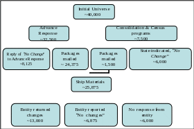
The estimated hours of burden were established using the following criteria (see figure 1). There are approximately 40,000 governmental units included in the initial BAS universe (please see figure 1). Of those 40,000 potential respondents, there are 32,500 that are included in advance response. The 7,500 remaining respondents are covered by consolidations and Census programs such as Special Census and Geographically Updated Population Certification Program (GUPCP). Of these 7,500 respondents, the Census Bureau mails packages to approximately 20% which is 1,500 respondents. Of the 32,500 advance responses, the Census Bureau mails packages to approximately 75% or 24,375 respondents. Between Advance Response and consolidations, the Census Bureau mails packages to roughly 25,875 respondents.
The number of respondents will be 34,000 since we estimate that 6,000 entities are part of a consolidated agreement with participating states. We work with the single contact within a state to determine where to mail the BAS packages. If the state contact has no record of an annexation for this BAS cycle for any of its governments, we report the respective government has no changes.
Please see the following figure on the derivation of the estimated number of BAS respondents:
Question 13. Estimate of Cost Burden
We do not expect respondents to incur any cost other than that of their time to respond. The information requested is of the type and scope normally contained in government records and no special hardware or accounting software or system is necessary to provide answers to this information collection. Therefore, respondents are not expected to incur any capital, start-up costs or system maintenance costs in responding. Further, purchasing of outside accounting or information collection services, if performed by the respondent, is part of usual and customary business practices and not specifically required for this information collection.
Question 14. Cost to Federal Government
We estimate the BAS will cost approximately $17,000,000 in 2008. We believe the cost will increase each year by approximately 3%. The amounts indicated above include costs for the Census Bureau’s National Processing Center (NPC), Regional Offices, and Headquarters. The Geographic Entities Program Branch and the Geographic Programs Budget Branch within the Geography Division, Census Bureau, have reviewed all requirements for conducting the BAS, including material and person-hour costs to arrive at this estimate and have determined that the resources are available for efficient administration of the BAS.
Question 15. Reason for Change in Burden
There is a change in burden for two reasons. First, the number of respondents has increased from 12,000 to 34,000 due to the change in the BAS mailing universe discussed earlier. Secondly, we introduced new methods of participation which changed the response time. We mail an Advance Response notice to the initial BAS universe of 40,000 in September. The governments notify us through Advance Response if they have changes. Based on this, we only mail BAS materials to those entities.
Question 16. Project Schedule
The following is the general schedule to the BAS:
Month Activity
August Prepare for advance response
September Advance Response mail-out, e-mail, and FAX, or States with specified agreements notify us of participants
October Start staging or preparing the mail-out of materials
December Complete staging or preparing the mail-out of materials
January Mail-out of packages
Start receiving and processing returns
February 15th Last day to request change in material submission method
February (late) Follow-up post card mailed
March Start telephone follow-up by the State Data Centers and the NPC
April 1st Deadline for package return to make the Population Estimated and ACS data delivery
May Complete telephone follow-up by the State Data Centers and the NPC
May 31st Deadline for package return to make the BAS materials creation
July Complete processing/updating of packages and complete contact and change action keying
All year Researching and resolution of issues
Writing requirements and procedures
Processing of data
Responding to participants
Providing training of staff and participants
Attending conferences
Establishing state and county agreements
Developing tracking control systems
Identifying more efficient methods to implement and process the BAS
Question 17. Request to Not Display Expiration Date
We will display the assigned expiration date of this information collection on the BAS forms.
Question 18. Exceptions to the Certification
There are no exceptions.
Part B – Collection of Information Employing Statistical Methods
The collection of boundary information and changes in legal status does not lend itself to statistical methods, such as sampling or estimation procedures, because of the legal implications inherent in the correct location of every municipal, county, MCD, AIA, and ANRC boundary and the need to provide a complete inventory of governments for use in Census Bureau and other programs.
Attachments
A Comments on Federal Register Notice, Vol. 71, No. 241, December 15, 2006
B BAS Letters
C BAS Forms
BAS01 Incorporated Place
BAS02 Counties and Equivalent Areas
BAS03 Minor Civil Divisions (MCDs)
BAS04 Newly Incorporated Places and Newly Activated Governments
BAS05 American Indian Reservations and Off-Reservation Trust Lands
BAS06 Consolidated BAS
BASARF1
BASARF2
D BAS Respondent Guides
Paper Respondent Guide
Tribal Paper Respondent Guide
MTPS Respondent Guide
Digital Respondent Guide
Tribal Digital Respondent Guide
1 AIAs American Indian Areas include reservations and/or off-reservation trust lands and tribal subdivisions
2 AIANNHAs American Indian, Alaska Native, Native Hawaiian Areas include reservations and/or off-reservation trust lands and tribal subdivisions, Alaska Native Regional Corporations (ANRCs) and Hawaiian home lands.
| File Type | application/msword |
| File Title | Preparing the Supporting Statement – Prepare the Supporting Statement in accordance with the following OMB instructions and su |
| Author | Bureau Of The Census |
| Last Modified By | Bureau Of The Census |
| File Modified | 2007-05-16 |
| File Created | 2007-05-14 |
© 2026 OMB.report | Privacy Policy